Tag Archives: fire danger

Dry, hot and windy conditions prompt Red Flag Warning

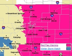
With plenty of heat and a lack of moisture the fire danger is high along the Front Range on Sunday. (National Weather Service)

September is starting off as a hot one along the Front Range and indeed across the state of Colorado.  With temperatures set to approach record highs, low humidity and windy conditions the fire danger has prompted a Red Flag Warning for Sunday.

The record high temperature for September 5th is 97 degrees and that is what Denver’s thermometer is expected to rise to today.  Humidity during the heat of the day is forecast to drop below 15% and the afternoon will bring breezy conditions with winds gusting over 30 mph. 

All of those factors will serve to dry out the Colorado Front Range and bring what the National Weather Service calls “extreme fire danger” to the area. 

The service has issued a Red Flag Warning that will be in effect from 10:00am to 9:00pm today covering the Front Range foothills and adjacent areas including Denver and Thornton.  Conditions are expected to be at their peak from 11:00am to 6:00pm.

Similarly, the Western Slope from the Continental Divide west to the Utah border is under a Red Flag warning from noon until 9:00pm. 

Colorado has made it through what has been a relatively hot summer without any major wildfires.  However conditions today are ripe and should a fire get started, it could spread rapidly and with devastating effects.  With the Labor Day holiday weekend many people will be spending time outdoors and extreme caution should be exercised. 

Stay up to date with Denver’s changing weather: Follow us on Twitter and ‘like’ us on Facebook!

Related:

For more information:

Dry and windy conditions prompt Red Flag Warning for the Front Range

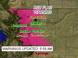
Weather warnings for April 3, 2010.
Thornton and the Front Range are under a Red Flag Warning until 8:00pm Saturday.

Thornton, the Front Range and most of southeastern Colorado are under a Red Flag Warning through 8:00pm tonight. The snow last week is a distant memory and winds and warm temperatures have created very dry conditions.

Winds have been increasing throughout the day and will continue to do so for the next few hours before they gradually ease. Humidities are exceptionally low, below 20% in many areas, and temperatures remain mild. These conditions have dried ground fuels and create a potentially hazardous situation.

Remember, a Red Flag Warning means that critical fire weather conditions are occurring or imminent. The National Weather Service said the warning will remain in place until 8:00pm this evening.

Grassfires are not uncommon this time of year and if they get started they can quickly spread thanks to the gusty winds. It was 47 years ago yesterday that winds helped to quickly burn 25,000 of land in southern Weld County near Roggen.

Red Flag Warning for most of Colorado highlights extreme fire danger

The entire eastern half of Colorado is under a Red Flag Warning through Friday evening.

The National Weather Service has updated the Red Flag Warning and it will now go into effect at 9:00am today and run through 9:00pm.  Further, the warning now covers the entire eastern half of the state of Colorado and in fact extends to the south and east into parts of Nebraska, Kansas, Oklahoma, Texas and New Mexico.  This of course covers the entire Denver metro area and the Front Range. 

The extension and widening of the warning should serve to really drive home how dry things are and how serious the fire conditions are.  Please be sure to take appropriate precautions as we certainly would like to avoid any wildfires.

RED FLAG WARNING
NATIONAL WEATHER SERVICE DENVER CO
456 AM MST FRI FEB 6 2009

…Dry and windy conditions across the plains and lower foothills today…

Very dry air will combine with strong winds to produce increased fire danger over the foothills and plains of northeast Colorado today. Winds will gust as high as 40 mph on the plains this afternoon with gusts to 50 mph in the foothills. Minimum humidities will range from 10 to 15 percent. Conditions will improve on the plains around sunset…with warm and breezy conditions lingering in and near the foothills through the early evening hours.

…Red Flag Warning now in effect from 9 am this morning to 9 pm mst this evening for gusty winds and low humidities…

The Red Flag Warning is now in effect from 9 am this morning to 9 pm mst this evening. A Red Flag Warning is now in effect for all of the plains and foothills areas of eastern Colorado… Including fire weather zones 235…236…and 238 through 251.

West winds of 20 to 35 mph will become widespread in and near the southern Front Range foothills this morning…and spread across the plains by afternoon. Gusts as high as 50 mph are possible in the foothills. Relative humidities will drop into the 8 to 15 percent range. The combination of the gusty winds…low humidities and dry fuels will create very high fire danger. The gusty winds will decrease and the relative humidities will increase this evening.

A Red Flag Warning means that critical fire weather conditions are either occurring or imminent. Please advise the appropriate officials and fire crews in the field of this Red Flag Warning.

Red Flag Warning in effect for Denver and the Front Range

A Red Flag Warning is in effect for Denver and the Front Range Thursday from 11:00am to 6:00pm.

While we have all enjoyed the record January warmth of recent days but that does come at a price.  The warm temperatures, dry wind and very low humidity have dried much of the area out to a dangerous state. 

Today we have one more warm day before we return to more seasonable weather.  With temperatures climbing into the 60’s, humidity as low as 5 percent and a west wind that will pick up later today, the fire danger is very real.  As we saw a couple weeks ago with the Olde Stage Road Fire, it doesn’t take much beyond a spark to set off a fire that can spread very quickly with as dry as it is.
 
The potentially dangerous conditions have caused the National Weather Service to issue a Red Flag Warning that will be in effect from 11:00am today through 6:00pm this evening. 

Red Flag Warning
National Weather Service, Denver
544 am MST THU JAN 22 2009

……Red Flag Warning today from 1100 to 1800 MST…for Front Range foothill zones 215 and 216 below 8000 feet…and for the I-25 urban corridor zones 238..239..240 and 241 in northeast Colorado…

One more day of unseasonably warm and very dry conditions will be accompanied by periods of gusty Chinook winds resulting in critical wildland fire conditions in and near the front range foothills in northern Colorado. Minimum relative humidities will range from 5 to 15 percent with maximum temperatures in the 60 to 70 degree range. This is as much as 25 degrees above average for the date. Furthermore west winds in and near the foothills are expected to increase later the morning…with gusts this afternoon to 40 mph in the foothills and to 30 mph on the nearby plains.

Fuels are also quite dry in the area with no precipitation in the area for some time. These critical wildland fire conditions are expected to improve this evening with dry downslope winds subsiding…and a shift to a more humid east wind overnight with a weak cold front backing into northeast Colorado.

…Red Flag Warning in effect from 11 am this morning to 6 pm MST this afternoon…

The National Weather Service in Denver has issued a Red Flag Warning…which is in effect from 11 am this morning to 6 pm MST this afternoon.

Unseasonably warm temperatures…gusty west winds and very low relative humidities will combine with very dry fuels to produce critical wildland fire conditions in and near the Front Range foothills late this morning through this afternoon. Foothill areas below 8000 feet and lower elevations west of I-25 are more likely to see these conditions develop.

Get more local news and weather information on Examiner.com.

This article and many more are posted to the Denver Weather Examiner site.

Visit Examiner.com for more local Denver news and weather.

A Red Flag Warning means that critical fire weather conditions are either occurring or imminent. Please advise the appropriate officials and fire crews in the field of this Red Flag Warning.

The heat is on, the fire danger is high!

As we head into the hot days of summer, the lack of moisture begins to drive the fire danger up. Tuesday we are expecting highs temperatures to reach 93 in the Denver metro area before a brief cool down begins but by Saturday those temps will be back up to the mid-90’s.

Much of the western slope once again finds itself under Red Flag Warnings. Frisco in Summit County and Guffey in Park County have recently battled small blazes. With the long holiday weekend approaching, lots of folks will be heading to the high country. More people means there is a greater chance for fire so everyone should be careful.

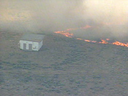
A grass fire burns near Wiggins, CO.Closer to the Front Range, while we are not currently under any fire related advisories, we are still very dry and the danger exists. Just yesterday a grass fire near Wiggins quickly blew up and consumed 2,500 acres and took six hours to contain.

Please be aware of the danger and leave the fireworks to the pros! Remember that fireworks are illegal in Thornton and can get you a $1,000 fine if you are caught using them.