Wind and big time snowstorms can visit the Mile High City this time of year and we see many such events in our look back at this week in Denver weather history. Probably most notable, the Blizzard of 1913, the Mile High City’s biggest snowstorm in history.
Stay up to date with Thornton’s weather: ‘Like’ us on Facebook and follow us on Twitter
From the National Weather Service:
1-5
In 1913…the 1st marked the start of the heaviest 5-day total snowfall in the city’s history. During this period snowfall totaled 45.7 inches. Starting on the 1st…snow fell intermittently for 3 days and accumulated a little over 8 inches. On the 4th and 5th…an additional 37.4 inches of snow fell. At Georgetown in the foothills west of Denver even more snow fell…86 inches over the 5 days with the most…63 inches…on the 4th. In Colorado…snowfall was heavy along the eastern slopes of the mountains from the Palmer Divide north. High winds during the storm caused heavy drifting…which blocked all transportation. Snow cover of an inch or more from the storm persisted for 60 consecutive days from the 1st through January 29…1914. Additional snowfall in December and January prolonged the number of days. This is the third longest period of snow cover on record in the city.
2-3
In 1955…snowfall totaled only 2.9 inches at Stapleton Airport. This was the only measurable snowfall of the month.
In 1973…post-frontal heavy snowfall totaled 7.6 inches at Stapleton International Airport where northeast winds gusting to 37 mph caused some blowing snow.
In 1990…strong downslope winds raked the eastern foothills and most of metro Denver. A wind gust to 87 mph was recorded at Rollinsville with wind gusts to 58 mph in Arvada and 55 mph in Lakewood. West winds gusted to 48 mph at Stapleton International Airport on the 2nd.
In 1997…heavy snow fell in the foothills. Conifer received 10 inches of new snow. Snowfall totaled only 2.4 inches at the site of the former Stapleton International Airport on the 1st…2nd…and 3rd. North winds gusted to 24 mph at Denver International Airport on the 2nd.
2-4
In 1909…post-frontal snowfall totaled 6.1 inches in downtown Denver. Most of the snow…5.9 inches…fell between 6:00 pm on the 2nd and 6:00 pm on the 3rd. North winds were sustained to 18 mph on both the 2nd and 3rd.
2-17
In 1939…more than 2 weeks of unseasonably warm weather made the month the 3rd warmest on record. Seven daily temperature records were set…including the all time record high temperature for the month of 79 degrees on the 5th. Daytime highs were balmy with 14 days in the 60’s and 70’s. Low temperatures dipped to freezing or below on only 5 days. The period was dry with only a trace of snow on the 12th.
3
In 1977…high winds continued in Boulder and were clocked from 74 to 90 mph…causing only minor damage. Northwest winds gusted to 33 mph at Stapleton International Airport where the strong Chinook winds warmed the temperature to a high of 63 degrees.
In 1985…wind gusts to 78 mph were clocked at Table Mesa in Boulder. Winds gusted to 70 mph at Echo Lake west of Denver.
In 2011…Another round of snow developed in and near the Front Range Foothills. The heaviest snowfall occurred in the foothills of Boulder and northern Jefferson Counties. Storm totals included: 13 inches…7 miles southwest of Boulder; 10.5 inches…4 miles east-northeast of Nederland; 10 inches at Genesee; 9.5 inches…4 miles west-northwest of Boulder; 9 inches at Gross Reservoir and 4 miles east of Pinecliffe. Around the Urban Corridor…storm totals ranged from 3 to 8 inches…heaviest in and around Boulder.
3-4
In 1968…strong Chinook winds in Boulder gusting to 52 mph downtown caused 7 thousand dollars in damage. Flying debris damaged cars…houses…and other property in Boulder. West winds gusted to 49 mph late on the 3rd and to 45 mph on the 4th at Stapleton International Airport where the temperature climbed to a high of 60 degrees on the 4th.
In 1970…strong winds whistled through Boulder. Sustained winds of 40 mph with gusts to 70 mph were recorded at the National Bureau of Standards in Boulder. Wind gusts to 50 mph occurred in downtown Denver. No damage was reported. On the 3rd…northwest winds gusted to 40 mph at Stapleton International Airport where the Chinook winds warmed the temperature to a high of 66 degrees on the 4th.
In 1999…heavy snow fell over the foothills and metro Denver. The heaviest snowfall occurred in the foothills south of I-70 and near the Palmer Divide. Snowfall totals included: 25 inches near Tiny Town; 18 inches at Conifer; 15 inches near Evergreen; 14 inches at Chief Hosa…8 miles west of Castle Rock…and near Blackhawk; 12 inches at Pine Junction and 8 miles south of Sedalia; 11 inches atop Floyd Hill and in Roxborough; and 10 inches at Castle Rock. Around metro Denver…snowfall totals included: 10 inches at Highlands Ranch…9 inches at Parker…and 8 inches in Aurora and Wheat Ridge. Elsewhere around the metro area…snowfall generally ranged from 3 to 5 inches. Only 3.2 inches of snow fell at the site of the former Stapleton International Airport. North winds gusted to 32 mph at Denver International Airport on the 3rd.
In 2007…high winds developed in and near the Front Range foothills. Peak wind reports included: 88 mph atop Niwot Ridge; 87 mph atop mines peak; 80 mph…3 miles southeast of Jamestown; 78 mph at Longmont; 74 mph at Table Mesa. A few power outages occurred in Longmont as broken branches downed power lines. Northwest winds gusted to 38 mph at Denver International Airport on the 4th.
In 2013…a storm system brought heavy snow to parts of the Front Range Foothills. Storm totals included: 12 inches…7 miles west-southwest of Evergreen; 10.5 inches…3 miles north of Bailey; 9.5 inches…3 miles west of Jamestown and 5 miles northeast of Ward; 9 inches in Bailey…8.5 inches… 3 miles north of Conifer. Continue reading December 3 to December 9: This week in Denver weather history→
Cold, snow and wind are the dominant conditions we see in our look back at this week in Denver weather history. All three are common this time of year and extremes with those conditions seem to be unusually common as well.
Among the highlights are numerous high wind events that not only caused damage but also injury to unprepared residents. Significant snowfall also appears many times including a storm in 1983 that shut down the city for the Thanksgiving weekend and left snow on the ground for 63 days.
Stay up to date with Thornton’s weather: ‘Like’ us on Facebook and follow us on Twitter
From the National Weather Service:
25-26
In 1887…snowfall totaled 2.9 inches in the city. This was the only measurable snow of the month. Northeast winds were sustained to 18 mph on the 26th when the temperature dipped to 12 degrees below zero.
In 1959…a sharp cold front produced a northwest wind gust to 51 mph…followed by snow and falling temperatures from a high of 60 degrees to a low of 23 degrees at midnight on the 25th. Snowfall totaled 4.4 inches at Stapleton Airport before ending early on the 26th.
In 1972…winds gusted to 104 mph at the Rocky Flats plant south of Boulder. Gusts to 70 mph were recorded at the National Bureau of Standards in Boulder…while in downtown Boulder winds peaked to 68 mph. Some damage was reported. Northwest winds gusted to 47 mph at Stapleton International Airport on the 26th.
In 1984…blowing snow closed I-70 east of Denver…stranding over a thousand travelers in Limon. Denver received only 2.3 inches of snowfall. North winds gusted to 31 mph at Stapleton International Airport.
In 1999…strong Chinook winds redeveloped overnight in and near the foothills. Peak wind gusts included 72 mph atop Blue Mountain near Wondervu and at the National Center for Atmospheric Research mesa lab above Boulder.
25-27
In 1978…heavy snowfall of 6.0 inches was measured at Stapleton International Airport where north winds gusted to 20 mph. Most of the snow…4.8 inches…fell on the 25th. The greatest amount of snow measured on the ground was 5 inches due to settling and melting.
25-28
In 1952…the average coldest 4-day period in November in the previous 81 years of record occurred. Maximum temperatures of 19…15…21…and 25 degrees were recorded. Minimum temperatures were below zero each day with readings of 7 below…6 below…5 below…and 6 below.
25-29
In 1985…dense fog with visibilities as low as 1/8 mile occurred on five consecutive days at Stapleton International Airport. The fog was at times accompanied by light snow… Light freezing drizzle…or ice crystals. Fog occurred all day on both the 26th and 29th.
26
In 1873…west winds increased to a violent gale at 3:00 am and reached a maximum sustained velocity of 56 mph at 3:15 am. The winds continued with a velocity of not less than 40 mph until 6:00 am. Winds continued brisk for the remainder of the day. The strong winds caused damage to houses and buildings in the city. Temperatures were in the 50’s through early afternoon with a recorded high of 59 degrees. Winds also blew strongly in Boulder and caused 300 dollars in damage.
In 1911…post-frontal northeast winds were sustained to 43 mph with gusts as high as 52 mph. Snowfall was only 0.5 inch.
In 1965…post-frontal snowfall totaled 5.5 inches at Stapleton International Airport where strong west winds gusted to 39 mph during the afternoon.
In 1976…2 to 4 inches of snow with an arctic cold front produced near zero visibility at times in blowing snow… Causing multiple automobile accidents in metro Denver. Snowfall totaled 3.5 inches at Stapleton International Airport where north winds gusted to 39 mph. Temperatures hovered in the teens and lower 20’s most of the day dipping to 7 degrees by midnight.
In 1977 a strong wind storm raked metro Denver. High winds blew windows from office towers in Denver and Boulder. Thirteen people were injured in Boulder due to flying debris. Wind gusts to 119 mph were clocked on Davidson Mesa southeast of Boulder…with 109 mph in downtown Boulder. Six airplanes were damaged at Jefferson County Airport near Broomfield. Winds to 90 mph were reported in Lakewood. Glass was blown out of several vehicles in Wheat Ridge…and roofs were blown off 4 houses in Arvada. Several houses under construction collapsed across metro Denver. Winds to 75 mph were reported at the Denver Federal Center with 90 mph at Rocky Flats. West winds gusted to 51 mph at Stapleton International Airport. Total insured damage from the wind storm was 2.2 million dollars.
In 1987…a thanksgiving snowstorm brought 5 inches of snow to metro Denver and 6 inches to the foothills. At Stapleton International Airport…snowfall totaled 5.0 inches…north winds gusted to 22 mph…and temperatures hovered in the upper 20’s most of the day.
In 1991…strong winds were recorded in and near the eastern foothills. Winds at Rollinsville were clocked to 70 mph with 45 mph recorded in Boulder and 51 mph at the U.S. Atomic Energy Commission Rocky Flats plant. West winds gusted to only 28 mph at Stapleton International Airport.
26-27
In 1876…heavy snowfall totaled 9.0 inches over the city from 5:00 pm on the 26th through 5:00 p.m. on the 27th. Precipitation was 0.30 inch on the 25th and 0.60 inch on the 27th.
In 1919…an incursion of cold arctic air produced snowfall of 4.6 inches over downtown Denver. Temperatures dipped to 5 degrees below zero on the evening of the 26th and recovered to a high of only 1 degree below zero on the 27th…the all-time record low maximum for the month of November and the record for the date. Northwest winds were sustained to 25 mph with gusts to 26 mph on the 26th.
In 1923…snowfall of 2.0 inches was the only snow of the month. North winds were sustained to 22 mph on the 26th.
In 1972…heavy snowfall totaled 7.5 inches at Stapleton International Airport where north winds gusted to only 18 mph on the 27th.
In 1983…a Thanksgiving blizzard dumped 21.5 inches of snowfall in 37 hours with a maximum of 18 inches on the ground at Stapleton International Airport. The storm produced howling winds…which paralyzed Thanksgiving weekend transportation across all of eastern Colorado. On the 27th…Stapleton International Airport closed… Opening 24 hours later. Interstate highways were closed in all directions…but west…from Denver. At Stapleton International Airport…north winds gusted to 36 mph on the 26th and to 29 mph on the 27th. However…most wind speeds across metro Denver were 15 to 30 mph. Temperatures hovered in the teens and lower 20’s. Many stores and businesses closed. Several high school football games were postponed. Across metro Denver…snow depth varied from 15 inches in Commerce City to 28 inches near Chatfield Reservoir. Snow removal in Denver was estimated at 1.5 million dollars. Following the storm… An inch or more of snow remained on the ground for 63 consecutive days through January 27…1984. This is the longest period of continuous snow cover ever recorded in Denver.
In 1990…an early winter storm deposited 2 to 8 inches of wet snow across metro Denver. Snowfall totaled 3.4 inches at Stapleton International Airport where northeast winds gusted to 30 mph on the 26th.
In 1993…strong winds swept off the foothills across metro Denver. Sustained winds of 30 to 50 mph were common across the area. Wind gusts to 67 mph were recorded atop Squaw Mountain near Idaho Springs. West winds gusted to 36 mph at Stapleton International Airport on the 26th. The strong winds produced some blowing snow…reducing the visibility to less than one mile at times.
In 1995…snowfall totaled 3.7 inches at the former Stapleton International Airport site. The foothills west of Denver received 4 to 7 inches of snow. North-northeast winds gusted to 34 mph at Denver International Airport on the 26th.
27
In 1965…strong winds buffeted Boulder…causing 11 thousand dollars in damage. Wind gusts to 75 mph were recorded downtown. West winds gusted to 38 mph at Stapleton International Airport.
In 1994…winds gusted to 87 mph atop Squaw Mountain…5 miles south of Idaho Springs…and to 84 mph on Fritz Peak near Rollinsville in the foothills southwest of Boulder. Northwest winds gusted to 40 mph at Stapleton International Airport.
In 2017…The maximum temperature for Denver reached 81 degrees which was 34 degrees above the normal high of 47 degrees. This difference between the actual high and the normal high was the second largest ever recorded for Denver. The only larger difference occurred on Dec 5…1939 when Denver was 35 degrees above normal. It also established a new record for the latest 80 degree day for the calendar year in Denver… breaking the previous date by 11 days.
28
In 1884…a windstorm during the afternoon produced northwest sustained winds to 46 mph. Two wooden slats were blown out of the weather instrument shelter…and nearly all of the slats on the north and west sides were loosened.
In 1898…northwest winds were sustained to 50 mph with gusts as high as 80 mph.
In 1902…northwest winds were sustained to 40 mph with gusts to 48 mph. The strong apparent Bora winds warmed the temperature to a high of only 40 degrees.
In 1904…northwest winds sustained to 44 mph with gusts to 58 mph warmed the temperature to a high of 58 degrees.
In 1927…strong west winds occurred in Boulder…causing widespread minor damage. A wind gust to 65 mph was recorded at Valmont east of Boulder. The west winds possibly produced a cyclonic twist.
In 1928…heavy snowfall totaled 7.0 inches over downtown Denver.
In 1957…a vigorous cold front produced north-northeast wind gusts to 54 mph at Stapleton Airport. Light snow following the front totaled only 0.2 inch.
In 1970…strong Chinook winds reached 77 mph in downtown Boulder.
In 1978…wind gusts 60 to 90 mph were reported in and near the foothills.
In 1984…high winds of 60 to 80 mph occurred along the Front Range eastern foothills.
In Boulder…the high winds blew the roof off a service station. Several trees were felled… Damaging some cars. An elderly woman was injured when she was knocked down by a wind gust and blown 20 feet into some bushes. Northwest winds gusted to 36 mph at Stapleton International Airport.
In 1994…winds gusted to 72 mph in Boulder. No damage was reported. Northwest winds gusted to 35 mph at Stapleton International Airport.
28-29
In 1908…heavy snowfall overnight and for most of the day on the 29th totaled 12.5 inches. Precipitation was 1.09 inches. Northwest winds were sustained to 26 mph on the 29th.
In 1928…a major storm dumped 15.5 inches of snowfall on downtown Denver. North winds were sustained to 18 mph with gusts to 19 mph on the 28th.
In 1992…an upper level storm system moved across metro Denver…but left only a dusting of snow. Snowfall totaled only 1.6 inches at Stapleton International Airport where north winds gusted to 25 mph. Other snow amounts included: 8 inches at Conifer…6 inches at Lake Eldora…3 inches at Rollinsville and in southeast Denver.
In 1997…a storm system tracking across northern New Mexico produced strong north to northeast upslope flow against the eastern slopes of the Front Range and Palmer Ridge. Snowfall totals in Jefferson County included: 14 inches near Deckers; 12 inches at Castle Rock and Sedalia; 10 inches near Conifer…11 miles southwest of Morrison…and at Buffalo Creek. Elsewhere…snow accumulations were less. Snowfall totaled only 0.7 inch at the site of the former Stapleton International Airport on the 27th and 28th.
In 2004…heavy snow fell in the foothills and across metro Denver. In the foothills…snowfall totals included: 13 inches at Roxborough State Park and Eldorado Springs… 11.5 inches near Conifer…11.0 inches near Nederland…and 10 inches near Indian Hills. Across metro Denver snowfall totaled 14 inches near Sedalia…9 inches near Louisville… 8 inches at Ralston Reservoir…and 5.1 inches in the Stapleton area of Denver. Northeast winds gusted to 28 mph at Denver International Airport on the 28th.
In 2006…a slow moving storm system brought heavy snow to the mountains and to the eastern foothills where snowfall ranged from 8 to 18 inches. Some of the more impressive snow totals included: 18 inches at Genesee…17.5 inches near Boulder…17 inches at Aspen Springs…16.5 inches 10 miles northwest of Golden…15 inches at Eldorado Springs… 14.5 inches in Idaho Springs and near Jamestown…12 inches in grant and near Indian Hills…11.5 inches near Blackhawk… 11 inches at Gross Reservoir and Eldora…and 10.5 inches in Conifer. Across metro Denver…storm total snowfall generally ranged from 5 to 9 inches with the heaviest amounts near the foothills in Boulder and Jefferson counties. The most impressive totals included: 15.5 inches at Ken Caryl…12 inches in Boulder…7.5 inches near Morrison…and 7 inches near both Chatfield and Ralston reservoirs. Snowfall totaled only 4.2 inches in the Denver Stapleton area. Northeast winds gusted to 31 mph at Denver International Airport on the 28th.
28-30
In 1991…a winter storm dumped heavy snow in the foothills and near the palmer divide with 10 inches recorded at Conifer and Golden Gate Canyon…12 inches in Morrison… 6 inches at Castle Rock and Parker. Only 3.4 inches of snow fell at Stapleton International Airport where north winds gusting to 35 mph on the 29th…produced some blowing snow. Some light freezing drizzle also fell on the 28th and 29th.
29
In 1877…the all-time lowest recorded minimum temperature in the month of November…18 degrees below zero…occurred. The high temperature for the day was 16 degrees.
In 1899…northwest winds were sustained to 51 mph with gusts as high as 60 mph. The Chinook winds warmed the temperature to a maximum of 74 degrees…a record high for the date and the warmest of the month that year. The minimum temperature was only 39 degrees.
In 1927…post-frontal rain changed to snow and totaled 5.8 inches over downtown Denver. Northeast winds were sustained to 22 mph.
In 1977…85 mph winds were reported at Wondervu in the foothills southwest of Boulder. Northwest winds gusted to 39 mph at Stapleton International Airport.
In 1980 strong Chinook winds reached 85 mph in Boulder… Blowing traffic signals and street lights down. Some windows were shattered by the wind. West winds gusted to 37 mph at Stapleton International Airport.
In 1994…high winds blew across the Front Range eastern foothills. Wind gusts to 92 mph occurred atop Squaw Mountain…5 miles south of Idaho Springs…and to 82 mph on Fritz Peak near Rollinsville in the foothills southwest of Boulder. A wind gust to 75 mph was recorded at Jefferson County Airport near Broomfield. Northwest winds gusted to only 35 mph at Stapleton International Airport. No damage was reported. 29-30 in 2008…a storm system produced locally heavy bands of snow across Douglas…Elbert and eastern Jefferson counties. Northerly winds gusting to 50 mph caused snow drifts to pile up to 2 feet in depth. Storm totals included: 12 inches just southwest of Kassler…11.5 inches…6.5 miles southwest of Castle Rock; 11 inches…8.4 miles southeast of Aurora and 9 miles west of Littleton; 10 inches at Louviers… 8 inches…2 miles west-southwest of Highlands Ranch and 5 miles south-southeast of Sedalia…and 7.5 inches…14 miles west-southwest of Agate and at Castle Pines. At Denver International Airport…2 inches of snow was observed. North winds gusted to 46 mph on the 30th.
30
In 1899…west winds were sustained to 45 mph with gusts as high as 48 mph.
In 1903…west winds sustained to 44 mph with gusts to 54 mph warmed the temperature to a high of 57 degrees.
In 1981…strong winds blasted the foothills. In Wondervu… Winds were clocked to 81 mph with many other locations in the foothills reporting over 60 mph. Northwest winds gusted to 28 mph at Stapleton International Airport.
In 1986…the worst snow storm of the season dumped from 5.0 inches of snow at Stapleton International Airport to 14 inches over the higher southwestern suburbs. On the Sunday after Thanksgiving…one of the busiest travel days of the year at Stapleton International Airport…two of the four runways were closed and flights were delayed up to four hours. Near-blizzard conditions prevailed on the plains east of Denver…closing both I-70 and I-76 for a time. North wind gusts to 36 mph were recorded at Stapleton International Airport.
In 2000…strong winds raked metro Denver. In Thornton…a construction worker was critically injured when the scaffolding on which he was standing collapsed…throwing him 25 feet to the ground. West winds gusted to 54 mph at Denver International Airport.
30-1
In 1929…heavy snow blanketed the city. Snowfall totaled 9.8 inches downtown. North winds were sustained to 32 mph with gusts to 37 mph on the 30th.
In 1970…high winds blasted Boulder and the eastern plains. In Boulder…a wind gust to 112 mph was recorded at the National Center for Atmospheric Research with a gust to 96 mph at the National Bureau of Standards. In downtown Boulder…wind gusts reached 76 mph. At Stapleton International Airport…winds gusted to 47 mph. The high winds caused widespread light to moderate property damage across most of metro Denver. Roofs…signs…trees…power lines…and other property were damaged. Blowing dust reduced visibility to near zero over most of eastern Colorado. Several mobile homes…campers…and semi-trailers were blown off the highways north of Denver.
In 1985…an intrusion of cold arctic air into metro Denver resulted in setting 3 temperature records. The temperature climbed to only 17 degrees on the 30th…setting a record low maximum for the date. On the 1st…the temperature plunged to 6 degrees below zero…setting a record low for the date… And warmed to only 7 degrees…setting a record low maximum for the date.
30-2
In 1975…very strong Chinook winds up to 100 mph caused damage to homes…aircraft…aircraft hangars…mobile homes… Cars…and power lines along the eastern foothills. Strong northwest winds gusted to 39 mph at Stapleton International Airport on both the 30th and the 1st.
1
In 1899…northwest Chinook winds were sustained to 47 mph with gusts to 60 mph. The strong Chinook winds warmed the temperature to a high of 61 degrees…the warmest of the month. The low temperature dipped to only 39 degrees.
In 1972…strong Chinook winds gusted in excess of 65 mph in Boulder. There were no reports of damage. Northwest winds gusted to 38 mph at Stapleton International Airport.
In 1992…strong winds continued through the early morning hours. Wind gusts to over 70 mph were measured at reporting sites in the foothills west of Denver. In west Boulder…wind gusts reached 71 mph with 77 mph measured at Rollinsville. At Stapleton International Airport northwest winds gusted to 39 mph. The walker ranch…an historic site west of Boulder…burned down overnight during the high wind event. Although the winds did not cause the fire…they did hamper efforts to extinguish the blaze.
In 1996…high winds howled in and near the Front Range foothills. Winds gusted to 105 mph at Wondervu southwest of Boulder and to 70 mph at Jefferson County Airport near Broomfield. West winds gusted to only 24 mph at Denver International Airport.
1-2
In 1933…apparent post-frontal heavy snowfall totaled 8.0 inches across downtown Denver. North winds were sustained to 17 mph with an extreme velocity to 18 mph on the 1st.
In 1981 strong winds gusted to over 70 mph along the foothills. A peak gust to 100 mph was recorded at Wondervu. A gust to 94 mph was recorded just west of Boulder. Roofs on houses were damaged in the Evergreen area…and some mobile homes also were damaged. At Stapleton International Airport…northwest winds gusted 44 mph on the 1st and 37 mph on the 2nd.
1-5
In 1913…the 1st marked the start of the heaviest 5-day total snowfall in the city’s history. During this period snowfall totaled 45.7 inches. Starting on the 1st…snow fell intermittently for 3 days and accumulated a little over 8 inches. On the 4th and 5th…an additional 37.4 inches of snow fell. At Georgetown in the foothills west of Denver even more snow fell…86 inches over the 5 days with the most…63 inches…on the 4th. In Colorado…snowfall was heavy along the eastern slopes of the mountains from the Palmer Divide north. High winds during the storm caused heavy drifting…which blocked all transportation. Snow cover of an inch or more from the storm persisted for 60 consecutive days from the 1st through January 29…1914. Additional snowfall in December and January prolonged the number of days. This is the third longest period of snow cover on record in the city.
2
In 1893…northwest winds were sustained to 42 mph with gusts to 46 mph. Snowfall was only 1.4 inches in the city.
In 1895…0.01 inch of melted snow from 0.7 inch of snowfall was the only measurable precipitation of the month in downtown Denver…ranking the month the 3rd driest December on record.
In 1899…post-frontal northeast winds sustained to 44 mph with gusts to 59 mph caused the temperature to plunge from a high of 55 degrees to a low of 15 degrees. Snowfall was only 1.0 inch.
In 1902…apparent post-frontal northwest winds were sustained to 45 mph with gusts to 53 mph. A trace of snow fell.
In 1905…only a trace of snow fell in downtown Denver. This was the only snow and precipitation for the month… Ranking the month the second driest and the second least snowiest December on record.
In 1921…snowfall was 5.5 inches in downtown Denver. Northwest winds were sustained to 24 mph with an extreme velocity of 25 mph.
In 1951…a vigorous pacific cold front produced a northwest wind gust to 51 mph at Stapleton Airport where brief blowing dust was observed.
In 1957…a strong pacific cold front produced northwest wind gusts to 54 mph at Stapleton Airport where the surface visibility was briefly reduced to 1 1/2 miles in blowing dust.
In 1977…high winds in Boulder lifted a warehouse from its foundation and ripped it apart. Wind gusts from 60 to 103 mph toppled and injured a man while walking. Winds were clocked to 104 mph at Nederland…100 mph at Morrison…and 62 mph at Rocky Flats. Northwest winds gusted to 41 mph at Stapleton International Airport.
In 1996…for the second day in a row high winds ripped the Front Range foothills. Winds gusted to 81 mph in Golden Gate Canyon. West-northwest winds gusted to 37 mph at Denver International Airport.
In 2013…high winds developed ahead of an approaching storm system. The strong winds downed several trees around Evergreen. Peak wind gusts included: 79 mph…4 miles west-southwest of Eldorado Springs; 78 mph…3 miles south of Evergreen; 75 mph and the NCAR Mesa Lab; and 69 mph in Longmont.
2-3
In 1955…snowfall totaled only 2.9 inches at Stapleton Airport. This was the only measurable snowfall of the month.
In 1973…post-frontal heavy snowfall totaled 7.6 inches at Stapleton International Airport where northeast winds gusting to 37 mph caused some blowing snow.
In 1990…strong downslope winds raked the eastern foothills and most of metro Denver. A wind gust to 87 mph was recorded at Rollinsville with wind gusts to 58 mph in Arvada and 55 mph in Lakewood. West winds gusted to 48 mph at Stapleton International Airport on the 2nd.
In 1997…heavy snow fell in the foothills. Conifer received 10 inches of new snow. Snowfall totaled only 2.4 inches at the site of the former Stapleton International Airport on the 1st…2nd…and 3rd. North winds gusted to 24 mph at Denver International Airport on the 2nd.
2-4
In 1909…post-frontal snowfall totaled 6.1 inches in downtown Denver. Most of the snow…5.9 inches…fell between 6:00 pm on the 2nd and 6:00 pm on the 3rd. North winds were sustained to 18 mph on both the 2nd and 3rd.
2-17
In 1939…more than 2 weeks of unseasonably warm weather made the month the 3rd warmest on record. Seven daily temperature records were set…including the all time record high temperature for the month of 79 degrees on the 5th. Daytime highs were balmy with 14 days in the 60’s and 70’s. Low temperatures dipped to freezing or below on only 5 days. The period was dry with only a trace of snow on the 12th.
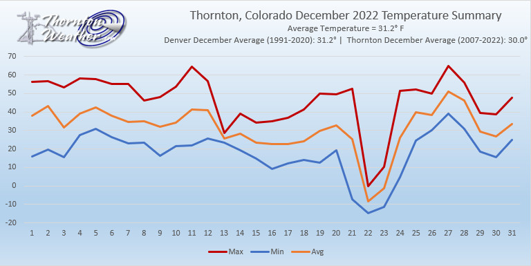
Thornton, Colorado’s December 2022 Temperature Summary. (ThorntonWeather.com)
For Thornton, December 2022’s weather was pretty much on par with what we would expect. Average mercury readings came in a bit above normal as did snowfall.
Our overall average temperature for the month came in at 31.2 degrees. This is above the 16-year running average for December of 30.0 degrees. While we did experience some extreme cold for a few days, that was balanced out by a good number of days with above normal readings.
Denver International Airport, where the Mile High City’s official measurements are taken, averaged 29.3 degrees, a rare occasion where the airport was colder than us. This was a good bit below the 30-year Denver average for December of 31.2 degrees.
In Thornton, our readings ranged from a high of 65.0 degrees on the 27th to a bone chilling low of -14.6 degrees on the 22nd. Denver saw a high of 64 degrees on the 11th and a low of -24 on the 22nd.
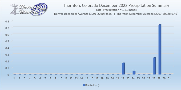
In terms of precipitation, Thornton’s reading came in far above the 16-year average with 1.21 inches of liquid precipitation. Much of that can be attributed to the storm on the 28th and 29th that saw us receive nearly one inch combined between rain and snow melt. The monthly total made December 2022 Thornton’s wettest December of the past 16 and was far above the average of 0.46 inches.
Denver nearly matched our number with 1.18 inches at the airport. This was well above the Mile High City’s December average of 0.35 inches.
For the first three weeks of the month, Thornton saw no snow at all. Then, two storms saved the month. Thornton ended up with 11.1 inches, about an inch more than the 16-year running average of 10.2 inches for December.
Denver actually bested us for the month with 13.0 inches. That is well above the average of 8.0 inches for December since 1882.
The Denver city and county building lit up for the holidays. (Bobby H)
The month of December can offer everything from bone dry conditions to bone chilling cold and monstrous snowstorms. The weather and wildlife all afford an abundance of photo opportunities as our December photo slideshow shows.
Leaves have fallen from trees now and the landscape can sometimes look quite stark. However it only takes a quick shot of snow to change that picture greatly. Throw in gorgeous sunrises and sunsets, plenty of wildlife big and small, kids playing and much more and the month can be quite colorful and eventful.
Slideshow updated December 30, 2022
To learn more about how to send your photo to us for inclusion in the slideshow, see below the slideshow.
Showcasing images captured by ThorntonWeather.com readers as well as some of our own, our monthly slideshow covers the entire gamut of weather-related imagery.
Sunsets, sunrises, wildlife and of course every type of weather condition are vividly depicted in images captured from yours and our cameras.
[flickr_set id=”72177720304403809″]
What is missing in the slideshow above? Your photo!
Our monthly photo slideshow is going to feature images that we have taken but more importantly images that you have captured. The photos can be of anything even remotely weather-related.
Landscapes, current conditions, wildlife, pets, kids. Whimsical, newsy, artsy. Taken at the zoo, some other area attraction, a local park, a national park or your backyard. You name it, we want to see and share it!
Images can be taken in Thornton, Denver or anywhere across the extraordinary Centennial State. We’ll even take some from out of state if we can tie it to Colorado somehow.
We’ll keep the criteria very open to interpretation with just about any image eligible to be shown in our slideshows.
What do you win for having your image in our slideshow? We are just a ‘mom and pop’ outfit and make no money from our site so we really don’t have the means to provide prizes. However you will have our undying gratitude and the satisfaction that your images are shared on the most popular website in Thornton.
To share you images with us and get them included in the slideshow just email them to us or share them with ThorntonWeather.com on any of the various social media outlets. Links are provided below.
Christmas Day is normally a relatively quiet day in terms of the weather as we recently discussed but the week between it and New Year’s can be quite eventful. Among the highlights are a prolonged period of sub-zero temperatures that lasted nearly five days. As you might expect, there have also been notable snowstorms that snarled holiday traffic as well.
From the National Weather Service:
20-25
In 1983…an extremely bitter cold spell occurred. The temperature remained below zero for 115 hours in Denver… The longest sub-zero period on record. The mercury dipped to 21 degrees below zero on the 21st…the coldest recorded temperature in over 20 years. The cold was accompanied by winds that plunged chill factors to 50 to 70 degrees below zero. Two people froze to death in Denver; both were found outside dead of exposure. Numerous cases of frostbite were reported. Hundreds of water pipes broke from the intense cold…water mains and natural gas lines also fractured…and electricity consumption reached record levels. Light snow totaling 5.8 inches fell at times…and holiday traffic was delayed at Stapleton International Airport for several hours. Eight daily temperature records were set at the time. The all-time record low maximum temperature for the month of 8 degrees below zero on the 21st still stands today. Other temperature records still standing include record low maximum temperatures of 5 degrees below zero on both the 22nd and 23rd and 4 degrees below zero on the 24th.
24-25
In 1891…heavy snowfall of 7.0 inches in downtown Denver provided a white Christmas. Most of the snow…6.5 inches… Fell on the 24th. Northwest winds were sustained to 30 mph with gusts to 40 mph on the 24th.
In 1894…snow began falling during the evening of the 24th… Ended during the early afternoon of the 25th…and totaled 6.4 inches in downtown Denver. Northwest winds were sustained to 26 mph with gusts to 30 mph on the 24th. The maximum snow depth on the ground was 5 inches. The high temperature was only 18 degrees on the 25th after a low of 8 degrees.
In 1980…strong Chinook winds of 50 to 60 mph occurred in the foothills with a wind gust to 90 mph recorded at Wondervu. West winds gusted to 33 mph at Stapleton International Airport on the 25th.
In 1997…a relatively rare Christmas snowstorm blanketed much of northeastern Colorado. Snowfall in and near the Front Range foothills and south of metro Denver ranged from 5 to 8 inches. Elsewhere…new snow accumulations were generally 1 to 3 inches. Snowfall totaled only 1.5 inches at the site of the former Stapleton International Airport. North winds gusted to 29 mph at Denver International Airport on the 24th.
In 2012…a winter-like weather moved into northeast Colorado on Christmas Eve as an upper level trough and a strong cold front moved through the region. At Denver International Airport…2.5 inches of snow fell from Christmas Eve through Christmas morning. The high temperatures on Christmas Day only reached 16 degrees…which was the coldest day of the month.
In 2017…deep moisture and a strong jet stream brought a wave of heavy snow and strong winds to the mountains of north central Colorado. Storm totals included: 22 inches near Loveland Pass…15.5 inches near Copper Mountain…Eldora and 5 miles west-southwest of Guanella Pass; with 13.5 inches near Brainard Lake.
25
In 1873…northwest winds were sustained to 36 mph during the morning and to 48 mph in the evening. The Chinook winds warmed the temperature to a high of 53 degrees.
In 1883…gusty very strong winds raked Boulder…causing 11 hundred dollars in damage.
In 1985…Table Mesa in Boulder was buffeted by wind gusts to 68 mph.
In 1993…occasional high winds occurred over portions of the higher foothills west of Boulder and Denver. A wind gust to 87 mph was recorded on squaw mountain…and a gust to 83 mph occurred at Rollinsville. Northwest winds gusted to 35 mph at Stapleton International Airport.
In 2007…a winter storm brought heavy snow to the Front Range of Colorado. The heaviest snow fell near the foothills of Boulder…Douglas and Jefferson counties. The snow caused accidents throughout the Denver metropolitan area. Gusty winds produced snow drifts from 2 to 3.5 feet in depth. Total snowfall for the calendar day in Denver was 7.8 inches…setting a new record for Christmas Day. The measurement was taken at the former Stapleton International Airport; the previous record was 6.2 inches… Set in 1894. Storm totals in the Front Range foothills included: 13.5 inches at Coal Creek Canyon; 12 inches…5 miles east-southeast of Aspen Park; 11 inches; 6 miles southwest of kassler; 10.5 inches at Eldorado Springs. Elsewhere…storm totals ranged from 5 to 10 inches. In the urban corridor storm totals included: 9 inches near Elizabeth; 8 inches in southwest Denver…Highlands Ranch…Marston Reservoir and Wheat Ridge; 7.5 inches in Arvada; 7 inches in Centennial and Lakewood; 6.5 inches in Aurora and 8 miles southeast of Watkins; 6 inches in Boulder…Englewood and Parker. Elsewhere…storm totals ranged from 3 to 5 inches.
25-26
In 1904…after a warm Christmas Fay with a high temperature of 50 degrees…a late day cold front plunged temperatures to a low of 7 degrees…produced northeast winds sustained to 40 mph with gusts to 54 mph…and produced 5.2 inches of snow overnight for a late white Christmas. The maximum temperature on the 26th was only 16 degrees.
In 2014…a winter storm brought a rare Christmas Day snowfall to the Front Range Foothills and Urban Corridor…from the afternoon of the 25th to the evening of the 26th. Storm totals included: 12.5 inches…4 miles west of Boulder; 12 inches…4 miles southwest of Eldorado Springs and 4 miles south of Golden; 11 inches at Genesee; 10 inches near Allenspark…5 miles west of Chatfield Reservoir… 5 miles southwest of Golden and near Tiny Town; 8 inches in Lakewood and Louisville; 7.5 inches in Niwot; 7 inches in Longmont; with 6 inches in Broomfield and Frederick. At Denver International Airport…5.1 inches of snowfall was observed.
25-31
In 1980…temperatures were unusually warm during the week between Christmas and New Year’s. High temperatures for the week ranged from the mid-50’s to the mid-70’s. Four temperature records were set. Record highs occurred on the 26th with 68 degrees…the 27th with 75 degrees…and the 30th with 71 degrees. A record high minimum temperature of 41 degrees occurred on the 27th.
26
In 1877…heavy snow fell during the early morning and totaled nearly 6 inches. Precipitation from melted snow was 0.58 inch. After the snowfall…a number of sleighs were seen on the city streets.
In 1879…after a morning low of 4 degrees below zero… The temperature climbed to a high of 57 degrees in the city.
In 1907…west winds were sustained to 40 mph. The Chinook winds warmed the temperature to a high of 62 degrees.
In 1949…west winds gusted to 50 mph at Stapleton Airport.
In 1998…intense…but localized…downslope high winds developed near Wondervu in the foothills southwest of Boulder. Winds frequently gusted to 100 mph with a highest reported wind gust to 104 mph. West winds gusted to only 43 mph at Denver International Airport.
26-27
In 1954…a major storm dumped heavy snow across metro Denver. Snowfall totaled 8.6 inches at Stapleton Airport. The storm produced the heaviest snowfall of the calendar year and was the only measurable snowfall in December.
In 1987…a snowstorm stalled in northeastern Colorado…giving metro Denver its worst winter storm in 4 years. Total snowfall from the storm ranged from 12 to 18 inches on the east side…1 to 2 feet in Boulder County…and 2 to 3 feet in western and southern parts of metro Denver. The largest reported snowfall was 42 inches at Intercanyon in the foothills southwest of Denver. Snowfall totaled 14.9 inches at Stapleton International Airport. Winds were light on the 26th…but increased as high as 40 mph on the 27th… Creating near-blizzard conditions and forcing complete closure of Stapleton International Airport for about 8 hours. The strong winds whipped drifts to 5 feet high on the east side of town. All interstate highways leading from Denver were closed on the 27th.
26-28
In 1979 a heavy snow storm dumped 6 to 10 inches of snow over the metro area and 15 to 20 inches at Boulder with up to 2 feet in the foothills west of Boulder. Heavy snowfall totaled 6.0 inches at Stapleton International Airport where north winds gusted to 21 mph. Most of the snow… 4.8 inches…fell on the 27th.
27
In 1895…west Chinook winds sustained to 44 mph with gusts to 48 mph warmed the temperature to a high of 52 degrees.
In 1901…an apparent cold front produced sustained north winds to 41 mph with gusts to 48 mph.
In 1957…northwest winds gusting to 52 mph produced some blowing dust across metro Denver.
In 1975…a northwest wind gust to 53 mph was recorded at Stapleton International Airport.
In 1976…a strong pacific cold front moving across metro Denver produced a northwest wind gust to 53 mph at Stapleton International Airport.
In 1990…high winds raked the eastern foothills with a wind gust to 84 mph clocked on Fritz Peak near Rollinsville. The strong northwest winds of 50 to 70 mph whipped newly fallen snow over higher areas into billowy clouds several hundred feet high that could be seen from most locations across metro Denver.
In 1996…another round of high winds developed over portions of the Front Range foothills during the morning hours. Several wind gusts from 70 to 100 mph were reported at Wondervu southwest of Boulder. West-northwest winds gusted to 38 mph at Denver International Airport.
In 2005…a trained weather observer in Georgetown recorded a wind gust to 94 mph. No damage was reported.
In 2007…a winter storm brought heavy snow to portions of the urban corridor and adjacent plains. Storm totals generally ranged from 3 to 7 inches. Locally heavier bands produced up to 10 inches of snow. In the urban corridor…storm totals included: 10 inches…10 miles south-southeast of Buckley AFB and at Castle Pines; 9.5 inches…4 miles south-southeast of Aurora and Kassler; 7.5 inches…2 miles southeast of Highlands Ranch; 7 inches in Aurora and Sedalia; 6.5 inches in Arvada…4 miles east of Denver and Lafayette; 6 inches in Castle Rock and Thornton. A measurement of 5.4 inches was taken at the former Stapleton International Airport. The official total for the month was 20.9 inches; making it the 6th snowiest December on record. Continue reading December 25 to December 31: This Week in Denver Weather History→
Looking back at Denver weather history, it is readily apparent that the week leading up to Christmas has historically been a very eventful one. There are certainly many of the snow and wind events we would expect to see. Most notable however are the major winter storms like the pre-Christmas storm of 2006 and of course what is arguably Denver’s most famous winter storm, the Christmas Eve Blizzard of 1982.
In 1924…a prolonged cold spell occurred after mild temperatures during the first half of the month. Most low temperatures dipped below zero with the coldest reading of 15 degrees below zero occurring on the 24th. The high temperature of only 5 degrees on the 18th was a record low maximum for the date.
18
In 1901…north winds were sustained to 52 mph with gusts to 58 mph behind an apparent cold front.
In 1973…a brief blizzard dumped heavy snow across metro Denver. Snowfall totaled 9.2 inches at Stapleton International Airport where north winds gusting to 53 mph produced much blowing snow. The storm forced many schools and businesses to close.
In 1996…a homeless man in Denver was found unconscious in his car suffering from exposure. The man’s body temperature was only 85 degrees when he was discovered. He died several hours later. Early morning temperatures had dipped to 9 degrees below zero.
In 1999…high winds were reported for a brief time in the foothills. Winds gusted to 72 mph in Golden Gate Canyon and to 71 mph at the National Center for Atmospheric Research in the foothills southwest of Boulder. West winds gusted to only 39 mph at Denver International Airport where the temperature warmed to a high of 53 degrees.
In 2002…only a trace of snow fell at the site of the former Stapleton International Airport. This…along with the trace of snow on the 5th…was the only snow of the month…ranking the month the 2nd least snowiest on record.
18-19 In 2012…a storm system brought moderate to heavy snow to the mountains and foothills west of metropolitan Denver and blizzard conditions to plains east of Denver metro area. The combination of snow and wind reportedly reduced visibility to just a few hundred feet at times…and resulted in several road closures including Interstate 70 east of Aurora. East of Denver gusty northerly winds ranged from 35 to 55 mph produced extensive blowing and drifting snow…ranging from 1 to 4 feet in depth. Storm totals ranged from 3 to 5 inches. In the mountain and foothills…the heaviest snowfall occurred along and north of I-70 and included: 12 inches at Genesee…9 inches near Eldorado Springs; 8.5 inches at Coal Creek Canyon…8 inches near Evergreen… with 6 inches at Eldora Ski Area…Idaho Springs… Gross Reservoir and Nederland. At Denver International Airport…1.7 inches of snowfall was observed. In addition…a peak wind gust to 35 mph was observed from the north on the 19th.
18-21
In 2010…a winter storm produced a 4-day period of moderate to heavy snow in the mountains. The combination of strong wind and heavy snow forced the closure of several mountain passes due to the threat of avalanches. The Amtrak train route… Which runs from Denver to California…was rerouted through Wyoming when Union Pacific closed its tracks along Interstate 70. Numerous accidents forced the closure of I-70 at times. The wind gusted to 60 mph over the higher mountain passes. Storm totals in the ski areas west of Denver ranged from 16 to 32 inches.
18-24
In 1998…a vigorous cold front with north winds gusting as high as 38 mph at Denver International Airport on the 18th dropped temperatures from a high of 51 degrees to a low of just 6 degrees before midnight. The arctic air mass that settled over metro Denver produced intermittent light snow and a week-long protracted cold spell that caused low temperatures to plunge well below zero for 6 consecutive nights. The coldest temperature was 19 degrees below zero on the morning of the 22nd. High temperatures climbed only into the single digits on 4 consecutive days…from the 19th through the 22nd. At least 15 people…mostly homeless… Were treated for hypothermia at area hospitals. The bitter cold weather was responsible…either directly or indirectly… For at least 5 fatalities. Three of the victims died directly from exposure. The cold weather also caused intermittent power outages. Following the cold snap… Thawing water pipes cracked and burst in several homes and businesses…causing extensive damage. Only one temperature record was set. The high temperature of only 7 degrees on the 19th set a record low maximum for the date.
19
In 1913…post-frontal heavy snowfall totaled 8.5 inches over downtown Denver. North winds were sustained to only 16 mph.
In 1994…an intense pacific storm system and associated cold front moved across Colorado early in the day. Strong downslope winds buffeted the Front Range eastern foothills. The highest wind gust recorded was 92 mph at Rocky Flats in northern Jefferson County. Most of the wind gusts during the day ranged from 63 to 86 mph with lighter gusts of 40 to 58 mph on the northeast plains. The strong winds downed power lines and poles in south Lakewood…causing power outages to 2400 homes. Other small power outages and surges occurred across metro Denver. Northwest winds gusted to 43 mph at Stapleton International Airport.
19-20
In 1982…high winds buffeted the eastern foothills. At midday on the 19th…gusts of 75 to 80 mph were recorded in the Table Mesa area of Boulder. A gust to 62 mph was clocked in Boulder on the evening of the 20th.
In 1989…strong winds howled at mountain top level in clear creek and Gilpin counties. Speeds reached 97 mph on the summit of Squaw Mountain and 84 mph one mile south of Rollinsville. Northwest winds gusted 35 mph at Stapleton International Airport on the 20th.
19-23
In 1990…a surge of very cold arctic air invaded metro Denver. Many temperature records were broken as the mercury remained at or below zero for 85.5 hours at Stapleton International Airport…making it the third longest period of subzero readings in 118 years of record keeping. On the morning of the 22nd…the mercury plunged to 25 degrees below zero…which equaled the all time record low temperature for the month set on December 24…1876. In the foothills southwest of Denver at tiny town…the mercury plunged to 33 degrees below zero on the morning of the 21st. On the same morning at Castle Rock the temperature dipped to 26 degrees below zero. During the period…other daily temperature records were set at Denver…including: record low maximum of 3 degrees below zero on the 20th and a record low of 17 degrees below zero on the 23rd. The record low was equaled with 16 degrees below zero on the 20th and 21 degrees below zero on the 21st. Snowfall totaled 2.7 inches at Stapleton International Airport from the 19th through the 21st.
20
In 1894…southwest winds were sustained to 40 mph with gusts to 48 mph. The Chinook winds warmed the temperature to a maximum of 69 degrees…which was a record high temperature for the date. The minimum temperature dipped to only 33 degrees.
In 1903…northwest Chinook winds sustained to 54 mph with gusts to 60 mph warmed the temperature to a high of 58 degrees.
In 1948…strong winds occurred along the eastern foothills from Boulder north. Wind gusts to 45 mph were recorded at Valmont with a gust to 30 mph at Boulder airport. Some damage occurred. Wind gusts to 50 mph caused some blowing dust at Stapleton Airport.
In 1957…strong Chinook winds…gusting to 51 mph from the northwest…warmed the afternoon temperature to a high of 54 degrees.
In 1981 high winds were reported in the foothills with a peak gust of 87 mph recorded at Wondervu.
In 1992…strong Chinook winds raked the eastern foothills with 69 mph recorded at Table Mesa in south Boulder. Southwest winds gusted to only 21 mph at Stapleton International Airport.
In 1996…five construction workers were injured…two seriously…when a sudden wind gust blew over a 30-foot- high retaining wall they were working on in western Lakewood. The scaffolding they were standing on collapsed…and some were pinned under the rubble for 15 minutes. Wind gusts of 60 to 75 mph were reported in the area. Southwest winds gusted to only 24 mph at Denver International Airport.
In 2004…strong downslope winds developed over the eastern mountain slopes and spread over metro Denver. Peak wind gusts approached 100 mph along the foothills of Boulder County. In Superior…a 1200-square-foot section of roof was peeled off the gymnasium at Monarch High School. Two semi-trailers were toppled on Colorado highway 58 at McIntyre Street and another at c-470 and west Bowles Avenue. Two airplanes were damaged by wind-blown debris at Jefferson County Airport. The high winds forced the closure of State Highway 93 between Golden and Boulder for approximately two hours. Insurance agents estimated 650 to 850 homes suffered wind damage in the Boulder and Louisville areas. In addition…downed trees and power lines left about 1000 residents…mainly in the Boulder area…without electricity. At least three people suffered minor injuries in the storm. Peak wind reports included: 95 mph in Superior…92 mph at Jefferson County Airport…85 mph in Golden…81 mph in Boulder…80 mph in Broomfield and Evergreen…and 79 mph in Louisville. West northwest winds gusted to 59 mph at Denver International Airport.
20-21
In 1969…high winds caused widespread…but mostly minor damage to roofs…windows…and power lines and overturned some house trailers in areas along and just east of the foothills. Wind gusts of 60 to 70 mph were reported in Boulder and south of Boulder at Rocky Flats. A wind gust to 115 mph was measured in Boulder at the National Center for Atmospheric Research. At Stapleton International Airport…west winds gusted to 44 mph on the 20th and to 45 mph on the 21st. The warm Chinook winds warmed the high temperature to 56 degrees on the 20th and to 65 degrees on the 21st.
In 2006…a major blizzard buried greater metro Denver and the adjacent foothills in deep snow. A slow moving upper level low pressure center produced deep moist upslope flow over the high plains and against the eastern slopes of the mountains…allowing heavy snowfall to persist for 34 hours across metro Denver. Total snow accumulations ranged from 1 to 2 1/2 feet across the city and from 2 to nearly 4 feet in the foothills. Adding to the misery… Strong north winds sustained at 20 to 35 mph with gusts from 45 to nearly 60 mph produced much blowing snow and piled the snow into drifts from 6 to 12 feet high…closing businesses and bringing all transportation to a halt. The storm forced the closure of Denver International Airport for a total of 45 hours which snarled the nation’s air traffic system. This was the longest closure in the airport’s 12 year history. The closure stranded nearly 5000 travelers when 2000 flights were canceled. Many inbound flights were diverted to other airports…stranding even more passengers. Many of the stranded travelers failed to reach their final destinations until days after the airport re-opened due to fully booked flights during the holiday season. Police and national guardsmen rescued hundreds of commuters stuck in their cars…and sent them to temporary shelters set up by the Red Cross. All interstates and other major highways in and out of Denver were closed. Greyhound was forced to cancel all bus trips from Denver. Mail delivery was suspended. The Regional Transportation District suspended all metro Denver bus service for the first time since the March 2003 blizzard. The roof of a discount store in Aurora collapsed under the weight of the heavy snow. In Lakewood…a power outage left 5600 residents without electricity for a brief time. Metro Denver snowfall amounts included: 34 inches 10 miles southeast of Buckley AFB…32 inches in Littleton…30 inches in Thornton and near Castle Rock…29.5 inches near Parker…28 inches in Wheat Ridge…25.5 inches at centennial airport…25 inches at Niwot…24 inches in Aurora…22.5 inches at Greenwood Village… 22 inches in Arvada…21.5 inches in Lakewood…20 inches in Longmont…and 15.5 inches in Boulder. Snowfall measured 20.7 inches officially in the Denver Stapleton area. This ranked the snowfall as the 7th greatest in the city since 1946. North winds were sustained to 37 mph with gusts to 55 mph at Denver International Airport. In the foothills snowfall totaled: 42 inches at Conifer and 11 miles southwest of Boulder…40 inches at Evergreen…39 inches at Aspen Springs… 37.5 inches 8 miles north of Blackhawk…33 inches near Nederland…31 inches at Intercanyon and near Tiny Town…30.5 inches atop Buckhorn Mountain…30 inches near Indian Hills… 29 inches at Rollinsville…24 inches near Gross Reservoir and Ralston Reservoir…22.4 inches atop Crow Hill…and 20 inches near Georgetown. Snowpacked and rutted streets and parking lots persisted for a month or more after the storm and subsequent storms. The heavy snowfall created a snow removal controversy when many citizens complained that residential streets were not cleared in a timely manner in the city and in some suburban areas. This was in spite of the fact that tens of millions of dollars were spent on snow removal. In the city of Denver…snow cover of an inch or more from this storm and subsequent storms persisted for 61 consecutive days…through February 19…2007. This is the second longest period of snow cover on record in the city. Many homeowners who had extensive Christmas lights and decorations in their yards were not able to remove the lights because the wires were buried in deep snow and ice until the end of February or later.
In 2020…very strong downslope winds developed along the Front Range. Peak wind gusts reached 95 mph near Caribou… with a gust of 93 mph near Berthoud Pass. Peak gusts elsewhere included: 87 mph near Tolland…83 mph near White Ranch Open Space…82 mph near Rocky Flats…81 mph near Nederland…80 mph near Georgetown…78 mph near Ward…and 77 mph near Crisman.
This time of year snow is a common occurrence but in our look back at this week in Denver weather history we are struck by the lack of significant snow events in the history books for the period. What we do see instead are a number of high wind events, many of which caused widespread damage.
From the National Weather Service:
2-17
In 1939…more than 2 weeks of unseasonably warm weather made the month the 3rd warmest on record. Seven daily temperature records were set…including the all time record high temperature for the month of 79 degrees on the 5th. Daytime highs were balmy with 14 days in the 60’s and 70’s. Low temperatures dipped to freezing or below on only 5 days. The period was dry with only a trace of snow on the 12th.
3-15
In 1972…a protracted cold spell held an icy grip on metro Denver when maximum temperatures never reached above freezing for 10 consecutive days from the 3rd through the 12th and minimum temperatures dipped below zero on eleven consecutive days from the 5th through the 15th. Daily low temperature records were set with 15 degrees below zero on the 5th…17 degrees below zero on the 6th… And 18 degrees below zero on the 10th. Daily record low maximum readings were set with 3 degrees on the 6th and 6 degrees on the 9th. The very cold temperatures were caused by 3 to 5 inches of snow cover and a Canadian air mass.
8-12
In 1932…the second longest sub-zero period on record in Denver occurred. The temperature fell below zero shortly after 1:00 pm on the 8th and remained below zero for 92 hours until 9:00 am on the 12th. The lowest temperature recorded during this period was 13 degrees below zero on both the 9th and 11th. That temperature on the 11th was a record low for the date. High temperatures of 4 on the 8th…5 below zero on the 9th…1 below zero on the 10th… And 6 below zero on the 11th were record low maximum temperatures for those dates. Light north winds at 5 to 10 mph were accompanied by occasional light snow…which totaled only 2.2 inches.
9-13
In 1961…cold arctic air produced a protracted cold period. The temperature plunged to 16 degrees below zero on the 10th…establishing a new record for the date and the coldest reading since 25 degrees below zero on February 1… 1951. Low temperatures dipped below zero on 5 consecutive days with 9 degrees below zero on the 9th…16 below on the 10th…10 below on the 11th…and 12 below on both the 12th and 13th. High temperatures reached only 3 degrees on the 10th and 6 degrees on the 11th.
10-11
In 1933…downslope winds produced warm temperatures…resulting in record high minimums of 46 degrees on the 10th and 44 degrees on the 11th. High temperatures of 66 degrees on the 10th and 62 degrees on the 11th were not records. Southwest winds were sustained to 16 mph on the 10th.
In 1939…high temperatures of 70 degrees on the 10th and 74 degrees on the 11th were record maximums for the dates. The low temperatures of 39 degrees on the 10th and 41 degrees on the 11th were not records.
In 1948…high winds in Boulder and Louisville caused 1750 dollars in damage. Wind gusts in excess of 70 mph were reported at Valmont and Boulder airport. Chinook wind gusts to 60 mph briefly reduced the visibility to 1/4 mile in blowing dust at Stapleton Airport.
In 1989…the season’s greatest snowfall to date hit metro Denver with 6 to 12 inches of snow. Flight delays at Stapleton International Airport reached 2 hours. Multiple wrecks snarled traffic on I-25 both north and south of the city. Snowfall totaled 7.0 inches at Stapleton International Airport where north winds gusted to 25 mph on the 10th.
11
In 1938…snowfall totaled 3.7 inches in downtown Denver. North winds were sustained to 21 mph with an extreme velocity to 22 mph.
In 1967…wind gusts to 58 mph in downtown Boulder caused minor damage. Northwest winds gusted to 47 mph at Stapleton International Airport.
In 1980…winds to 60 mph were reported in Boulder. Northwest winds gusted to 23 mph at Stapleton International Airport. The Chinook winds warmed temperatures to a high of 67 degrees.
In 1994…strong gusty winds occurred along the Front Range eastern foothills. A wind gust to 67 mph was recorded in Boulder with a gust to 58 mph measured at Jefferson County Airport near Broomfield. No damage was reported. Northwest winds gusted to 31 mph at Stapleton International Airport.
11-12
In 1903…a sharp cold front on the 11th plunged temperatures from a high of 59 degrees to a low of 15 degrees…produced northeast winds sustained to 42 mph along with gusts as high as 60 mph…and produced 1.3 inches of snow overnight. The high temperature on the 12th was only 25 degrees.
In 1968…strong winds buffeted the eastern foothills and plains and caused light…but widespread property damage. Wind gusts of 50 to 75 mph were reported. West winds gusted to 52 mph at Stapleton International Airport.
11-13
In 1940…5.4 inches of snow fell across downtown Denver. This was the only snowfall of the month. Temperatures were quite cold on the 13th with a high of 6 degrees and a low of 2 degrees below zero.
In 1984…up to 6 inches of new snow fell over metro Denver… Hampering flight operations at Stapleton International Airport where snowfall totaled 3.8 inches and east winds gusted to 25 mph on the 11th.
12
In 1937…a thunderstorm…rare in December…produced 0.09 inch of rain in advance of a cold front.
In 1973…high winds occurred across all of metro Denver with the foothills area being hit the hardest. A wind gust to 120 mph was recorded in Boulder where damage to residences…mobile homes…fences…and buildings totaled 100 thousand dollars. A northwest wind gust to 66 mph occurred at Stapleton International Airport.
In 1988…strong winds were recorded in Boulder. Peak wind gusts reached 70 mph at Table Mesa and 61 mph in east Boulder. West winds gusted to 31 mph at Stapleton International Airport.
12-13
In 1916…snowfall totaled 5.7 inches in downtown Denver. Northeast winds were sustained to 27 mph with gusts to 28 mph on the 12th.
In 1992…an upslope snowstorm whitened metro Denver. While snowfall totaled only 4.1 inches at Stapleton International Airport…7 inches of new snow fell in Morrison…with 12 inches measured in Castle Rock. North winds gusted to 23 mph at Stapleton International Airport on the 13th.
In 1995…strong winds gusting to nearly 100 mph whipped across the foothills west of Denver. The strongest wind gusts included 98 mph atop squaw mountain and 75 mph at the Eldora Ski Area. West-northwest winds gusted to 41 mph at Denver International Airport on the 13th.
12-15
In 1921…downslope Chinook winds produced warm temperatures in the city…which resulted in 4 temperature records. High temperatures of 72 degrees on the 13th and 68 degrees on the 15th were record maximums for the dates. Low temperatures of 47 degrees on both the 12th and 13th were record high minimums for the dates. West winds were sustained to 38 mph on the 12th and to 25 mph on the 13th.
13
In 1955…strong winds raked the foothills. A wind gust to 72 mph was recorded at Rocky Flats northwest of Denver. Some damage occurred in Boulder. Northwest winds were sustained to speeds of 23 mph at Stapleton Airport.
As we have seen in recent days, Old Man Winter oftentimes makes his appearance in earnest during the month of Denver. Looking back at this week in Denver weather history we can see that is not at all unusual.
From the National Weather Service:
1-5
In 1913…the 1st marked the start of the heaviest 5-day total snowfall in the city’s history. During this period snowfall totaled 45.7 inches. Starting on the 1st…snow fell intermittently for 3 days and accumulated a little over 8 inches. On the 4th and 5th…an additional 37.4 inches of snow fell. At Georgetown in the foothills west of Denver even more snow fell…86 inches over the 5 days with the most…63 inches…on the 4th. In Colorado…snowfall was heavy along the eastern slopes of the mountains from the Palmer Divide north. High winds during the storm caused heavy drifting…which blocked all transportation. Snow cover of an inch or more from the storm persisted for 60 consecutive days from the 1st through January 29…1914. Additional snowfall in December and January prolonged the number of days. This is the third longest period of snow cover on record in the city.
2-4
In 1909…post-frontal snowfall totaled 6.1 inches in downtown Denver. Most of the snow…5.9 inches…fell between 6:00 pm on the 2nd and 6:00 pm on the 3rd. North winds were sustained to 18 mph on both the 2nd and 3rd.
2-17
In 1939…more than 2 weeks of unseasonably warm weather made the month the 3rd warmest on record. Seven daily temperature records were set…including the all time record high temperature for the month of 79 degrees on the 5th. Daytime highs were balmy with 14 days in the 60’s and 70’s. Low temperatures dipped to freezing or below on only 5 days. The period was dry with only a trace of snow on the 12th.
3-4
In 1968…strong Chinook winds in Boulder gusting to 52 mph downtown caused 7 thousand dollars in damage. Flying debris damaged cars…houses…and other property in Boulder. West winds gusted to 49 mph late on the 3rd and to 45 mph on the 4th at Stapleton International Airport where the temperature climbed to a high of 60 degrees on the 4th.
In 1970…strong winds whistled through Boulder. Sustained winds of 40 mph with gusts to 70 mph were recorded at the National Bureau of Standards in Boulder. Wind gusts to 50 mph occurred in downtown Denver. No damage was reported. On the 3rd…northwest winds gusted to 40 mph at Stapleton International Airport where the Chinook winds warmed the temperature to a high of 66 degrees on the 4th.
In 1999…heavy snow fell over the foothills and metro Denver. The heaviest snowfall occurred in the foothills south of I-70 and near the Palmer Divide. Snowfall totals included: 25 inches near Tiny Town; 18 inches at Conifer; 15 inches near Evergreen; 14 inches at Chief Hosa…8 miles west of Castle Rock…and near Blackhawk; 12 inches at Pine Junction and 8 miles south of Sedalia; 11 inches atop Floyd Hill and in Roxborough; and 10 inches at Castle Rock. Around metro Denver…snowfall totals included: 10 inches at Highlands Ranch…9 inches at Parker…and 8 inches in Aurora and Wheat Ridge. Elsewhere around the metro area…snowfall generally ranged from 3 to 5 inches. Only 3.2 inches of snow fell at the site of the former Stapleton International Airport. North winds gusted to 32 mph at Denver International Airport on the 3rd.
In 2007…high winds developed in and near the Front Range foothills. Peak wind reports included: 88 mph atop Niwot Ridge; 87 mph atop mines peak; 80 mph…3 miles southeast of Jamestown; 78 mph at Longmont; 74 mph at Table Mesa. A few power outages occurred in Longmont as broken branches downed power lines. Northwest winds gusted to 38 mph at Denver International Airport on the 4th.
In 2013…a storm system brought heavy snow to parts of the Front Range Foothills. Storm totals included: 12 inches…7 miles west-southwest of Evergreen; 10.5 inches…3 miles north of Bailey; 9.5 inches…3 miles west of Jamestown and 5 miles northeast of Ward; 9 inches in Bailey…8.5 inches… 3 miles north of Conifer.
3-15
In 1972…a protracted cold spell held an icy grip on metro Denver when maximum temperatures never reached above freezing for 10 consecutive days from the 3rd through the 12th and minimum temperatures dipped below zero on eleven consecutive days from the 5th through the 15th. Daily low temperature records were set with 15 degrees below zero on the 5th…17 degrees below zero on the 6th… And 18 degrees below zero on the 10th. Daily record low maximum readings were set with 3 degrees on the 6th and 6 degrees on the 9th. The very cold temperatures were caused by 3 to 5 inches of snow cover and a Canadian air mass.
4
In 1884…a windstorm during the afternoon produced sustained northwest winds to 34 mph with higher gusts. The strong wind blew one of the wooden slats from the weather instrument shelter…which broke the wet-bulb thermometer.
In 1885…north winds were sustained to 40 mph during the early morning hours. The strong winds were accompanied by a cold wave.
In 1893…northwest winds were sustained to 48 mph with gusts as high as 55 mph. The Chinook winds warmed the temperature to a high of 58 degrees.
In 1901…Chinook winds sustained from the northwest at 40 mph with gusts to 48 mph warmed the temperature to a high of 55 degrees in the city.
In 1906…rainfall of only 0.01 inch before daybreak was the only measurable precipitation of the month…ranking the month the third driest December on record.
In 1910…cold west winds were strong all day with a sustained speed to 44 mph.
In 1977…northwest winds gusted to 55 mph at Stapleton International Airport where the strong Chinook winds warmed the temperature to a high of 55 degrees.
In 1978…high winds from 50 to near 150 mph occurred in the Boulder area. A pick-up truck was overturned…and a camper top was blown off another truck. Some roof damage was reported. Northwest winds gusted to 48 mph at Stapleton International Airport…where the Chinook winds warmed the temperature to a high of 57 degrees.
In 1980…wind gusts of 50 to 60 mph occurred along the foothills. Southwest winds gusted to 31 mph at Stapleton International Airport. The Chinook winds warmed the temperature to a record high of 69 degrees for the day.
In 1991…a volcanic ash cloud high in the atmosphere was clearly visible during the late afternoon being illuminated by the setting sun.
In 1995…very strong downslope winds gusting to 100 mph in the foothills knocked down trees and power lines… Triggering 800 power outages. Downed power lines sparked a half dozen brush fires ranging up to 4 acres in size. In Boulder…a portion of an old drive-in movie screen was blown down…and several car windows were shattered. The strongest wind gusts recorded were 100 mph at Golden Gate Canyon…99 mph at Rocky Flats Environmental Technology site…96 mph in north Boulder…94 mph at Wondervu…81 mph at Conifer…and 77 mph in south Boulder. West-northwest winds gusted to only 29 mph at Denver International Airport. Continue reading December 4 to December 10: This week in Denver weather history→
Recent months have, overall, been warmer and drier than normal. Last month saw a notable turn toward colder than normal temperatures and more snow than usual. What will December hold for us?
The month of December brings with it the official start of winter and oftentimes, colder and snowier weather conditions.
It however can also offer unseasonably warm temperatures and bone dry conditions. Given our recent mild and dry weather, we are certainly hoping for a change in the coming month.
Overall December’s monthly mean temperature of 30.0 degrees (1981 – 2010 averages) makes it our coldest month. Snow is always on everyone’s mind this time of year but December is only our 3rd snowiest month behind March and November with an average of 8.5 inches of the white stuff.
Cold, snow and wind are the dominant conditions we see in our look back at this week in Denver weather history. All three are common this time of year and extremes with those conditions seem to be unusually common as well.
Among the highlights are numerous high wind events that not only caused damage but also injury to unprepared residents. Significant snowfall also appears many times including a storm in 1983 that shut down the city for the Thanksgiving weekend and left snow on the ground for 63 days.
Stay up to date with Thornton’s weather: ‘Like’ us on Facebook and follow us on Twitter
From the National Weather Service:
25-27
In 1978…heavy snowfall of 6.0 inches was measured at Stapleton International Airport where north winds gusted to 20 mph. Most of the snow…4.8 inches…fell on the 25th. The greatest amount of snow measured on the ground was 5 inches due to settling and melting.
25-28
In 1952…the average coldest 4-day period in November in the previous 81 years of record occurred. Maximum temperatures of 19…15…21…and 25 degrees were recorded. Minimum temperatures were below zero each day with readings of 7 below…6 below…5 below…and 6 below.
25-29
In 1985…dense fog with visibilities as low as 1/8 mile occurred on five consecutive days at Stapleton International Airport. The fog was at times accompanied by light snow… Light freezing drizzle…or ice crystals. Fog occurred all day on both the 26th and 29th.
26-27
In 1876…heavy snowfall totaled 9.0 inches over the city from 5:00 pm on the 26th through 5:00 p.m. on the 27th. Precipitation was 0.30 inch on the 25th and 0.60 inch on the 27th.
In 1919…an incursion of cold arctic air produced snowfall of 4.6 inches over downtown Denver. Temperatures dipped to 5 degrees below zero on the evening of the 26th and recovered to a high of only 1 degree below zero on the 27th…the all-time record low maximum for the month of November and the record for the date. Northwest winds were sustained to 25 mph with gusts to 26 mph on the 26th.
In 1923…snowfall of 2.0 inches was the only snow of the month. North winds were sustained to 22 mph on the 26th.
In 1972…heavy snowfall totaled 7.5 inches at Stapleton International Airport where north winds gusted to only 18 mph on the 27th.
In 1983…a Thanksgiving blizzard dumped 21.5 inches of snowfall in 37 hours with a maximum of 18 inches on the ground at Stapleton International Airport. The storm produced howling winds…which paralyzed Thanksgiving weekend transportation across all of eastern Colorado. On the 27th…Stapleton International Airport closed… Opening 24 hours later. Interstate highways were closed in all directions…but west…from Denver. At Stapleton International Airport…north winds gusted to 36 mph on the 26th and to 29 mph on the 27th. However…most wind speeds across metro Denver were 15 to 30 mph. Temperatures hovered in the teens and lower 20’s. Many stores and businesses closed. Several high school football games were postponed. Across metro Denver…snow depth varied from 15 inches in Commerce City to 28 inches near Chatfield Reservoir. Snow removal in Denver was estimated at 1.5 million dollars. Following the storm… An inch or more of snow remained on the ground for 63 consecutive days through January 27…1984. This is the longest period of continuous snow cover ever recorded in Denver.
In 1990…an early winter storm deposited 2 to 8 inches of wet snow across metro Denver. Snowfall totaled 3.4 inches at Stapleton International Airport where northeast winds gusted to 30 mph on the 26th.
In 1993…strong winds swept off the foothills across metro Denver. Sustained winds of 30 to 50 mph were common across the area. Wind gusts to 67 mph were recorded atop Squaw Mountain near Idaho Springs. West winds gusted to 36 mph at Stapleton International Airport on the 26th. The strong winds produced some blowing snow…reducing the visibility to less than one mile at times.
In 1995…snowfall totaled 3.7 inches at the former Stapleton International Airport site. The foothills west of Denver received 4 to 7 inches of snow. North-northeast winds gusted to 34 mph at Denver International Airport on the 26th.
27
In 1965…strong winds buffeted Boulder…causing 11 thousand dollars in damage. Wind gusts to 75 mph were recorded downtown. West winds gusted to 38 mph at Stapleton International Airport.
In 1994…winds gusted to 87 mph atop Squaw Mountain…5 miles south of Idaho Springs…and to 84 mph on Fritz Peak near Rollinsville in the foothills southwest of Boulder. Northwest winds gusted to 40 mph at Stapleton International Airport.
In 2017…The maximum temperature for Denver reached 81 degrees which was 34 degrees above the normal high of 47 degrees. This difference between the actual high and the normal high was the second largest ever recorded for Denver. The only larger difference occurred on Dec 5…1939 when Denver was 35 degrees above normal. It also established a new record for the latest 80 degree day for the calendar year in Denver… breaking the previous date by 11 days.
28
In 1884…a windstorm during the afternoon produced northwest sustained winds to 46 mph. Two wooden slats were blown out of the weather instrument shelter…and nearly all of the slats on the north and west sides were loosened.
In 1898…northwest winds were sustained to 50 mph with gusts as high as 80 mph.
In 1902…northwest winds were sustained to 40 mph with gusts to 48 mph. The strong apparent Bora winds warmed the temperature to a high of only 40 degrees.
In 1904…northwest winds sustained to 44 mph with gusts to 58 mph warmed the temperature to a high of 58 degrees.
In 1927…strong west winds occurred in Boulder…causing widespread minor damage. A wind gust to 65 mph was recorded at Valmont east of Boulder. The west winds possibly produced a cyclonic twist.
In 1928…heavy snowfall totaled 7.0 inches over downtown Denver.
In 1957…a vigorous cold front produced north-northeast wind gusts to 54 mph at Stapleton Airport. Light snow following the front totaled only 0.2 inch.
In 1970…strong Chinook winds reached 77 mph in downtown Boulder.
In 1978…wind gusts 60 to 90 mph were reported in and near the foothills.
In 1984…high winds of 60 to 80 mph occurred along the Front Range eastern foothills.
In Boulder…the high winds blew the roof off a service station. Several trees were felled… Damaging some cars. An elderly woman was injured when she was knocked down by a wind gust and blown 20 feet into some bushes. Northwest winds gusted to 36 mph at Stapleton International Airport.