Tag Archives: Colorado

National Weather Service rates damaging May 24 tornadoes

Damage from a May 24, 2016 tornado is seen on a farm near Platner, Colorado. (National Weather Service)

The thunder rolled across eastern Colorado on Tuesday, May 24 – as did hail, wind and tornadoes.  Washington County saw the most intense activity with multiple twisters including one damaging tornado that has been rated an EF-1.

The National Weather Service sent survey teams to the area to evaluate the damage inflicted by Mother Nature.

They found two tornadoes of relatively weak EF-0 strength occurred near Akron.  Neither any caused damage.

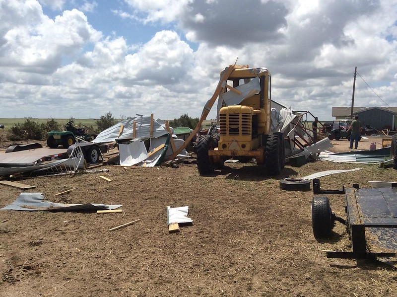
Near Platner though, a more powerful tornado ripped through a farm at about 6:50pm that evening.  The twister lifted a pole barn, destroying it.  Debris was found one mile away.

Wind and hail ripped across an area six miles wide near Akron causing extensive damage.  Farm equipment was toppled and a barn heavily damaged by the wind while houses saw the siding punctured and windows broken from hail.

Below are images taken by the National Weather Service of the area.

[flickr_set id=”72157668536532282″]
Public Information Statement
National Weather Service Denver/Boulder CO
1056 AM MDT THU MAY 26 2016

...NWS DAMAGE SURVEY FOR 05/24/16 TORNADO EVENT... 

.OVERVIEW...A long-lived supercell thunderstorm moved across
eastern Colorado and produced two EF-1 tornadoes and two EF-0
tornadoes in Washington County on May 24, 2016. Widespread wind
and hail damage also occurred, with a swath of damage nearly 6
miles wide at some points east and northeast of Akron.

.Washington County tornado near Platner...

Rating:                 EF-1
Estimated peak wind:    86-110 mph
Path length /Statute/:  0.9 miles
Path width /Maximum/:   20 yards
Fatalities:             0
Injuries:               0

Start date:             May 24 2016
Start time:             650 PM MDT
Start location:         1 mile northeast of Platner / Washington County / CO
Start Lat/Lon:          40.1647 / -103.0467

End date:               May 24 2016
End time:               655 PM MDT
End location:           1 mile east of Platner / Washington County / CO
End_lat/lon:            40.155 / -103.0366

This tornado struck one farm, lofting and completely destroying
a pole shed, and also damaging trees. Power lines were snapped
just to the southeast of the farm.

.Washington County tornado near Yuma County line...

Rating:                 EF-1
Estimated peak wind:    110 mph
Path length /Statute/:  0.1 mile
Path width /Maximum/:   90 yards
Fatalities:             0
Injuries:               0

Start date:             May 24 2016
Start time:             715 PM MDT
Start location:         9 miles north/northwest of Yuma / Washington County / CO
Start Lat/Lon:          40.2350 / -102.7943

End date:               May 24 2016
End time:               716 PM MDT
End location:           9 miles north/northwest of Yuma / Washington County / CO
End_lat/lon:            40.2348 / -102.7936

This tornado struck one farm, destroying a pole shed. Slight roof damage
occurred to the house, along with some tree damage.

.Washington County tornado 1 mile Northeast of Akron...

Rating:                 EF-0
Estimated peak wind:    65-85 mph
Path length /Statute/:  0.0 miles
Path width /Maximum/:   10 yards
Fatalities:             0
Injuries:               0

Start date:             May 24 2016
Start time:             644 PM MDT
Start location:         1 mile southeast of Akron / Washington County / CO
Start Lat/Lon:          40.1490 / -103.1981

End date:               May 24 2016
End time:               644 PM MDT
End location:           1 mile southeast of Akron / Washington County / CO
End_lat/lon:            40.1490 / -103.1981

Brief touchdown with no damage.

.Washington County tornado 1 mile Southeast of Akron...

Rating:                 EF-0
Estimated peak wind:    65-85 mph
Path length /Statute/:  0.0 miles
Path width /Maximum/:   10 yards
Fatalities:             0
Injuries:               0

Start date:             May 24 2016
Start time:             647 PM MDT
Start location:         1 mile northeast of Akron / Washington County / CO
Start Lat/Lon:          40.1708 / -103.1959

End date:               May 24 2016
End time:               647 PM MDT
End location:           1 mile northeast of Akron / Washington County / CO
End_lat/lon:            40.1708 / -103.1959

Brief touchdown with no damage.

EF Scale: The Enhanced Fujita Scale Classifies
Tornadoes into the following categories.

EF0...Weak...... 65 to 85 mph
EF1...Weak...... 86 to 110 mph
EF2...Strong.... 111 to 135 mph
EF3...Strong.... 136 to 165 mph
EF4...Violent... 166 To 200 mph
EF5...Violent... >200 mph*

NOTE:
The information in this statement is PRELIMINARY and subject to
change pending final review of the events and publication in
NWS Storm Data.

Slideshow – Amazing images captured by Storm Chase 2010

A shelf cloud moves across Nebraska farmland. (Tony Hake / ThorntonWeather.com)

Certainly the highlight of storm chasing is tornadoes and ThorntonWeather.com’s Storm Chase 2010 had plenty of those – five in one day in fact.  However, as great of satisfaction can be derived from simpler, less violent storms.  The images from a week of chasing on the Great Plains show the fury and the beauty of Mother Nature.

Storm chasing is as much an art as a science – there are no guarantees that tornadoes will appear as forecast. Other types of severe weather and the amazing structure they display can bu just as impressive.

Scud clouds hovering over a coal train in Nebraska, egg sized hail pummeling storm chaser vehicles, the sun setting on the Oklahoma plains and the now infamous Baca County, Colorado tornado ripping through ranchland all were highlights of Storm Chase 2010.

The images in the slideshow below represent some of the most stunning and beautiful images captured during the week.

Storm Chase 2010 wraps up – Chasers experience it all from sunsets to tornadoes

The Memorial Day tornado in Baca County, Colorado near Campo was the highlight of a week of storm chasing but it wasn’t the only exciting thing to happen. (Tony Hake / ThorntonWeather.com)

We have said before that storm chasing is as much an art as a science and it can very much be feast or famine.  Both extremes were seen over the course of a week of storm chasing on the Great Plains by ThorntonWeather.com.

We hope our site visitors were checking out the Storm Chase 2010 Examiner where we were documenting our chase across America’s heartland.  With stories, photos and video, the entire incredible week has been described in detail.

Two ‘busted’ storm chase days started out the week – one with a round trip from Denver to Nebraska and another one-way to Amarillo, Texas.  Those certainly fulfilled the ‘famine’ part of storm chasing. 

The third day however brought a ‘feast’ in the form of a bounty of five tornadoes in one day.  Chasing storms in southeastern Colorado, ThorntonWeather.com witnessed the entire gamut of severe weather from drenching rain and damaging hail to gale force winds and of course tornadoes. 

The first tornado of that day near Pritchett, Colorado allowed chasers to witness the complete tornado genesis.  As massive amounts of air were sucked into a storm cell and the clouds swirled menacingly above, a small funnel cloud soon grew into a powerful tornado. 

Two other tornadoes and an incredible hail storm on the virtually barren ranchland followed.  The main event was yet to come however. 

About eight miles south of Campo, Colorado, a massive supercell seemed poised to generate a tornado.  Chasers waited anxiously as the sky grew darker on the plains.  A funnel cloud formed and was cheered on as it grew closer to the ground. 

Before long the tornado was on the ground moving at a leisurely 10 mph – its slow pace allowing for plenty of time to capture amazing photos and video of the event.  The Baca County tornado would draw national media attention and will possibly go down as the most picturesque of all twisters during the 2010 tornado season.

While the Memorial Day tornadoes would be the last seen during the week, they were not the last extraordinary weather event witnessed by the storm chasers. 

Storm Chase 2010 intercepted a flying saucer over western Kansas at the end of a very long chase day. (Tony Hake / ThorntonWeather.com)

Two days after the southeastern Colorado tornadoes, chasers witnessed an extraordinary ‘mothership’ supercell near Goodland, Kansas.  The sight of the ‘flying saucer’ slowly moving across the Kansas wheat fields was extraordinary.

Central Nebraska proved to be the backdrop for another day of weather beauty.  Waiting patiently at a small town gas station, multiple super cells moved across the area and chasers were on the move.  From highways to dirt roads, the chasers saw the storms generate amazing shelf clouds and funnel clouds.

In the end, the group of storm chasers covered over 2,500 miles across five states.  They witnessed many funnel clouds and amazing storm structures and of course five tornadoes, two of which were at close range.  For many it was truly a once in a lifetime experience that allowed them to see Mother Nature’s fury up close and personal.   

Complete stories, photos and video from Storm Chase 2010:

4.1 magnitude earthquake rattles northern New Mexico and southern Colorado

A magnitude 4.1 earthquake struck northern New Mexico early Monday morning.  The temblor was felt as far away as Trinidad, Colorado. (USGS)
A magnitude 4.1 earthquake struck northern New Mexico early Monday morning. The temblor was felt as far away as Trinidad, Colorado. (USGS)

A magnitude 4.1 earthquake struck northern New Mexico west of Raton early this morning and was felt as far away as Trinidad, Colorado. The U.S. Geological Survey says that the temblor’s epicenter was 16 miles west of Raton and originated 3.1 miles underground.

No damage from the quake that occurred at 1:41am on Monday morning has been reported. While a magnitude 4.1 quake is not a major quake, had it struck in a more densely populated area it would have been sufficient to knock items off of shelves.

While normally not particularly active, there are approximately 100 potentially active faults in Colorado and more than 400 temblors of magnitude 2.5 have occurred in the state since 1870. The state’s largest quake occurred on November 7, 1882 along the northern Front Range and measured 6.5 on the Richter Scale.

According to the Colorado Division of Emergency Management, the costliest quake was a 5.3 magnitude temblor that occurred on August 9, 1967 and was centered near Commerce City. The quake caused more than $1 million worth of damage and is thought to have been caused by the injection of liquid waste into the earth at the Rocky Mountain Arsenal.

The Sangre de Christo Fault, near which the quake occurred, is located in the mountain range for which it is named and runs more than 110 miles from the New Mexico border north into Colorado. In 2001 an earthquake “swarm” shook the area near Trinidad on the fault. During that event, from August 28 and September 21 of that year, 12 earthquakes of magnitude 2.8 to 4.6 struck just west of the southern Colorado city in the same area as Monday’s quake.

In October of this past year, magnitude 4.1 and magnitude 3.5 quakes struck not far from this morning’s quake. Prior to that, in August, three quakes in four days struck, one in southeastern Colorado and two in the northwestern part of the state.