Insane dashcam video of a man driving through the EF-3 tornado that struck Clarksville, Tennessee on Saturday. Six people were killed in the series of storms. Read the National Weather Service’s summary of the event here.
December 10 to December 16: This week in Denver weather history

This time of year snow is a common occurrence but in our look back at this week in Denver weather history we are struck by the lack of significant snow events in the history books for the period. What we do see instead are a number of high wind events, many of which caused widespread damage.
From the National Weather Service:
2-17
In 1939…more than 2 weeks of unseasonably warm weather made the month the 3rd warmest on record. Seven daily temperature records were set…including the all time record high temperature for the month of 79 degrees on the 5th. Daytime highs were balmy with 14 days in the 60’s and 70’s. Low temperatures dipped to freezing or below on only 5 days. The period was dry with only a trace of snow on the 12th.
3-15
In 1972…a protracted cold spell held an icy grip on metro Denver when maximum temperatures never reached above freezing for 10 consecutive days from the 3rd through the 12th and minimum temperatures dipped below zero on eleven consecutive days from the 5th through the 15th. Daily low temperature records were set with 15 degrees below zero on the 5th…17 degrees below zero on the 6th… And 18 degrees below zero on the 10th. Daily record low maximum readings were set with 3 degrees on the 6th and 6 degrees on the 9th. The very cold temperatures were caused by 3 to 5 inches of snow cover and a Canadian air mass.
8-12
In 1932…the second longest sub-zero period on record in Denver occurred. The temperature fell below zero shortly after 1:00 pm on the 8th and remained below zero for 92 hours until 9:00 am on the 12th. The lowest temperature recorded during this period was 13 degrees below zero on both the 9th and 11th. That temperature on the 11th was a record low for the date. High temperatures of 4 on the 8th…5 below zero on the 9th…1 below zero on the 10th… And 6 below zero on the 11th were record low maximum temperatures for those dates. Light north winds at 5 to 10 mph were accompanied by occasional light snow…which totaled only 2.2 inches.
9-13
In 1961…cold arctic air produced a protracted cold period. The temperature plunged to 16 degrees below zero on the 10th…establishing a new record for the date and the coldest reading since 25 degrees below zero on February 1… 1951. Low temperatures dipped below zero on 5 consecutive days with 9 degrees below zero on the 9th…16 below on the 10th…10 below on the 11th…and 12 below on both the 12th and 13th. High temperatures reached only 3 degrees on the 10th and 6 degrees on the 11th.
10
In 1953…snowfall totaled 3.8 inches at Stapleton Airport where northeast winds were sustained at speeds to 47 mph and gusted to 60 mph behind a cold front.
In 1969…sustained winds of 30 mph with gusts to 55 mph in downtown Boulder caused minor damage. Northwest winds gusted to 39 mph at Stapleton International Airport.
In 1980…winds to 60 mph whistled through Boulder.
In 1987…strong winds in the foothills spread over northern portions of metro Denver. Wind gusts of 60 to 75 mph were common in Boulder and southwestern weld counties. However… The highest reported wind gust…94 mph…occurred near Rollinsville. A northwest wind gust to 36 mph was recorded at Stapleton International Airport.
10-11
In 1933…downslope winds produced warm temperatures…resulting in record high minimums of 46 degrees on the 10th and 44 degrees on the 11th. High temperatures of 66 degrees on the 10th and 62 degrees on the 11th were not records. Southwest winds were sustained to 16 mph on the 10th.
In 1939…high temperatures of 70 degrees on the 10th and 74 degrees on the 11th were record maximums for the dates. The low temperatures of 39 degrees on the 10th and 41 degrees on the 11th were not records.
In 1948…high winds in Boulder and Louisville caused 1750 dollars in damage. Wind gusts in excess of 70 mph were reported at Valmont and Boulder airport. Chinook wind gusts to 60 mph briefly reduced the visibility to 1/4 mile in blowing dust at Stapleton Airport.
In 1989…the season’s greatest snowfall to date hit metro Denver with 6 to 12 inches of snow. Flight delays at Stapleton International Airport reached 2 hours. Multiple wrecks snarled traffic on I-25 both north and south of the city. Snowfall totaled 7.0 inches at Stapleton International Airport where north winds gusted to 25 mph on the 10th.
11
In 1938…snowfall totaled 3.7 inches in downtown Denver. North winds were sustained to 21 mph with an extreme velocity to 22 mph.
In 1967…wind gusts to 58 mph in downtown Boulder caused minor damage. Northwest winds gusted to 47 mph at Stapleton International Airport.
In 1980…winds to 60 mph were reported in Boulder. Northwest winds gusted to 23 mph at Stapleton International Airport. The Chinook winds warmed temperatures to a high of 67 degrees.
In 1994…strong gusty winds occurred along the Front Range eastern foothills. A wind gust to 67 mph was recorded in Boulder with a gust to 58 mph measured at Jefferson County Airport near Broomfield. No damage was reported. Northwest winds gusted to 31 mph at Stapleton International Airport.
11-12
In 1903…a sharp cold front on the 11th plunged temperatures from a high of 59 degrees to a low of 15 degrees…produced northeast winds sustained to 42 mph along with gusts as high as 60 mph…and produced 1.3 inches of snow overnight. The high temperature on the 12th was only 25 degrees.
In 1968…strong winds buffeted the eastern foothills and plains and caused light…but widespread property damage. Wind gusts of 50 to 75 mph were reported. West winds gusted to 52 mph at Stapleton International Airport.
11-13
In 1940…5.4 inches of snow fell across downtown Denver. This was the only snowfall of the month. Temperatures were quite cold on the 13th with a high of 6 degrees and a low of 2 degrees below zero.
In 1984…up to 6 inches of new snow fell over metro Denver… Hampering flight operations at Stapleton International Airport where snowfall totaled 3.8 inches and east winds gusted to 25 mph on the 11th. Continue reading December 10 to December 16: This week in Denver weather history
November 2023 weather recap: Thornton gets another mild, dry month
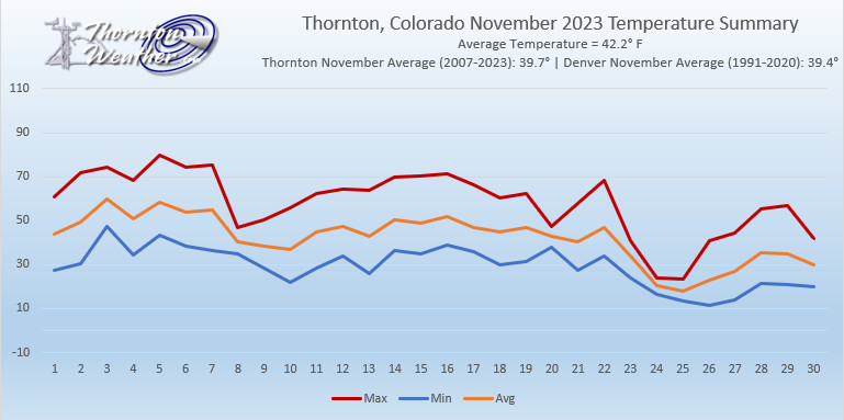
For the second month in the row, Thornton saw a period of temperatures above normal and precipitation below normal. Were it not for a cold snap and snow to end the month, it would have been much worse.
Most of November saw a continuation of the mild, dry weather we saw in October. For the first three weeks, temperatures were largely above normal and precipitation was virtually non-existent. In fact, 19 out of the first 22 days of the month saw mercury readings above normal and a mere 0.02 inches had been recorded in the rain bucket and we had no snow.
Mother Nature finally changed course and chilled us out and brought our first snow of the month during the last week. We saw a few days with well below normal temperatures and 4.3 inches of snowfall were recorded over a two-day period.
Thornton’s average temperature for November 2023 came in at 42.2 degrees. This was well above our 17-year running average for November of 39.7 degrees. Temperatures ranged from a high of 79.8 degrees on the 5th down to a low of 11.7 degrees on the 26th.
Out at DIA where the Mile High City’s official measurements are taken, it was similarly warm. Denver had an overage temperature for the month of 43.2 degrees, again, well above their average of 39.4 degrees.
In terms of precipitation, Thornton saw a mere 0.20 inches of liquid precipitation during the month. This was less than half of the 0.47 inches running November average and tied for the third driest November of the past 17 years.
Denver recorded 0.18 inches out at the airport. Far below their long term November average of 0.64 inches.
Snow was below normal both here in Thornton and at DIA. Thornton recorded 4.3 inches, a good bit below the 5.7 inch November average of the past 17 years. Denver saw less than us with 2.9 inches, far below their long term November average of 7.3 inches.
Click here to view Thornton’s complete November 2023 climate summary report.

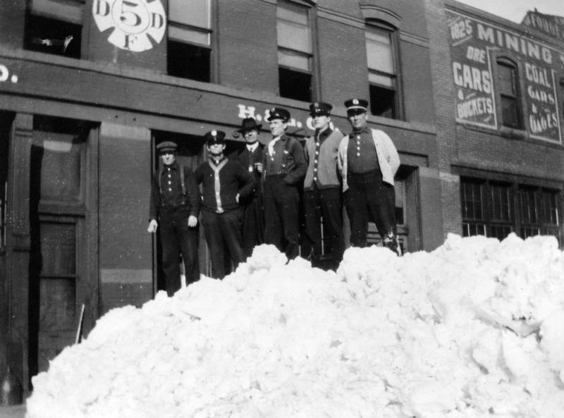
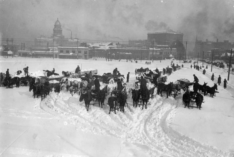
110 years ago: Looking back at the Great Colorado Snowstorm of 1913

Significant snow events in Colorado are not unusual however some are nothing short of epic. Such was the case with the Great Colorado Snowstorm of 1913, a storm that occurred 110 years ago today and still stands as the largest snow event in Denver history.
It was a classic setup. Low pressure to Colorado’s southwest slowly moved to the northeast drawing in moist air – and dropping snow along the Front Range.
The first three days of the storm were relatively calm with Denver only seeing 8 inches. On the 4th and 5th however Mother Nature let loose with 37.4 inches of snow.
- Scroll down to view some photos from the monstrous storm
- National Weather Service Poster about the 1913 Snowstorm (PDF)
The total for the event, 45.7 inches, was and still is the heaviest single snowfall event in Denver history. To the west, Georgetown recorded an even more amazing 86 inches, 63 of which fell on the 4th of the month alone.
The Denver Post headline on December 5, 1913 read, “Denver in Mantle of Shimmering White, Stops Activity and Everybody Jollifies.”
A subheading said, “All Denver is Waking Amid Ghostly Silence of Streets That Are Buried – Whole State Fells Storm of Varying Intensity.”
The Post’s now defunct competitor, the Rocky Mountain News, saw a silver lining. Its headline read, “Colorado Gripped by Worst Snowstorm Recorded in 28 Years; Denver is Hit Hard, but Blizzard Means Millions in Crops.”
Indeed, in a day long before four wheel drive existed and when horse and carriage were as common as cars, the storm had a tremendous impact.
Travel was brought to a complete halt in the area as snow drifts blocked all roads. Trolleys were unable to run downtown and railroads in and out of the city were stopped. It would be a week before streetcar service was returned to normal.
Stranded workers were housed at the city auditorium, jail and movie theatres. Telegraph, telephone and electrical service were interrupted as the snow downed lines across the area. Schools were closed at the height of the storm and some remained shuttered for days.
Any open space in the city became a snow dumping ground as the city dug out. The Rocky Mountain News reported that anyone needing work could help the Tramway company with snow removal. Pay was $3.50 per day.
Despite the ferocity of the storm, accounts of the day indicate only a few fatalities. Dozens of buildings did collapse under the sheer weight of the snow.
The Great Colorado Snowstorm coupled with smaller events over the rest of the month yielded a snowfall total for December 1913 of 57.4 inches, the snowiest month ever recorded in Denver. Additionally, 5.21 inches of precipitation was recorded making the month the wettest December on record.


Thornton’s December 2023 preview: Winter arrives, typically with cold and snow

Recent months have, overall, been warmer and drier than normal. Last month initially brought more of the same but then took a turn toward colder temps and offered up some much-needed snow. What will December hold for us?
The month of December brings with it the official start of winter and oftentimes, colder and snowier weather conditions. It, however, can also offer unseasonably warm temperatures and bone dry conditions. Given our recent mild and dry weather, we are certainly hoping for a change in the coming month.
Overall December’s monthly mean temperature of 31.2 degrees (1991 – 2020 averages) makes it our coldest month. Snow is always on everyone’s mind this time of year but December is only our 3rd snowiest month behind March and November with an average of 8.0 inches of the white stuff.
December 3 to December 9: This week in Denver weather history
Wind and big time snowstorms can visit the Mile High City this time of year and we see many such events in our look back at this week in Denver weather history. Probably most notable, the Blizzard of 1913, the Mile High City’s biggest snowstorm in history.
From the National Weather Service:
1-5
In 1913…the 1st marked the start of the heaviest 5-day total snowfall in the city’s history. During this period snowfall totaled 45.7 inches. Starting on the 1st…snow fell intermittently for 3 days and accumulated a little over 8 inches. On the 4th and 5th…an additional 37.4 inches of snow fell. At Georgetown in the foothills west of Denver even more snow fell…86 inches over the 5 days with the most…63 inches…on the 4th. In Colorado…snowfall was heavy along the eastern slopes of the mountains from the Palmer Divide north. High winds during the storm caused heavy drifting…which blocked all transportation. Snow cover of an inch or more from the storm persisted for 60 consecutive days from the 1st through January 29…1914. Additional snowfall in December and January prolonged the number of days. This is the third longest period of snow cover on record in the city.
2-3
In 1955…snowfall totaled only 2.9 inches at Stapleton Airport. This was the only measurable snowfall of the month.
In 1973…post-frontal heavy snowfall totaled 7.6 inches at Stapleton International Airport where northeast winds gusting to 37 mph caused some blowing snow.
In 1990…strong downslope winds raked the eastern foothills and most of metro Denver. A wind gust to 87 mph was recorded at Rollinsville with wind gusts to 58 mph in Arvada and 55 mph in Lakewood. West winds gusted to 48 mph at Stapleton International Airport on the 2nd.
In 1997…heavy snow fell in the foothills. Conifer received 10 inches of new snow. Snowfall totaled only 2.4 inches at the site of the former Stapleton International Airport on the 1st…2nd…and 3rd. North winds gusted to 24 mph at Denver International Airport on the 2nd.
2-4
In 1909…post-frontal snowfall totaled 6.1 inches in downtown Denver. Most of the snow…5.9 inches…fell between 6:00 pm on the 2nd and 6:00 pm on the 3rd. North winds were sustained to 18 mph on both the 2nd and 3rd.
2-17
In 1939…more than 2 weeks of unseasonably warm weather made the month the 3rd warmest on record. Seven daily temperature records were set…including the all time record high temperature for the month of 79 degrees on the 5th. Daytime highs were balmy with 14 days in the 60’s and 70’s. Low temperatures dipped to freezing or below on only 5 days. The period was dry with only a trace of snow on the 12th.
3
In 1977…high winds continued in Boulder and were clocked from 74 to 90 mph…causing only minor damage. Northwest winds gusted to 33 mph at Stapleton International Airport where the strong Chinook winds warmed the temperature to a high of 63 degrees.
In 1985…wind gusts to 78 mph were clocked at Table Mesa in Boulder. Winds gusted to 70 mph at Echo Lake west of Denver.
In 2011…Another round of snow developed in and near the Front Range Foothills. The heaviest snowfall occurred in the foothills of Boulder and northern Jefferson Counties. Storm totals included: 13 inches…7 miles southwest of Boulder; 10.5 inches…4 miles east-northeast of Nederland; 10 inches at Genesee; 9.5 inches…4 miles west-northwest of Boulder; 9 inches at Gross Reservoir and 4 miles east of Pinecliffe. Around the Urban Corridor…storm totals ranged from 3 to 8 inches…heaviest in and around Boulder.
3-4
In 1968…strong Chinook winds in Boulder gusting to 52 mph downtown caused 7 thousand dollars in damage. Flying debris damaged cars…houses…and other property in Boulder. West winds gusted to 49 mph late on the 3rd and to 45 mph on the 4th at Stapleton International Airport where the temperature climbed to a high of 60 degrees on the 4th.
In 1970…strong winds whistled through Boulder. Sustained winds of 40 mph with gusts to 70 mph were recorded at the National Bureau of Standards in Boulder. Wind gusts to 50 mph occurred in downtown Denver. No damage was reported. On the 3rd…northwest winds gusted to 40 mph at Stapleton International Airport where the Chinook winds warmed the temperature to a high of 66 degrees on the 4th.
In 1999…heavy snow fell over the foothills and metro Denver. The heaviest snowfall occurred in the foothills south of I-70 and near the Palmer Divide. Snowfall totals included: 25 inches near Tiny Town; 18 inches at Conifer; 15 inches near Evergreen; 14 inches at Chief Hosa…8 miles west of Castle Rock…and near Blackhawk; 12 inches at Pine Junction and 8 miles south of Sedalia; 11 inches atop Floyd Hill and in Roxborough; and 10 inches at Castle Rock. Around metro Denver…snowfall totals included: 10 inches at Highlands Ranch…9 inches at Parker…and 8 inches in Aurora and Wheat Ridge. Elsewhere around the metro area…snowfall generally ranged from 3 to 5 inches. Only 3.2 inches of snow fell at the site of the former Stapleton International Airport. North winds gusted to 32 mph at Denver International Airport on the 3rd.
In 2007…high winds developed in and near the Front Range foothills. Peak wind reports included: 88 mph atop Niwot Ridge; 87 mph atop mines peak; 80 mph…3 miles southeast of Jamestown; 78 mph at Longmont; 74 mph at Table Mesa. A few power outages occurred in Longmont as broken branches downed power lines. Northwest winds gusted to 38 mph at Denver International Airport on the 4th.
In 2013…a storm system brought heavy snow to parts of the Front Range Foothills. Storm totals included: 12 inches…7 miles west-southwest of Evergreen; 10.5 inches…3 miles north of Bailey; 9.5 inches…3 miles west of Jamestown and 5 miles northeast of Ward; 9 inches in Bailey…8.5 inches… 3 miles north of Conifer. Continue reading December 3 to December 9: This week in Denver weather history
Wednesday offers up one more relatively mild day in Thornton

Another nice, late fall day is in store for us today. We again will have lots of sun and mercury readings above average.
Sunny skies will be the general rule although there may be a cloud here or there. Conditions will remain calm and dry. High temperatures will again top out in the mid-50s.
Tonight, a cold front pushes through leading to increasing clouds. Lows will dip to around 20 degrees.
Going forward, we can expect cooler weather for the next couple of days. More in the extended forecast here.
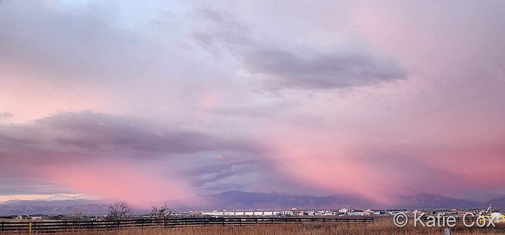
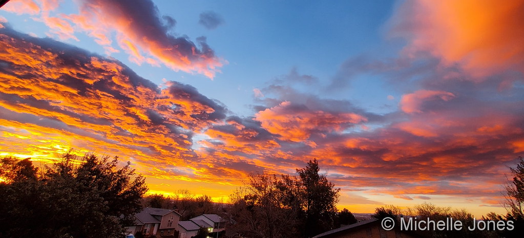
November 2023 top shots: Monthly photo slideshow

Typically November is a quiet weather month with plenty of nice, fall days but it can also turn wet with healthy doses of snow and moisture. The wide variety of conditions can create picturesque scenes ranging from blue skies and snow-capped mountains to a wintry wonderland in the metro area.
November is the second snowiest month of the year so winter conditions are not unusual. Typically though, these bouts of cold are short-lived and normal daytime conditions are pleasant.
Outdoor activities continue to be quite popular during the month. The cooling temperatures do oftentimes lead to an increase in wildlife activity.
All of the above help lead to a month in which a wide variety of scenes, flora and fauna can be captured.
- Slideshow updated November 28, 2023
- To learn more about how to send your photo to us for inclusion in the slideshow, see below the slideshow.
Showcasing images captured by ThorntonWeather.com readers as well as some of our own, our monthly slideshow covers the entire gamut of weather-related imagery.
Sunsets, sunrises, wildlife and of course every type of weather condition are vividly depicted in images captured from yours and our cameras.


|
What is missing in the slideshow above? Your photo!
Our monthly photo slideshow is going to feature images that we have taken but more importantly images that you have captured. The photos can be of anything even remotely weather-related.
Landscapes, current conditions, wildlife, pets, kids. Whimsical, newsy, artsy. Taken at the zoo, some other area attraction, a local park, a national park or your backyard. You name it, we want to see and share it!
Images can be taken in Thornton, Denver or anywhere across the extraordinary Centennial State. We’ll even take some from out of state if we can tie it to Colorado somehow.
We’ll keep the criteria very open to interpretation with just about any image eligible to be shown in our slideshows.
What do you win for having your image in our slideshow? We are just a ‘mom and pop’ outfit and make no money from our site so we really don’t have the means to provide prizes. However you will have our undying gratitude and the satisfaction that your images are shared on the most popular website in Thornton.
To share you images with us and get them included in the slideshow just email them to us or share them with ThorntonWeather.com on any of the various social media outlets. Links are provided below.
So come on, get those camera’s rolling!
- Email: info@ThorntonWeather.com
- Facebook: https://www.facebook.com/ThorntonWeather
- Twitter: @ThorntonWeather (https://twitter.com/thorntonweather)
Thornton Weather launches major site redesign
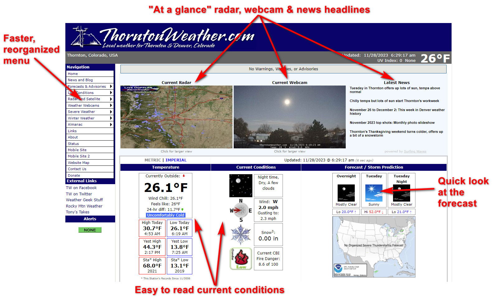
It was October 2006 when ThorntonWeather.com first went online and we are proud to be the city’s longest running, most reliable and most comprehensive weather website (more about us here).
Since then, we have had a few different designs, and we are proud to launch our latest. There is a lot to take in but front and center is our revamped main page.
Among the highlights:
- See everything essential ‘above the fold’ without scrolling including…
- Current radar, webcam and the latest news right up top for easy reference
- Easy to read current conditions so you know exactly what is going on at that moment
- A much-requested feature, a ‘quick look’ at the weather forecast, up top and easy to see
- The main menu uses new coding that is much more responsive
- Scrolling down, the main page dashboard has comprehensive conditions and statistics, enough to satisfy any weather geek
There is much more as you click through the various pages (including new mobile pages!) that we will highlight in the coming days and we do still have more work to do. Until then, hop on and take a look! Go: https://www.thorntonweather.com/
Tuesday in Thornton offers up lots of sun, temps above normal

A nice recovery from the recent chill is in store for us today and tomorrow. Look for lots of sun above and temps a good bit above normal.
Sunny skies will be with us throughout the day. Conditions will be calm and dry. High temperatures will be topping out in the low to mid-50s.
Tonight, lows will dip to around 20 degrees under mostly clear skies.