Avalanche safety – Be prepared or die

Avalanches claim lives every year in Colorado. Before you head to the mountains, be sure you are prepared! (Wikimedia Commons)

As snow starts to fall, many Coloradoans and out of state visitors will take advantage of it and head to the mountains for a variety of outdoor activities.  Whether skiing, snowshoeing, or hiking, anyone who spends time outdoors in the high country needs to be aware of the danger avalanches present.  On average six people die in Colorado every year from avalanches and being prepared is an essential survival skill.

In this fifth in a series on Winter Weather Preparedness from the National Weather Service, ThorntonWeather.com helps you understand avalanches, where they occur, how to protect yourself and where to go for more information.  If you are headed to the high country, be sure to check out our Avalanche Information & Forecast page.

PUBLIC INFORMATION STATEMENT
NATIONAL WEATHER SERVICE DENVER CO
600 AM MDT FRI OCT 21 2022

Avalanches – Are you prepared?

Thousands of avalanches occur each winter in the mountains of Colorado. With the enormous popularity of winter sports in Colorado, this poses a risk to skiers, snowboarders, snowmobilers, and people traveling in the backcountry. On average 6 people die in Avalanches in the state of Colorado every year. Anyone who travels into the high country in the winter should be prepared for avalanches And know how to avoid them.

The most important thing to know is how to get information on current avalanche conditions. Check the Colorado Avalanche Information Center website at http://avalanche.state.co.us/ for the current avalanche forecast and the National Weather Service website http://www.weather.gov for the current weather forecast in your area. Knowing the current and future conditions will help you make good decisions in the backcountry.

A little information about avalanche safety can go a long way. Most avalanches occur during or just after snowstorms on a slopes between 30 to 45 degrees. A significant snowfall may result in an unstable snowpack. By waiting at least 36 hours after a big snow or wind storm before you go into the mountains the Snow may become more stable and less likely to avalanche. If you stay in valleys away from avalanche chutes, in stands of dense trees, or on gentle slopes you can decrease the risk of being caught in an avalanche.

If you are a skier or snowboarder at a commercial ski area the risk from avalanches is lower than in the backcountry. Ski patrols work to reduce the chance of an avalanche on open slopes. Respect the rules of the ski area, stay on open slopes, and do not stray out of bounds or into closed areas. The avalanche risk is higher outside of the ski area boundaries.

If you want to enjoy the great outdoors in areas prone to avalanches…You can reduce the danger by following a few simple rules:

  • Check the current avalanche forecast to get information on current and forecast avalanche conditions. Also check the latest weather forecast to see if conditions are likely to change while you are in the backcountry.
  • Never travel alone. Always have one or more companions. Even small avalanches can be fatal. If you are alone and get trapped, you may not be found until spring.
  • If crossing a slope that may be prone to avalanches, do it one person at a time. You want to minimize the impact on your party if an avalanche is accidentally released.
  • In avalanche country, all members of your party should carry avalanche rescue equipment including an avalanche beacon, shovel and probe pole. This increases your chances of a successful rescue and finding your friends alive.

Avalanche conditions in Colorado are monitored and forecasted by the Colorado Avalanche Information Center, CAIC. You can get more information on avalanches, avalanche forecasts, avalanchesafety and request a safety class from CAIC. Go to their website…Http://www.colorado.gov/avalanche or call the center at 303-499-9650.

Winter Weather Preparedness Week continues through Saturday. Now is the time to get prepared for winter so you can safely enjoy the outdoors and travel safely when the snow flies.

Avalanche Safety Tips

Life threatening winter weather – Wind chill, frostbite and hypothermia

Wind chill is a life threatening weather danger that is often ignored or underestimated. (AP Photo)
Wind chill is a life threatening weather danger that is often ignored or underestimated.

Winter weather can not only be trying on the mind and soul, it also presents very real dangers to the human body.  Extreme wind chills can be deadly and bring on the outset of frostbite and hypothermia.  Here in Colorado, all residents should be aware of these hazards and be prepared to deal with them.

In this fourth in a series on Winter Weather Preparedness from the National Weather Service, ThorntonWeather.com helps you understand wind chill and how to protect yourself from frostbite and hypothermia.

PUBLIC INFORMATION STATEMENT
NATIONAL WEATHER SERVICE DENVER/BOULDER CO
600 AM MDT THU OCT 20 2022

Extreme wind chill – Potentially life-threatening and often overlooked

Extremely cold air comes every winter in at least part of the country and affects millions of people across the United States. The arctic air, combined with brisk winds, can lead to dangerously cold wind chill values. The Wind Chill Index helps you determine when dangerous conditions develop that could lead to frostbite or hypothermia. It takes into account heat loss from the human body to its surroundings during cold and windy weather. The calculation utilizes wind speed in miles per hour and temperature in degrees Fahrenheit. For example, a temperature of minus 5 degrees occurring with a 20 mph wind gives a wind chill near minus 30 degrees. This means that your body will lose heat at the same rate as it would if the air temperature were minus 30 degrees with no wind. Wind Chill values near minus 25 degrees mean that frostbite is possible within 15 minutes.

  • How does the wind affect wind chill?  See the chart below.

Frostbite is the freezing of skin and the body tissue just beneath it. It first affects exposed body tissue where blood circulation may be limited such as your fingers, toes, nose and ears. To minimize frostbite, make sure all body parts are well covered. When frostbite starts, feeling is lost in the affected area and the frozen tissue will take on a white or pale appearance. If you suspect you are experiencing frostbite, hold the frostbitten area closely against warm skin to return blood flow and warmth to the affected area.

Hypothermia is a dangerously low body temperature and is the most common winter weather killer. When you hear of a hiker, climber, hunter or a stranded traveler perishing from cold weather exposure, hypothermia was the cause. Most people are surprised to learn that hypothermia deaths can occur with temperatures between 30 and 50 degrees. If you or your clothing are wet, then hypothermia becomes even more likely.

Warning signs of hypothermia include uncontrollable shivering, memory loss, disorientation, slurred speech and drowsiness. Immediate medical attention should be given to victims suspected of suffering from hypothermia. If no help is available, the victim should be warmed slowly with warm liquids along with dry clothing and blankets.

The National Weather Service will issue wind chill advisories and warnings when a deadly combination of wind and cold air threaten. A Wind Chill Warning will be issued for the following wind chill temperatures:

  • Mountains…minus 35 degrees Fahrenheit or colder.
  • Lower Elevations…minus 25 degrees Fahrenheit or colder.

When cold weather threatens, follow these tips for survival:

  • Stay dry, wet clothing results in much faster heat loss from your body. Wear waterproof insulated boots.
  • Stay covered, wear mittens or gloves and wear a hat. At least half of your body heat is lost if your head is not covered.
  • Dress layered, trapped air between loose fitting clothing helps to insulate.
  • Stay informed, have a portable NOAA weather radio nearby to keep you up-to-date with the latest forecasts and warnings. Use wind chill temperatures to guide you in dressing properly for the outdoors. On very cold days, minimize your exposure to the outdoors if possible.

Winter Weather - Extreme Cold Safety

Winter Weather - Signs of Hypothermia

Wind Chill Chart

High winds a major threat in Colorado during the winter

Winter winds can not only make it miserable to be outside, they can also be dangerous.

As we often experience, high winds in Colorado can cause conditions to deteriorate rapidly.  They present a very real danger to life and property, especially when coupled with other winter conditions like snow.

Why does it seem like we get so much wind in the winter?  What causes this?  How can you prepare and protect yourself and your property?

In this third in a series on winter weather preparedness from the National Weather Service, ThorntonWeather.com helps you understand why we receive so much wind and how to prepare for it.

PUBLIC INFORMATION STATEMENT
NATIONAL WEATHER SERVICE BOULDER CO
ISSUED BY NATIONAL WEATHER SERVICE PUEBLO CO
600 AM MDT WED OCT 19 2022

…WIDESPREAD HIGH WINDS VISIT COLORADO DURING THE WINTER…

This week through October 22nd is Winter Weather Preparedness Week in Colorado.

The two main causes of high winds in Colorado during the cold season are the air pressure difference between strong low pressure and cold high pressure systems, and Chinook winds developing across the Front Range and other eastern mountain ranges.

Continue reading High winds a major threat in Colorado during the winter

Winter weather – What does that weather warning mean?

You have seen and heard the warnings but do you know what they really mean?

We all are familiar with the crawls on the TV screen or the announcements on the radio for winter weather advisories such as Winter Storm Watch, Blizzard Warning, Freeze Warning and more. But, how many of us really know what those mean? There is very specific criteria the National Weather Service follows in issuing these watches and warnings and there are important differences between all of them.

In this second in a series on Winter Weather Preparedness from the National Weather Service, ThorntonWeather.com helps you understand what all of these mean so you can be better prepared.

PUBLIC INFORMATION STATEMENT
NATIONAL WEATHER SERVICE BOULDER CO
600 AM TUE OCT 18 2022

From the National Weather Service:

What does that warning mean?

When a warning is issued during the winter season, will you know what it means, and will you know how to respond? During this Colorado Winter Weather Preparedness Week, please become familiar with our list of potentially life-saving winter weather products.

OUTLOOKS

A Hazardous Weather Outlook is issued daily by the National Weather Service office in Boulder Colorado. The outlook provides information on potentially hazardous weather out to 7 days into the future. Also, the Weather Story, a graphic of expected hazardous weather, is posted daily on National Weather Service web sites.

WATCHES AND WARNINGS

A Winter Storm Watch is issued when hazardous winter storm conditions are possible within the next 3 to 4 days, but the timing, intensity, or occurrence may still be uncertain. In contrast, a Winter Storm Warning is issued for potentially life-threatening winter storm conditions, such as heavy snowfall or a combination of snowfall and blowing snow, which are likely to occur within the next 1 to 2 days. Impacts such as timing of winter weather on rush hour are also considered when issuing Watches and Warnings.

Winter Storm
Plains: 6″ in 12 hours, 8″ in 24 hrs
Mountains: 8″ in 12 hours, 12″ in 24 hours
And Impacts

Winter Weather Advisory
Plains: 3-6″ in 12 hours, 4-8″ in 24 hours
Mountains: 4-8″ in 12 hours, 6-12″ in 24 hours
And Impacts

Blizzard
Sustained wind or frequent gusts 35 mph or greater, AND
Considerable falling/blowing snow with visibility less than 1/4 mile, for at least 3 hours

ADVISORIES

Advisories for winter weather are issued for potentially hazardous conditions which are considered more of a nuisance than a life-threatening situation. However, if caution is not taken the advisory events could become life-threatening. Impacts such as timing of winter weather on rush hour are also considered when issuing Advisories.

Winter Weather Preparedness Week in Colorado will continue through Saturday.

Winter weather watches and advisories.

Winter travel safety – Ensure you and your vehicle are ready

Are you and your vehicle ready for the winter weather ahead?

Before hitting the road, Coloradans need to ensure that they and their vehicles are prepared should inclement weather strike.

ThorntonWeather.com presents the first in a series from the National Weather Service (NWS) as part of Winter Weather Preparedness Week has declared by Colorado’s Governor.  Check back throughout the week for more winter preparedness stories.

Today’s message from the NWS highlights the importance of having a proper emergency kit in your vehicle and should the worst-case scenario occur where you get stuck, what you should do to survive.

PUBLIC INFORMATION STATEMENT
NATIONAL WEATHER SERVICE GRAND JUNCTION CO
601 AM MDT MON OCT 17 2022

Winter Travel Safety

Winter Weather Preparedness Week continues through Saturday October 23rd. Preparedness is a big part of this campaign. Before winter weather arrives in earnest, it is highly recommended that you prepare your car or truck for winter travel. This includes a winter survival kit and good snow tires.

Before winter weather arrives in earnest, it is highly recommended that you prepare your car or truck for winter travel.

A well-equipped vehicle has adequate tires, tire chains, tow rope, sand or cat litter for traction, shovel, tool kit, windshield scraper and brush, battery cables, first aid kit, flashlight, extra batteries, blankets and/or sleeping bags, extra clothing, candles, waterproof matches, jug of water, high calorie packaged food for quick energy, and an empty can to melt snow for drinking.

And during winter weather events, the best way to prevent treacherous winter travel is to avoid it. This can be done by staying informed about current weather and road conditions as well as the latest weather forecasts. Information on road conditions in Colorado is available on the web at www.cotrip.org or from the toll free number 1-877-315-7623. When calling from anywhere in Colorado, dialing 511 will also access the Colorado road reports. Additionally, a free smartphone application, CDOT Mobile, is available.

If you should become stranded during a winter storm, stay with your vehicle and do not panic. If accompanied by others, take turns sleeping. Run the motor every hour for about ten minutes to maintain warmth, but keep windows open a little to prevent the buildup of carbon monoxide. Make sure the exhaust pipe is not blocked. Keep the car visible with brightly colored cloths tied to the side view mirrors, door handles, or external antenna. At night, turn on the dome light when running the engine. Exercise periodically by vigorously moving arms, legs, toes and fingers.

In the mountains, avalanches become a possibility in the winter, especially below steep slopes. Avalanches occasionally come down across roads, with little or no warning. However, avalanche control work is performed on many avalanche prone roads in Colorado, making the roads safer to travel. Caution is advised when traveling along avalanche prone roads, especially during and shortly after a heavy snowstorm, as well as during periods of rapid snowmelt.

Very strong downslope winds occur at times mainly along the front range of Colorado. These Chinook and Bora winds can have gusts exceeding 100 mph. Persons planning travel in lightweight or high-profile vehicles should avoid travel during these strong wind events especially on north-south oriented roads.

Roads which appear to be clear in the wintertime may actually be coated with a thin layer of ice, commonly known as black ice. This nearly invisible ice layer can cause you to rapidly lose control of your vehicle. Black ice is most common during the nighttime hours. If you detect black ice you should reduce your speed.

Please follow these winter travel safety recommendations which could save your life.


Winter Weather Awareness Week - Winter Travel Safety. (National Weather Service)
Winter Weather Awareness Week – Winter Travel Safety. (National Weather Service)


October 16 to October 22: This Week in Denver Weather History

This Week in Denver Weather History

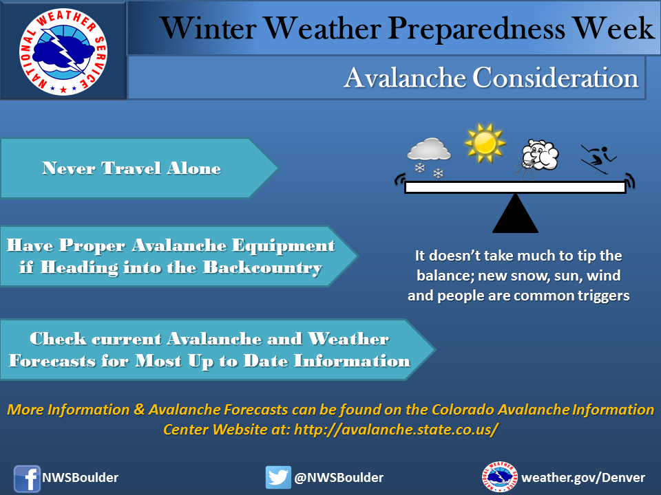
Snow and wind are two common conditions we see this time of year and our look back at this week in Denver weather history certainly has those type of events. Also notable is a surprising October hail storm 13 years ago that went into the books as one of the costliest in history.

From the National Weather Service:

13-16

In 1873…smoke from several large forest fires in the mountains made the air very hazy in the city.

15-16

In 1928…a thunderstorm produced hail shortly after midnight on the 15th. Rain changed to snow by evening. Through the afternoon of the 16th…the heavy snowfall totaled 7.3 inches in the city. North winds were sustained to 23 mph on the 15th.

In 1984…the heaviest October snowstorm in several years hit eastern Colorado with a vengeance. The storm was known as the “Bronco Blizzard” since it occurred during a nationally televised Monday Night Football game in Denver. One to two feet of snow fell near the foothills in west metro Denver with 2 to 3 feet in the foothills. Wind gusts up to 55 mph whipped the snow into drifts as high as 4 feet. The storm closed schools…roads…and airports. I-70 was closed both east and west of Denver. I-25 was closed south to Colorado Springs. Flights were delayed for several hours at Stapleton International Airport. Power outages were widespread. Snowfall totaled 9.2 inches at Stapleton International Airport where north winds gusting as high as 40 mph caused frequent surface visibilities of 1/4 to 1/2 mile in moderate to heavy snow and blowing snow overnight. The high temperature of only 35 degrees on the 15th was a record low maximum for the date.

15-17

In 1989…an autumn snowstorm hit metro Denver with 2 to 6 inches of snow. Snowfall totaled 4.4 inches at Stapleton International Airport where the maximum snow depth on the ground was only 3 inches due to melting and north winds gusted to 25 mph on the 15th. The heavy wet snow caused leafy branches to sag onto power lines…resulting in a number of power outages. Five thousand homes were blacked out in Boulder on the 16th. Up to a foot of snow fell in the higher foothills with 19 inches recorded at Echo Lake.

16

In 1878…high winds reached sustained speeds of 60 mph.

In 1998…one of the costliest hail storms to ever hit metro Denver caused an estimated total of 87.8 million dollars in damage to homes…commercial buildings…and motor vehicles. At the time the storm was ranked as the 7th costliest ever. The hailstorm…rare for so late in the season…began over portions of Arvada…Wheat Ridge…and northwest Denver where mostly pea sized hail accumulated up to a depth of 6 inches near I-70. Several accidents were attributed… At least in part…to the hailstorm. Snowplows had to be called out to clear several city streets. The storm intensified as it moved to the east…into the Denver and Aurora areas. Large hail…up to 2.00 inches in diameter pounded east and southeast metro Denver. Two inch diameter hail fell in the city of Denver and at Buckley Field. Hail as large as 1 1/2 inches was measured in south Denver with 1 inch diameter hail in northern Aurora.

In 1999…upslope conditions produced snow across metro Denver with heavy amounts in the nearby foothills. Snowfall totals included: 9 inches at Eldorado Springs; 8 inches at Genesee… Golden Gate Canyon…Littleton and near Morrison; 7 inches near Nederland; and 6 inches in Louisville. Snowfall totaled 3.6 inches at the site of the former Stapleton International Airport.

16-17

In 1990…strong downslope winds raked the eastern foothills. Wind gusts from 60 to 75 mph were common. Strong winds in metro Denver resulted in wave damage to a dock used to moor several private sail boats at Cheery Creek Reservoir. Damage was confined to the dock and two anchor cables. A northwest wind gust to 43 mph was recorded at Stapleton International Airport.

17

In 1878…strong winds reached sustained speeds of 48 mph.

In 1988…a wind gust to 62 mph was recorded in central Boulder. The strong winds caused a few brief power outages. An old smoldering brush fire in the foothills west of Boulder was re-ignited by the wind gusts.

In 1994…winds gusted to 85 mph atop Squaw Mountain…5 miles south of Idaho Springs.

In 2006…a potent storm system brought heavy snowfall to the mountains and eastern foothills. Snowfall totals in the foothills included: 14 inches at Blackhawk…13.5 inches near Idaho Springs…13 inches at cabin creek…12.5 inches at Aspen Springs and Echo Lake…11.5 inches at Georgetown and Rollinsville…10.5 inches near Jamestown…and 10 inches at grant and Lake Eldora. Lesser snow amounts…from 4 to 9 inches…were recorded elsewhere in the foothills. Snowfall totaled only 3.5 inches in the Denver Stapleton area. At Denver International Airport…north winds gusted to 31 mph.

In 2012…A brief but powerful windstorm associated with a fast moving cold front across the Urban Corridor and adjacent plains during in the evening. Peak wind gusts ranging from 58 to 71 mph downed trees and power lines which damaged homes and vehicles. Several temporary structures were also damaged. Approximately fifty thousand were left without power in the Denver…Fort Collins and Greeley areas. Some schools were closed the following day until power could be restored. Around the Denver area…peak wind gusts included: 69 mph in Golden…64 mph at Littleton…62 mph at Buckley AFB and in Denver…near the intersection of Walnut St. and Interstate 25…and Longmont; 59 mph at Centennial Airport…58 mph at Denver City Park… Highlands Ranch.  At Denver International Airport…a peak wind gust to 35 mph was observed from the northwest.

17-19

In 1908…a moist…heavy…wet snowfall totaled 13.0 inches in downtown Denver over the 3 days. Rain from early morning on the 17th changed to snow by late afternoon and continued through the late morning of the 19th. Due to temperatures in the 30’s and melting…the most snow on the ground was only 5.0 inches at 6:00 pm on the 18th. Northwest to northeast winds were sustained between 12 and 20 mph during the storm. Precipitation totaled 1.82 inches.

18

In 1875…the haze was so dense that the mountains were not visible from downtown Denver for most of the day.

In 1937…a vigorous cold front produced north winds sustained to 32 mph with gusts to 41 mph. Rain and snow totaled 0.16 inch. Post-frontal snowfall of 0.8 inch was the only snowfall of the month.

In 1960…post-frontal upslope rain changed to snow. Snowfall was 2.2 inches at Stapleton Airport where precipitation (rain and melted snow) totaled 1.58 inches.

In 1971…wind gusts to 48 mph were recorded in downtown Boulder. West winds gusted to 30 mph at Stapleton International Airport.

In 1999…heavy snow developed in the foothills west of metro Denver with lesser amounts across the city. Snowfall totals included: 7 inches near Nederland…6 inches in Boulder…and 5 inches at Chief Hosa. Only 1.2 inches of snow were measured at the site of the former Stapleton International Airport.

18-23

In 2003…an extended warm spell resulted in 5 new temperature records. The high temperature of 84 degrees on the 18th equaled the record high for the date. High temperatures of 86 degrees on the 19th…83 degrees on the 21st…and 84 degrees on the 22nd were record highs for the dates. Low temperature of 49 degrees on the 23rd was a record high minimum for the date. Low temperatures during the period were in the 40’s and lower 50’s.

19

In 1887…northwest winds sustained to 42 mph were recorded in the city.

In 1982…3 to 6 inches of snow fell over northwest metro Denver…including Boulder. Only 1.2 inches of snowfall were recorded at Stapleton International Airport where north winds gusted to 35 mph. This was the first measurable snowfall of the season.

19-20

In 1990…an early winter storm dumped heavy snow across metro Denver. Snowfall amounts ranged from 4 to 8 inches in the foothills above 6500 feet elevation…4 to 7 inches in the Castle Rock area…and 2 to 5 inches across most of metro Denver and Boulder. Snowfall totaled 3.6 inches at Stapleton International Airport where northwest winds gusting to 48 mph kicked up some blowing dust shortly after a cold frontal passage on the 19th. However… Temperatures were warm enough to keep most roadways wet and slushy at lower elevations.

19-23

In 1906…heavy snowfall totaled 22.7 inches in the city over the 5 days. Rain changed to snow on the evening of the 19th…and snow continued through the late afternoon of the 23rd. The heaviest amount of snowfall…16.0 inches…fell from 8:00 pm on the 20th to 8:00 pm on the 22nd. The most snow on the ground was 13.3 inches on the evening of the 23rd. This was the first snow of the season and the only snow of the month. Winds during the storm were from the north at sustained speeds of 20 to 30 mph each day. Temperatures during the storm were generally in the 20’s. Continue reading October 16 to October 22: This Week in Denver Weather History

Colorado Winter Weather Preparedness Week introduction

Don't be caught off guard by winter weather! Remember the Christmas Eve Blizzard of 1982? Be prepared!
Don’t be caught off guard by winter weather! Remember the Christmas Eve Blizzard of 1982? Be prepared!

Winter weather in Colorado can be an inconvenience but more than that it can be deadly.  Emergency preparedness for major winter storms – as well as for other types of severe weather – is an important part of living in a state where conditions can change wildly from one moment to the next.

To help raise awareness of the need to be prepared for these occasions, the week of October 16th to October 22nd has been proclaimed Winter Weather Preparedness Week in Colorado.

The National Weather Service will be issuing Public Information Statements each day this week to highlight the dangers of winter weather and how best to be prepared.  ThorntonWeather.com will be posting these important messages here to help you be prepared.  Please take the time to read and heed these messages – your life and the lives of your loved ones could depend on it.

  • Stay up to date with Thornton’s weather: ‘Like’ us on Facebook and follow us on Twitter.

From the National Weather Service:

PUBLIC INFORMATION STATEMENT
NATIONAL WEATHER SERVICE BOULDER CO
600 AM MDT SUN OCT 16 2022

..Winter Weather Preparedness Week in Colorado…

The week of October 16th through October 22nd is Winter Weather Preparedness Week in Colorado. This is an excellent time for all individuals, families, businesses, schools, and media outlets to review their winter storm preparedness plans. It is especially important for all new arrivals to the state to become familiar with the National Weather Service watch and warning definitions, as well as winter safety procedures.

Snow in Colorado is important to the farmers, the ski areas, and for filling up reservoirs. However, winter storms often bring heavy snow, bitter cold air, high winds, low visibilities and slick roads. This can lead to dangerous travel conditions and other life threatening situations such as avalanches and very frigid wind chill temperatures.

To help you prepare for these hazards this coming winter, the National Weather Service will issue statements throughout the week to discuss:

Intro Winter Weather Preparedness Week
Part 1 Winter travel safety
Part 2 Watches…warnings…and advisories
Part 3 High winds
Part 4 Wind chill temperatures and hypothermia
Part 5 Avalanche safety
Review Winter Weather Preparedness Week review

October 9 to October 15: This Week in Denver Weather History

This Week in Denver Weather History

Denver has yet to get a taste of wintry weather this year as we continue what has been a very dry period the last few months. In the past that hasn’t always been the case and our look back at this week in Denver weather history shows that heavy, winter-like snowstorms can and do strike in October.

From the National Weather Service:

8-9

In 2017…an early season snowstorm produced heavy wet snow which broke branches and downed power lines. About ninety- eight thousand outages occurred in Denver and the surrounding metro area. Almost half the outages were very short…while 54210 were sustained outages that lasted longer than five minutes. Some however lasted for several hours. Snow amounts varied greatly along the Interstate 25 Corridor. West of I-25…storm totals included: 7.5 inches in Arvada…7 inches in Broomfield…6 inches Boulder and Louisville…with 5 inches at Ralston Reservoir. East of I-25…storm totals ranged from a trace to 4 inches. In the mountains and foothills…storm totals included: 12.5 inches near Genesee…10 inches at Eldorado Springs… Idledale and Nederland…with 8.5 inches near Jamestown.

9

In 1910…light smoke from forest fires in the mountains was sighted over the city.

In 1982…northwest winds gusted to 49 mph at Stapleton International Airport.

9-10

In 2005…a major winter storm brought heavy…wet snowfall to the Front Range mountains…eastern foothills…portions of metro Denver…and the Palmer Divide. Snow accumulations ranged from 8 to 26 inches with drifts from 3 to 4 feet in places. The heaviest snow occurred to the east and southeast of the city…closing most major highways in that area…including I-70 from Denver to Limon. The Red Cross opened four shelters for people who were stranded along I-70 in eastern Colorado. Since many trees had not yet shed their leaves…the storm caused significant tree damage. One woman in Denver was killed when a tree branch… 8 to 10 inches in diameter…snapped under the weight of the heavy…wet snow and struck her as she was shoveling her driveway. Xcel Energy reported power outages to about 35 thousand customers. Several incoming flights were delayed at Denver International Airport. Snow totals included: 16 inches in the foothills near Boulder…12 inches at Genesee and near Golden…22 inches near Watkins…19 inches near Bennett…17 inches southeast of Aurora…14 inches near Parker…13 inches near Castle Rock…12 inches in centennial… 11 inches in Parker…and 10 inches at Denver International Airport and in Littleton. While many areas of metro Denver received heavy snow…others experienced almost entirely rain. This included west and northwest metro Denver…Boulder…and Longmont. Rainfall amounts were significant as storm totals ranged between 1.50 and 2.50 inches. The steady rainfall triggered 3 rockslides in foothills canyons. Two of the slides occurred on State Highway 119 in Boulder Canyon and the longest slide…7 feet in length…on State Highway 74 in Bear Creek Canyon at Idledale. North winds were sustained to around 23 mph with gusts to 31 mph at Denver International Airport on the 9th. The high temperature of only 34 degrees on the 10th was a record low maximum for the date. The low temperature on both days was 32 degrees.

In 2019…a vigorous winter like storm system brought intense northerly winds and the cold front blasted through the urban corridor. Peak wind gusts from 50 to 60 mph accompanied the front. Some trees in Denver were uprooted by the strong winds. Light rain and drizzle overnight…changed over to the season`s first snow during the predawn hours of the 10th. Bands of moderate to heavy snow brought 2 to 6 inches of snow in the Front Range mountains…foothills and urban corridor. The morning commute was especially hazardous as falling temperatures froze wet roads. Multiple crashes occurred including: I-25 in Denver…I-70 from Denver west to the Eisenhower Tunnel and State Highway 285 towards Fairplay. Over 300 crashes were reported in Denver and Aurora alone. After reaching a maximum temperatures of 83 degrees on the afternoon of the 9th…the temperature plummeted to 13 degrees on the 10th. A temperature change of 70 degrees…the second largest 2-day swing for the month of October in Denver weather history.

10

In 1901…an evening thunderstorm produced east winds to 43 mph with gusts to 48 mph.

In 1949…strong winds believed to be the worst in Boulder’s history at the time caused over 100 thousand dollars damage in the city. Peak winds were estimated to 85 mph at Valmont…just east of Boulder. High winds also occurred over most of metro Denver and caused damage to trees…window glass…and utility lines. The damage was most pronounced over the northwest metro area…including north Denver and Lakewood. Falling tree branches caused damage to parked autos and houses. Wind gusts to 70 mph were recorded at Stapleton Airport.

In 1964…lightning struck and killed a 13-year-old boy…while he was riding his bicycle along a tree-lined residential street in south Denver. Apparent microburst winds gusted to 54 mph at Stapleton International Airport.

10-11

In 1986…the first significant snowstorm of the season produced 2 to 5 inches of snow over metro Denver with 5 to 10 inches in the foothills west of Denver. Wondervu recorded the most snow from the storm…13 inches. The heavy wet snow caused numerous power outages. The storm was accompanied by strong north winds with gusts to 41 mph recorded on the 10th. The first snowfall of the season totaled 3.1 inches at Stapleton International Airport with only one inch on the ground due to melting. The strong cold front accompanying the storm cooled the temperature from a high of 73 degrees on the 10th to a high of only 33 degrees on the 11th…which was a record low maximum for the date.

10-12

In 1969…the second heavy snowstorm in less than a week dumped nearly a foot of snow across metro Denver and plunged the area into extremely cold temperatures for so early in the season. Snowfall totaled 11.0 inches at Stapleton International Airport. North winds gusting to 26 mph produced drifts up to 2 feet deep. Temperatures dipped from a high of 52 degrees on the 10th to a record low for the date of 10 degrees on the 12th. There was additional damage to trees and power and telephone lines from heavy snow accumulations and icing. Travel was restricted or blocked by drifting snow in both the mountains and on the plains east of Denver. Continue reading October 9 to October 15: This Week in Denver Weather History

Leaf peeping 2022: When and where to see the fall colors

Rocky Mountain National Park is a prime spot for viewing the fall foliage. (Tony's Takes)
Rocky Mountain National Park is a prime spot for viewing the fall foliage. (Tony’s Takes)

This time of year many folks start thinking about heading to the hills west of Denver in search of gold – fall foliage gold.

Where to go?  Below are five of ThorntonWeather.com’s favorite ones near Denver – plus a few further out and some bonus ideas.  After that, we will tell you where you can find a great website that provides regular updates on viewing conditions.

I-70 Corridor – If you’re looking for the easiest route, then this one is for you.  Simply head west on I-70 about 110 miles to Avon.  Between Vail and Avon, both sides of I-70 are lined beautifully with aspen.

Rocky Mountain National Park – One of the most popular summer destinations in the state is of course also a prime spot to view aspen in all their glory.  Once in the park head toward Bear Lake.  Glacier Gorge Junction provides a beautiful spot and you of course also get to enjoy all the splendor that Rocky Mountain National Park has to offer.  Extend your viewing by taking Trail Ridge Road all the way through to the west side of the park and the Grand Lake and Granby area.

Peak to Peak Highway – This little road trip can be a dual purpose trip – gambling and fall foliage viewing!  Take U.S. 6 through Clear Creek Canyon and then 119 through Blackhawk and Central City.  You can of course stop there if your wallet is fat enough and donate some money to the casinos.  From there continue on 119 toward Nederland.  Take highway 72 toward Ward and Allenspark.  There you will find more golden aspen than you can imagine, all with the Continental Divide nearby.

Colorado Fall Foliage - Average Date of Peak Aspen Colors. Click for larger view. (ThorntonWeather.com)
Colorado Fall Foliage – Average Date of Peak Aspen Colors. Click for larger view. (ThorntonWeather.com)

Poudre Valley Canyon –  Heading north on I-25 take Colorado 14 west and into Poudre Canyon and Roosevelt National Forest.  As you continue west you will come very near timberline as you come to Cameron Pass.  Amazing views abound!

Guanella Pass – This is a nice, relatively short drive from Denver.  From C470 take 85 through Bailey and Conifer, a nice drive unto itself.  When you come to the town of Grant, take the Guanella Pass Scenic and Historic Byway north to Georgetown.  The air is pretty thin along the way as you climb in excess of 11,500 views through the Pike and Arapahoe National Forests.

A couple other possibilities further from the Front Range:

Leadville / Aspen – From Denver take I-70 west to Copper Mountain and then Colorado 91 south over Freemont Pass to Leadville. Along the way there are plenty of viewing opportunities and Leadville is a nice little town to make a stop. From here you can take Highway 24 north back through Minturn and Vail. To extend the drive, take Highway 24 south to Colorado 82 and head toward Aspen. You can stop by the Maroon Bells in White River National Forest to view some of the most photographed mountains in Colorado.

Cottonwood Pass – From Denver take Highway 285 to Buena Vista. Head west on Main Street for seven miles then west on County Road 344 / Colorado 82. From there you start the climb up Cottonwood Pass with absolutely stunning views from the top. If you are up for it, you can continue down the west side of the pass into the Taylor Park area.

Honorable mentions worth considering:

  • Boreas Pass between Breckenridge and Como (County Road 10)
  • Kenosha Pass on Highway 285 between Bailey and Fairplay
  • Independence Pass (Colorado 82 between Aspen and Twin Lakes)
  • Colorado 103 from Evergreen to Echo Lake. Throw in a drive up Mount Evans for a bonus.

If you do head out, be sure to send us your pictures for inclusion in our monthly photo slideshows!

For more information:

Thornton’s October 2022 preview: Generally calm conditions with our first freeze and snow

Thornton, Colorado October weather preview.With the first full month of fall here, October usually brings one of the quietest weather months in the Denver area with plenty of mild, sunny days and clear, cool nights.

October is historically the second sunniest month and conditions are generally calm.

However we also will usually see our first taste of winter during the month with the first freeze and first snowfall of the season.  Temperatures as well will start to drop and by the end of the month the average nighttime lows are below freezing.

For complete details on our historical October weather and what we can expect in the coming month, read our complete October weather preview here.

  • Don’t miss a thing when it comes to our ever-changing weather! Be sure to ‘like’ us on Facebook and follow us on Twitter.

Weather, natural disasters & climate news and information.