August 20 to August 26: This week in Denver weather history

This Week in Denver Weather History

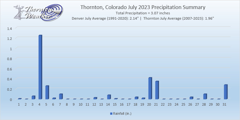
Denver’s weather is not often boring. Lightning, hail, tornadoes and even swarms of grasshoppers have made appearances this week in Denver weather history.

From the National Weather Service:

19-30

In 1875…grasshoppers appeared in great numbers at 10:00 am on the 19th. Thousands landed on the ground. The streets were literally covered with them. Swarms of grasshoppers were seen on each day. All gardens in the city were devastated…and in the countryside the grasshoppers were very destructive to ripened grain. On the 30th the grasshoppers were so numerous as to almost darken the sun.

20

In 1980…winds to 55 to 60 mph were recorded in south Boulder.

In 1982…strong thunderstorm winds blasted the Jefferson County Airport near Broomfield…causing an estimated 3 million dollars in damage. At least 5 hangars and 15 airplanes were damaged…many seriously; one hangar was completely destroyed. Torrential rains accompanied the winds. Heavy rains also dumped on Boulder where 1.65 inches fell in just 15 minutes…causing street flooding. Wind gusts to 72 mph were recorded in Boulder. Over half an inch of rain fell in just 5 minutes in Littleton where two homes were struck by lightning. Lightning also struck a house in Arvada where over an inch of rain sent Ralston Creek over its banks. Strong winds accompanied the storms.

In 1984…slow moving thunderstorms dumped 1.25 inches of rain in Evergreen…causing street flooding. A half inch of rain fell in just 18 minutes in southeast Denver. Littleton and Boulder were also drenched with about an inch of rain. Rainfall totaled 0.92 inch at Stapleton International Airport.

In 2001…severe thunderstorms produced damaging winds and large hail across metro Denver. Hail as large 1 inch in diameter fell in Aurora near Cherry Creek. Strong thunderstorm winds gusting as high as 58 mph blew the roof from a building between Thornton and Denver and toppled several trees in Denver. One tree landed on a mail truck. Other thunderstorm winds were clocked to 60 mph near Parker… 62 mph in Broomfield…and 61 mph at Denver International Airport.

In 2006…a tornado (f0) touched down near Bennett…but caused no reported damage.

In 2013…severe thunderstorms pounded the southern Denver suburbs and other parts of the Front Range. In Jefferson County…water rescues were reported for some people in stranded cars. In the Ken Caryl area…large hail from one inch to 1 3/4 inches in diameter was reported. On West Chatfield Avenue in Jefferson County…hail runoff gathered six inches deep in spots and “hail plows” were sent out to clear some streets. Hail up to one inch in diameter was also reported near Castle Rock.

21

In 1876…heavy thunderstorm rain and hail struck the city. Hail stones as large as partridge eggs accumulated to a depth of 1 1/2 feet over eastern portions of the city. The heavy rainfall flooded streets and gutters. However… No significant damage was reported. Rainfall totaled 0.85 inch in central Denver.

In 1903…a thunderstorm produced west winds sustained to 42 mph with gusts to 48 mph.

In 1957…heavy thunderstorm rainfall and hail over the bear creek basin flooded portions of State Highway 8 in and near Morrison. There was also minor property damage in Morrison.

In 1995…a 68-year-old woman was struck by lightning while standing near a tree in Brighton.

In 2006…a severe thunderstorm produced 7/8 inch diameter hail in Franktown.

In 2019…severe thunderstorms produced hail up to 1 inch in diameter in parts of Arapahoe…Denver and Jefferson counties. Heavy rain and flash flooding…close to 2 inches in one hour…also accompanied the nearly stationary storms. In Denver…flash flooding caused several vehicles to be stranded at Martin Luther King Blvd and Dahlia Street. Highway 6 near Federal Blvd also flooded. Standing water up to 3 feet deep occurred in Park Hill. Lastly…water made its way into buildings north of Interstate 70. At Denver International Airport…just a trace of rainfall was recorded.

22

In 1898…an apparent thunderstorm produced southwest sustained winds to 40 mph with gusts to 43 mph.

In 1903…a late afternoon thunderstorm produced rain…hail… And east winds sustained to 40 mph with gusts to 44 mph.

In 1904…the lowest recorded temperature in August…40 degrees…occurred. The same temperature also occurred on three consecutive days…August 24…25…and 26 in 1910.

In 1965…heavy rain and hail caused some damage from flooding over northern Douglas County from Castle Rock to Franktown.

In 1981…thunderstorms moved across metro Denver. At least 5 funnel cloud sightings were reported. Funnel clouds were seen at 96th Ave. and Sheridan Blvd. And at 92nd Ave. and Federal Blvd. in Westminster and 7 miles north of Stapleton International Airport. Lightning injured two people in Boulder. A quarter inch of rain fell in just 5 minutes in Brighton. Up to 3/4 inch of rain doused Parker in 30 minutes.

In 1983…3/4 inch diameter hail was reported at Kittredge… Along with 0.60 inch of rain in 25 minutes.

In 1984…a thunderstorm dumped 4 inches of rain on Brighton in 90 minutes…causing extensive street flooding in the downtown area.

In 1987…over an inch of rain fell in 24 hours throughout most of metro Denver. A public library suffered water damage to the ceiling…carpet…and a few books. Rainfall was 0.76 inch at Stapleton International Airport.

In 1990…lightning knocked out power to about 2500 homes in Lakewood for about an hour.

In 1991…National Weather Service personnel at Stapleton International Airport sighted an apparent tornado briefly on the ground 3 miles west-northwest of the airport. No damage was reported.

In 1995…lightning struck 3 electrical power substations in Louisville. Residences of more than 4500 people were without power from 30 minutes to more than an hour.

In 1996…between 1 and 3 inches of rain fell across metro Denver. As a result…several low lying areas were flooded. A bicyclist was swept into a fast moving creek when he tried to cross a flooded bike path. The man was washed downstream about 15 feet before getting snagged by a tree stump. He and a man who tried to rescue him received minor injuries. The heavy rain caused numerous power outages…false fire alarms…and traffic accidents. In Lakewood…telephone service to around 60 thousand residents was knocked out when a switching center was flooded. Funnel clouds were sighted near Chatfield Reservoir and Highlands Ranch.

In 2000…lightning sparked a blaze which gutted a 10-unit apartment building in Highlands Ranch. Twenty-eight people were left homeless. Damage was estimated at 2 million dollars.

In 2007…severe thunderstorms produced large hail…up to 1 1/4 inches in diameter…in the vicinities of Castle Rock… Elizabeth and Franktown.

In 2013…flash flooding occurred in central Douglas County with numerous road closures reported. One of the closures occurred at the Tomah Road exit along I-25…south of Castle Rock.  The closure backed up all I-25 the way to Castle Rock. At Denver International Airport…1.94 inches of precipitation was recorded…which set a new record rainfall for the date. The old record was 0.75 inches… set back in 1953.

22-24

In 1987…some locations in metro Denver had a total 3-day rainfall of 2 to 4 inches. Rainfall totaled 0.96 inch at Stapleton International Airport.

23

In 1900…northwest winds were sustained to 42 mph with gusts to 49 mph.

In 1921…a thunderstorm cloudburst produced 2.20 inches of rainfall in an hour over downtown Denver. This is the greatest 1 hour rainfall on record at the official observing site in the city. Precipitation totaled 2.93 inches…which is the greatest calendar day precipitation ever recorded in August.

In 1941…one man was killed by lightning about 2 miles from the official weather station in downtown Denver.

In 1962…a home near Boulder was destroyed by a lightning- caused fire.

In 1968…strong winds buffeted Boulder briefly during the early morning hours. At the National Center for Atmospheric Research…winds averaged 55 mph with gusts to 85 mph. Damage was minor. Northwest winds gusted to 31 mph at Stapleton International Airport.

In 1977…lightning damaged at least 6 homes in Aurora.

In 2008…a landspout touched down near Westcreek in Douglas County. One man was seriously injured when he tried to escaped several falling trees in his ATV. One of the trees struck his back and broke two vertebra. Another camper narrowly escaped injury. Seconds after he back up his truck…a tree came down where it had been parked.

In 2019…a severe thunderstorm produced large hail…up to 2 1/2 inches in diameter 5 miles west of Byers. Hail up to 1 3/4 inches in diameter was reported near Bennett.

24

In 1880…a thunderstorm produced vivid lightning and heavy rainfall…which caused flooding over the eastern part of the city including the brick yards. There was no rainfall recorded in downtown Denver.

In 1910…an apparent dry cold front caused a remarkable drop in temperature. From 3:00 pm until midnight the temperature fell from a high of 93 degrees to a low of 40 degrees. Northeast winds were sustained to 44 mph during the late afternoon.

In 1946…heavy rain near Idledale caused flooding on bear creek at Morrison…which resulted in one death when a woman was swept from her stranded car and drowned.

In 1973…strong winds blew down a few power lines and hail up to 3/4 inch diameter fell in southeast Aurora.

In 1984…heavy rain hit the south Denver area. Over an inch fell in less than an hour at both Castle Rock and Sedalia.

In 1992…heavy rains caused flash flooding across parts of metro Denver. Rainfall amounts of 1 to 3 inches fell with the hardest hit areas being the southwest and central parts of metro Denver. Bear Creek rose above bankfull near Idledale with flood waters moving into southwest metro Denver. Mud and rock slides along Colorado highway 74 west of Morrison were reported. The confluence of Cherry Creek and the South Platte River in downtown Denver also went out of its banks…flooding bike paths. Rainfall totaled 1.98 inches at Stapleton International Airport where light to moderate rain fell most of the day. Heavy rain and fog briefly reduced the surface visibility to 1 1/2 miles. The temperature climbed to a high of only 58 degrees…which was a record low maximum for the date.

In 2002…hail to 7/8 inch in diameter was measured in southwest Denver.

In 2008…several landspout tornadoes developed along a boundary to the southeast of the Denver metropolitan area during the Democratic National Convention. In northwest Elbert County… Minor damage was reported. The damage consisted of downed power lines…broken windows and an out building. Severe thunderstorms also produced very heavy rain and large hail… Up to one inch in diameter. In southwest Douglas County… Heavy rain caused flash flooding near the town of Westcreek. A mudslide closed State Highway 67. The road in the YMCA camp shady brook was also washed out and some bridges were damaged.

24-26

In 1910…the lowest temperature ever recorded in August…40 degrees…occurred on each of these days and on August 22… 1904. The unusually cold weather for so early in the season brought sub-freezing minimum temperatures to much of the Colorado northeastern plains.

25

In 1951…a microburst produced a southwest wind gust to 50 mph at Stapleton Airport. Only a trace of rain was observed.

In 1964…thunderstorm winds gusted to 59 mph and caused some blowing dust at Stapleton International Airport.

In 1994…lightning struck a power pole in Louisville and caused a two-hour power outage.

In 2008…an unoccupied home was struck by lightning in Aurora… Causing 75 thousand dollars in damage to the roof.

26

In 1944…one of the most destructive hailstorms in the city in a decade caused damage estimated at nearly one million dollars. The storm occurred within a period of 10 to 30 minutes…between 2:00 pm and 3:00 pm. The hail varied in size from very small to as large as 1 1/2 inches in diameter. Hail covered the ground to a depth of 5 to 6 inches in some sections of the city. Several people were cut by broken glass. The hail and heavy rain flooded underpasses to a depth of 6 feet…and the occupants of stalled autos had to be rescued. Sewers were unable to handle the sudden amount of water and water backed up and flooded a number of basements. A few first floors of buildings were flooded. The water department had a busy time replacing manhole covers that had been displaced by the water pressure. Trees were stripped…one was severely broken…and telephone lines were downed. Roofs…windows… Automobiles…awnings…and gardens were severely damaged. Flowers and gardens in some sections of the city were a total loss. Greenhouses were extensively broken with an estimated 20 carloads of glass shattered. Vegetable and truck crops in and around the city were severely shredded. The next day the American Red Cross was designated by the War Agency to grant any and all priorities needed to obtain materials and supplies to replace and repair the damage. In downtown Denver…the thunderstorm produced 0.95 inch of rain and heavy hail along with sustained northwest winds to 25 mph.

In 1961…strong winds blew in the walls of a warehouse under construction in Denver. Two workmen suffered a fractured foot and body bruises.

In 2014…two men in central Denver were struck by lightning as they sat under a tree to avoid a heavy downpour. One of the men was unconscious and had no pulse when emergency responders arrived. He was immediately taken to Denver Health was listed in critical condition. The other victim suffered less severe injuries. He was treated at the scene and hospitalized…then released a few hours later.

26-27

In 1980…two heavy thunderstorms hit Arvada and Westminster… Dumping up to 1.50 inches of rain in less than an hour. At least two streets were washed out and a number of homes and cars were damaged when a creek flooded. Three homes in Arvada sustained minor lightning damage.

Denver sets record high minimum for August 18

Record High Temperature

Mother Nature isn’t giving a lot of relief at night from the daytime heat and as a result Denver set a record.

As measured at Denver International Airport, the Mile High City’s low temperature for today was only 69 degrees. This is a good bit warmer than the previous record high minimum of 67 degrees set in 2020.

Thornton virtually matched that reading with a low of 66.5 degrees.

Denver sets record low temperature for August 14

Record Cold Temperatures

Is that a chill in the air? No, not really, but it was cool enough to tie a record.

As measured at Denver International Airport, the Mile High City’s official low temperature for the date was 49 degrees. This ties the previous record low for the date set in 1976.

Here in Thornton, we stayed warmer with a low of 54.6 degrees.

August 13 to August 19: This week in Denver weather history

This Week in Denver Weather History

Severe weather is a fact of life in Colorado during the summer months and while August is historically relatively calm, that isn’t always the case. In our look back at this week in Denver weather history we see the dangers of lightning, incidents of large hail and flooding rains and even a tornado.

From the National Weather Service:

8-13

In 1875…clouds of grasshoppers were seen flying through the air on the prevailing winds during each day.

12-13

In 1975…heavy rains caused flash flooding along the foothills from Denver north. Thunderstorm rainfall totaled 1.56 inches at Stapleton International Airport.

In 2004…a brief cool spell resulted in two daily temperature records. The low temperature of 49 degrees was a record minimum for the 12th…as was the low temperature of 48 degrees on the 13th.

13

In 1959…thunderstorm winds gusted to 53 mph at Stapleton Airport.

In 1983…thunderstorms dumped torrential rain in Northglenn… Thornton…and Broomfield. Northglenn was drenched with 1.72 inches in 30 minutes. Street flooding was widespread. Hail…as large as 3/4 inch in diameter…was reported 7 miles northeast of Boulder along with heavy rain which caused some street flooding.

In 2000…lightning sparked 3 small grass fires near Golden. The fires were quickly contained. Hail as large as 3/4 inch in diameter fell in Castle Rock..

In 2019…Hail up to 1 3/4 inches in diameter was observed 4 miles west of Frederick…with hail up to one inch in diameter near Dacono.

14

In 1960…a bolt of lightning struck a man in Henderson… Causing serious burns.

In 1962…the temperature climbed to a high of 100 degrees at Stapleton Airport.

In 1968…a young man on a golf course in Denver was injured when lightning struck a tree under which he was standing. Lightning caused minor damage to a house in Denver. Heavy thunderstorm rain caused local street flooding. One inch diameter hail fell at Jefferson County Airport near Broomfield.

In 1973…winds as high as 85 mph damaged 20 aircraft at the Arapahoe County airport…now centennial airport.

In 1977…three tornadoes were sighted in Bennett. A man suffered a broken leg when hit by a flying board. He was outside his camper home…which was destroyed. All windows were broken in a near-by farmhouse where some shingles were ripped off and a 2 car garage was knocked down. Several vehicles were damaged and a cat…some rabbits…and chickens were killed. A broken oar from a boat was driven into the side of a house. A mobile home was overturned. One old barn was destroyed. Half a dozen homes and several agricultural buildings were damaged just west of State Highway 79.

In 1978…high winds produced much blowing dust…causing many traffic accidents in the Denver-Boulder area. Winds gusts of 70 to 101 mph were recorded. Northwest winds gusted to 44 mph at Stapleton International Airport.

In 1980…lightning hit two power poles in Littleton…causing 400 dollars in damage. Rainfall of 1.23 inches in a short time caused minor flooding…which included damage to a ground floor apartment and partially submerging a few vehicles in water. Thunderstorm rainfall totaled 0.98 inch at Stapleton International Airport.

In 1983…2.10 inches of rain drenched Golden in an hour with similar amounts in Lakewood and Boulder. Over ten thousand dollars worth of plants were washed away at a nursery in Lakewood.

In 1997…twelve motorists were injured in a multi-car accident when strong microburst winds estimated to 50 mph blew blinding dust across I-70 near Bennett.

In 1998…lightning struck a hydro-electric plant in Nederland… Causing a power outage. Residents in the foothills west of Boulder…including Nederland…Ward…Eldora…Jamestown… And Gold Hill…were without power for about an hour.

In 2006…heavy thunderstorm rainfall near Deckers washed away some the banks along State Highway 67 between Deckers and Westcreek. Several driveways on both sides of the highway were also damaged.

15

In 1899…a thunderstorm produced southwest sustained winds to 43 mph with gusts to 46 mph.

In 1972…a pilot reported a funnel cloud briefly touching the ground in open fields…17 miles east-northeast of Stapleton International Airport.

In 1980…thunderstorm winds gusted to 55 mph in Boulder.

In 1982…brief heavy rain and winds estimated as high as 70 mph occurred in the conifer-Evergreen area. No damage was reported.

In 1990…lightning triggered a small attic fire in a house near Sedalia…20 miles south of Denver. A furious lightning storm caused widespread power outages across southern sections of metro Denver. One lightning bolt knocked out an electrical substation…causing a 90-minute blackout in southeast Denver affecting nearly 10 thousand homes and businesses.

In 2007…severe thunderstorms produced large hail…up to 2 inches in diameter…near larkspur. Extensive damage to vehicles in the area was reported.

In Parker…lightning struck a residence. The ensuing fire damaged the attic and top floor; causing $100000 in property damage.

In 2008…at least three homes were hit by lightning during the early morning hours in Arapahoe County. Lightning also struck two homes in Castle Rock…damaging the roofs. Continue reading August 13 to August 19: This week in Denver weather history

August 6 to August 12: This week in Denver weather history

This Week in Denver Weather History

As we get further into the month of August severe weather is less common. It can however still strike as we see in our look at this week in Denver weather history. Everything from torrential rains to massive hail and even a tornado have been reported.

From the National Weather Service:

6

In 1877…a severe rain…hail…and wind storm struck Denver. The storm produced a one minute sustained wind speed of 75 mph. Rainfall totaled 1.00 inch in 25 minutes. The hail storm damaged vegetable gardens in the city.

In 1954…an unconfirmed tornado was reported in Westminster. A funnel cloud was sighted in the area…but it was not certain if it had touched down. No damage was reported.

In 1980…the temperature reached 100 degrees…setting a new record high for the date.

In 1982…3/4 inch diameter hail was reported in north Denver. Heavy rain caused street flooding in central Denver where 4 to 5 feet of water inundated I-25…closing the freeway for a while. Rainfall across metro Denver ranged up to 2.35 inches in just over an hour. An estimated 2000 basements were flooded. Only 0.01 inch of rain fell at Stapleton International Airport.

In 1991…heavy rain caused flooding at the junction of I-25 and I-70. Dime size hail was reported northeast of Boulder near Niwot.

In 1995…microburst winds gusting as high as 58 mph caused minor damage to an apartment complex in Broomfield. Some homes under construction were also damaged when the winds knocked over 2 by 4 wood beams along with some insulation and roofing materials…which broke a few windows. Microburst winds also overturned a camper near Barr Lake.

In 1996…hail ranging in size from 1 to 1 1/2 inches fell near Bennett.

In 2001…3/4 inch hail fell in the foothills near Conifer.

In 2008…a record daily rainfall record was set at Denver International Airport. The record of 1.29 inches in 24 hours broke the previous record of 1.10 inches set in 1929.

In 2020…a severe thunderstorm developed near Byers. The wind snapped large tree branches…up to 4 inches in diameter…and produce large hail up to one inch in diameter. At Denver International Airport…a peak wind gust to 47 mph was observed from the west.

7

In 1948…a brief west moving tornado was sighted 3 miles north-northeast of Stapleton Airport. The white funnel silhouetted against a gray cloud background was very narrow…nearly vertical…and estimated at nearly 5 thousand feet high. A dust cloud formed on the ground around the funnel. No damage was reported.

In 1952…a thunderstorm wind gust to 52 mph was recorded at Stapleton Airport.

In 2014…severe thunderstorms produced large hail across western and southern parts of metro Denver. Near Centennial and Golden…hail up to quarter size was reported. Near Bennett…a peak thunderstorm wind gust to 65 mph was also reported. At Denver International Airport…a peak wind gust to 46 mph was recorded.

In 2018…a severe thunderstorm produced large hail around Denver and vicinity. Hail ranging in size from 1 to 1 3/4 inches fell near Firestone…Ft Lupton…Parker…and Smoky Hill. Continue reading August 6 to August 12: This week in Denver weather history

July 2023 weather recap: A warm, wet summer month

Thornton, Colorado’s July 2023 temperature summary. (ThorntonWeather.com)

After a couple of months of cool, damp weather, we were hoping to warm up and dry out. We did get warmer (perhaps more than we would have liked) but we also continued to see a good bit of precipitation.

The first nine days of the month trended largely toward cooler-than-normal temperatures but overall, it was relatively pleasant with only a couple of hot days. We did also see some good moisture although much fell on a single day (1.25 inches on the 4th).

The middle of the month saw things turn hotter and we recorded back-to-back 100-degree days on the 17th and 18th. Rain became less prevalent and was light.

For the final third of the month, we continued to be quite warm with only three of the final 11 days seeing temperatures at or below normal. Otherwise, the readings were a good bit above. Three days of the final 11 also delivered more than a quarter inch of rain each.

Thornton’s overall average temperature for July 2023 came in at 74.1 degrees. That is a bit above the running 17-year average for July of 73.7 degrees. Our warmest reading of 100.5 degrees came on the 25th while our coolest of 50.2 degrees came on the 1st.

In the Mile High City, at Denver International Airport where Denver’s official readings are now taken, the month was a bit cooler. They had an overall average for July of 73.9 degrees. Two 98-degree days were their warmest and their coolest was 52 degrees on the 21st.

In terms of precipitation, Thornton had quite a wet one with 3.07 inches falling in our rain bucket. That was well above the 1.96 inches 17-year average and made July 2023 the fourth wettest July of the past 17 years.

For Denver, DIA recorded 2.10 inches, right on par with the Mile High City’s July average of 2.14 inches and far below what Thornton received.

Click here to view Thornton’s complete July 2023 climate summary report.

Thornton, Colorado’s July 2023 precipitation summary. (ThorntonWeather.com)


Thornton’s August 2023 preview: Temperatures begin to cool, fewer storms intrude

As summer vacations wind down and families prepare to send their kids back to school in August, Colorado weather also starts to settle down. The chances for severe weather decrease markedly during August and by the end of the month daytime temperatures are dropping quite a bit as well.

Find out more about what lies ahead with Thornton’s August weather here.

July 2023 top shots: Monthly photo slideshow

July 21, 2023 - The setting sun lights up thunderstorms. (David Canfield)
July 21, 2023 – The setting sun lights up thunderstorms. (David Canfield)

Colorado offers outdoor opportunities unlike any other state and while the summer heat settles in, photos of the amazing scenes across our state provide a view into why we love it here so much.

The weather this time of year has a pretty standard pattern of quickly warming temperatures followed by afternoon thunderstorms that can cool things down.  These storms sometimes provide a good bit of ‘excitement’ and are a prime photo subject.

  • Slideshow updated July 31, 2023

Recreationalists head outdoors and take advantage of urban, suburban and rural opportunities.  As they do, our abundant wildlife that is found just about anywhere comes into focus.

Showcasing images captured by ThorntonWeather.com readers as well as some of our own, our monthly slideshow covers the entire gamut of weather and nature related imagery.   Sunsets, sunrises, wildlife and of course every type of weather condition are vividly depicted.

To learn more about how to send your photo to us for inclusion in the slideshow, see below the slideshow.

[flickr_set id=”72177720310013337″]

What is missing in the slideshow above?  Your photo!

Our monthly photo slideshow is going to feature images that we have taken but more importantly images that you have captured.  The photos can be of anything even remotely weather-related.

Landscapes, current conditions, wildlife, pets, kids.  Whimsical, newsy, artsy.  Taken at the zoo, some other area attraction, a local park, a national park or your backyard.  You name it, we want to see and share it!

Images can be taken in Thornton, Denver or anywhere across the extraordinary Centennial State.  We’ll even take some from out of state if we can tie it to Colorado somehow.

We’ll keep the criteria very open to interpretation with just about any image eligible to be shown in our slideshows.

What do you win for having your image in our slideshow?  We are just a ‘mom and pop’ outfit and make no money from our site so we really don’t have the means to provide prizes.  However you will have our undying gratitude and the satisfaction that your images are shared on the most popular website in Thornton.

To share you images with us and get them included in the slideshow just email them to us or share them with ThorntonWeather.com on any of the various social media outlets.  Links are provided below.

So come on, get those camera’s rolling!

July 30 to August 5: This week in Denver weather history

This Week in Denver Weather History

How does 42 degrees sound right about now? That mark is one of the highlights of this week in Denver weather history. It was the low temperature recorded twice in our past and the coldest July temperature on record. Many more notable events have also occurred.

From the National Weather Service:

13-5

In 2008…a streak of 24 consecutive days of 90 degrees shattered the previous record of 18 consecutive days established in 1901 and 1874. Ironically…no new single day record high temperatures were set in the month of July. In August however…a record of 104 degrees was set on the 1st…and another record of 103 degrees was set on the 2nd. In addition…a record low min of 70 degrees was set on August 2nd.

18-2

In 1987…a streak of 16 consecutive days of 90 degrees ranked 4th on the list of hot streaks. The record of 24 consecutive days was established in the summer of 2008.

27-31

In 1956…96 percent of the total precipitation for the month of July occurred over the last five days of the month. Heavy thunderstorms produced 4.00 inches of rainfall at Stapleton Airport. This amount of precipitation in 5 days or less had been exceeded only 3 times in previous record. The last time had been in December of 1913 as snow. Considerable property damage occurred across metro Denver from flooding.

28-30

In 1889…dense smoke from forest fires in the mountains obscured the sun over the city for three days.

In 1971…a vigorous cold front late on the 28th produced northeast wind gusts to 39 mph and record breaking cold temperatures on the 29th and 30th. The temperature dipped to 47 degrees on the 29th and 43 degrees on the 30th… Setting record minimums for the dates. Upslope cloudiness along with rain and fog early on the 29th helped set a record low maximum temperature of 58 degrees for the date.

29-30

In 1997…heavy rain caused flooding and flash flooding in central portions of Adams and Arapahoe counties. Two homes were extensively damaged when water flooded the basements and adjacent pasture area in Strasburg. Water 4 to 5 feet deep had pooled in the lower lying areas of the town. A portion of Quincy Road was closed in Arapahoe County when 4 feet of water covered the roadway. Rainfall totaled 3.06 inches at Denver International Airport…establishing a new record for 24-hour rainfall in July. The previous record was 2.42 inches set in 1965 on the 24th and 25th.

30

In 1879…lightning struck a brick kiln in north Denver. Three men were knocked senseless…but all recovered. Rainfall in the city was only 0.09 inch.

In 1881…a thunderstorm dumped heavy rain and hail on the city…causing street flooding and much damage. A heavy torrent of rain fell with 1.10 inches measured in just 20 minutes. Storm total rainfall was 1.60 inches. The rain turned streets into running streams. Wood street crossings were torn up and washed away. The storm caused great damage by flooding many cellars where goods were stored. The brick yards suffered severe damage when the heavy rainfall destroyed many unfired bricks.

In 1913…northeast winds were sustained to 41 mph with gusts to 48 mph.

In 1939…a thunderstorm produced 0.08 inch of rainfall. This was the only measurable precipitation of the month…making the month the second driest July on record.

In 1961…heavy rain and lightning disrupted power lines and caused flooding in Denver. Thunderstorm rains totaled 1.60 inches at 11th and Lincoln in central Denver.

In 1972…the temperature climbed to a high of 100 degrees at Stapleton International Airport.

In 1983…hail 3/4 to 1 inch in diameter fell in central and southeast Denver and in Littleton. Rainfall of 1.50 inches occurred in just 30 minutes in Littleton. There was some street flooding in both cities with wind gusts up to 55 mph.

In 1984…central Aurora was hit by a downpour that produced 1.80 inches of rain and sent water 2 to 3 feet deep into some streets. Before the rain stopped later in the evening… The storm had dropped as much as 2.80 inches of moisture on the city. Thunderstorm rainfall totaled only 0.82 inch at Stapleton International Airport.

In 1985…a tornado was spotted in open country 10 miles southwest of Bennett. No damage was reported. One inch hail was reported in south Lakewood.

In 1997…one man was killed and his girlfriend critically injured when they were struck by lightning on the Kennedy Golf Course in southeast Denver. Both were struck in the head when they took refuge under a tree during a downpour. Lightning struck a home in unincorporated Arapahoe County east of Buckley Field. The fire started in the electrical panel boxes…causing extensive damage to the home. Heavy rain and hail triggered a flash flood in Boulder…which sent water through a window of the financial aid office on the University of Colorado campus. In addition…ceiling tiles…carpets…and dressing rooms were damaged at the Coors Events Center when a pipe draining rainwater broke during the downpour. In all…10 buildings on the campus received water damage estimated at 100 thousand dollars. Hail as large as 1.25 inches in diameter accompanied the heavy rain in Boulder. Thunderstorm rainfall totaled 2.71 inches at Denver International Airport where west winds gusted to 41 mph. This was the greatest calendar day official precipitation ever recorded in July.

In 1998…heavy rain…up to 3 inches in an hour…caused flash flooding problems from Castle Rock to Parker. I-25 north of Castle Rock was closed as high waters covered sections of the highway. Some cars were left floating in the flood waters.

In 2001…a severe thunderstorm produced a wind gust to 70 mph at a wind sensor on the northeast corner of Denver International Airport.

In 2004…a severe thunderstorm produced wind gusts to 71 mph in Evergreen.

In 2005…the temperature climbed to a high of 101 degrees at Denver International Airport. This was a new record maximum temperature for the date. In addition…this was the 7th day of the month with a high temperature of 100 degrees or more…which set a new Denver record for the most 100 degree days in a month…for a season…and in a year.

In 2019…a severe thunderstorm produced a peak wind gust to 58 mph from the north at Denver International Airport.

In 2021…a thunderstorm produced heavy rainfall…anywhere from 3.5 to 4.5 inches…produced flash flooding in Erie. Standing water stranded vehicles at the Intersection of Highway 7 and Mountain View Blvd. The fire department had to rescue a few motorists from their vehicles. A couple of basements also flooded.

31

In 1873…the all-time lowest recorded temperature in July… 42 degrees…occurred. The same temperature also occurred on July 4…1903.

In 1874…during the late afternoon rain and hail fell for 5 minutes followed by brief heavy rain. Pieces of solid ice of irregular shape fell upon the roof of the station. The hail stones measured 1 1/2 inches in diameter. Precipitation (rain and melted hail) was only 0.16 inch.

In 1889…the high temperature climbed to 100 degrees in downtown Denver.

In 1919…heavy thunderstorm rainfall totaled 2.59 inches in downtown Denver during the evening. Rainfall was 1.90 inches in an hour…a new record at that time.

In 1961…over an inch of rain in a short period of time caused flooding of streets and basements in Denver. Rainfall totaled 1.30 inches at 11th and Lincoln in central Denver.

In 1964…the temperature reached 91 degrees in Denver…making this the 27th day of the month that the temperature reached 90 degrees or more. This is the all time record for 90 degree days in a month in Denver.

In 1972…one inch diameter hail fell in Hudson northeast of Denver.

In 1976…during the evening hours extremely heavy thunderstorm rains produced flash flooding in Big Thompson Canyon which killed 144 people between Estes Park and Loveland. No significant weather occurred in metro Denver at the time.

In 1987…1 inch diameter hail fell in Lakewood and 3/4 inch hail fell near Louisville. Southeast Boulder County was drenched with 1.25 inches of rain in just 20 minutes.

In 1993…thunderstorm winds damaged a chimney of a home near Parker.

In 1996…a weak tornado (f0) was sighted 12 miles east of Denver International Airport. No damage was reported.

In 1998…heavy monsoonal thunderstorm rain triggered a mud slide in Blackhawk. The mudslide blocked Main St. and caused an estimated half million dollars in damage to a casino. Heavy thunderstorm rain…up to 3 inches in an hour…caused a flash flood along Buffalo Creek. Portions of County Road 126 just south of the town of Buffalo Creek were washed out. The flood waters nearly washed away the bridge as mud and debris slammed into the structure. Hail to 1 3/4 inches in diameter fell near Idaho Springs.

In 2004…severe thunderstorm winds toppled a 65-foot blue spruce tree in Parker. The tree landed on a home damaging the roof and gutters. The downed tree poked dozens of holes into the shingles.

In 2013…severe thunderstorm winds… with gusts estimated to 80 mph…downed power poles which caused scattered outages in and around Byers…Bennett and Strasburg. Some property damage was also observed. Near Byers…aluminum siding and roofing was peeled off sheds. Large hail…up to one inch in diameter… was reported north of Bennett. At Denver International Airport…a peak wind gust to 40 mph was observed from the northeast.

1

In 1888…heavy rain in the mountains and foothills caused flooding on clear creek in Golden. The high waters also washed away portions of the railroad tracks in the canyon between Idaho Springs and Golden.

In 1901…the temperature reached a high of 100 degrees in the city.

In 1902…the high temperature climbed to 100 degrees in downtown Denver.

In 1914…a thunderstorm produced 1.00 inch of rainfall in just 21 minutes and north winds sustained at 43 mph with gusts to 50 mph. Rainfall totaled 1.17 inches.

In 1938…the temperature climbed to a high of 100 degrees in downtown Denver…which is the record maximum for the date. The temperature was also recorded on this date in previous years.

In 1976…flight operations at Stapleton International Airport were suspended for 90 minutes when the airport tower radar was knocked out and water reached a foot deep on some taxi ramps after 1.50 inches of rain fell in one hour. Heavy rain also caused minor flooding in east Denver and Aurora where lightning damaged the roof of a home and injured the owner. One young man was swept down a flooded ditch…but was rescued by firemen. A number of rafts were floated in flooded streets. Thunderstorm rainfall totaled 1.71 inches at Stapleton International Airport.

In 1978…a tornado damaged a house and broke a power pole 5 miles northwest of Parker. A microburst wind gust to 52 mph briefly reduced visibility to 1 mile in blowing dust at Stapleton International Airport.

In 1985…heavy thunderstorms roared through the southern and western sections of metro Denver…producing large hail and heavy rain. Lightning hit a recreational vehicle trailer causing it to burn. There was a lot of street flooding over western suburbs where rainfall totaled over 2 inches in some areas. One inch diameter hail was reported in Littleton and near Evergreen. Hail piled 4 to 6 inches deep at Tinytown in the foothills southwest of Denver.

In 1990…a small rope-like tornado was spotted in open country 15 miles southeast of centennial airport. No damage was reported from the twister.

In 1992…pilots reported a funnel cloud near the construction site of the new Denver International Airport. A few minutes later…a tornado was reported near Bennett. The tornado remained on the ground for about 18 minutes and was visible from the national weather service office at Stapleton International Airport. Thunderstorm wind gusts to 70 mph were reported near Bennett and Watkins with a wind gust to 60 mph at Brighton. Two men were injured when struck by lightning. A young man sustained serious injuries when struck by lightning while jet skiing on Cheery Creek Reservoir. A man received only minor injuries when struck by lightning while golfing in Westminster.

In 1994…heavy thunderstorm rains in the foothills west of Denver caused the closure of the Virginia Canyon Road north of Idaho Springs by rocks and debris.

In 2001…a 34 year old man on the South Platte River bike path in Denver received minor injuries when lightning struck a nearby tree. Lightning…coupled with strong thunderstorm winds…knocked out electrical power to about 10 thousand homes and businesses in Golden.

In 2006…strong thunderstorms hit southern metro Denver. A severe thunderstorm wind gust estimated to 71 mph knocked down a tree in Aurora near Cherry Creek. Lightning sparked a fire in a home near lone tree and struck a transformer at an RTD light rail station at Interstate 25 and Yosemite Street. Heavy thunderstorm rainfall forced the closure of Arapahoe Road between Holly and Quebec streets due to high water. Flooding was also reported near Park Meadows Mall and Greenwood Village. Heavy rainfall also caused flooding in Highlands Ranch…lone tree…and Parker. Water up to 6 inches deep was reportedly running over the roads.

1 – 31

In 2020…a worsening drought that started in the spring of 2020…continued through August. The month of August tied with 2011 for the warmest August on record. It also occurred in the middle of the second warmest summer on record. The combination of hot and dry conditions…in addition to critically dry fuels from years of beetle kill…resulted massive wildfires. The Cameron Peak fire…which became the largest wildfire in the state`s history started on August 13th and continued to burn into October. Smoke from this wildfire in addition to several other large wildfires in Colorado and the West resulted in multiple days of extremely poor air quality. In addition…the air quality in Denver and the entire Front Range had deteriorated severely due to the very warm temperatures and high ozone content… which had spiked significantly. In August…26 days in the month equaled or exceeded 90 degrees. Continue reading July 30 to August 5: This week in Denver weather history

July 23 to July 29: This week in Denver weather history

This Week in Denver Weather History

As we near the end of July the weather in Denver tends to be a bit more stable. That doesn’t mean the severe weather threat disappears as can be seen at our look back at this week in Denver weather history. Particularly notable are lightning injuries and deaths, flash flood events and even tornadoes.

From the National Weather Service:

7-25

In 1934…a streak of 15 consecutive days of 90 degrees ranked 5th on the list of hot streaks. The record of 24 consecutive days was established in the summer of 2008.

13-5

In 2008…a streak of 24 consecutive days of 90 degrees shattered the previous record of 18 consecutive days established in 1901 and 1874. Ironically…no new single day record high temperatures were set in the month of July. In August however…a record of 104 degrees was set on the 1st…and another record of 103 degrees was set on the 2nd. In addition…a record low min of 70 degrees was set on August 2nd.

18-2

In 1987…a streak of 16 consecutive days of 90 degrees ranked 4th on the list of hot streaks. The record of 24 consecutive days was established in the summer of 2008.

19-23

In 2005…the high temperature climbed above 100 degrees on each of the 5 days with readings of 101 on the 19th…105 on the 20th…104 on the 21st…and 102 on both the 22nd and 23rd. A new record maximum temperature for the month of July of 105 degrees was set on the 20th…which also equaled the all time record maximum for Denver of 105 degrees first set on August 8th in 1878. Daily maximum temperature records were set on each day…and the 5 day period equaled the record for the most consecutive days of 100 degrees or more first set from July 4th through 8th in 1989. The intense heat resulted in a high use of electricity for cooling purposes. The demand for electric power exceeded the supply and rolling black-outs… Each lasting about an hour…were scheduled across metro Denver during the afternoons and early evenings.

20-23

In 1961…unusually cool weather for July resulted in several temperature records. Record minimum temperatures were set or equaled on each day with readings of 51…51…49… And 49 degrees. High temperature of only 64 degrees on the 21st was a record low maximum for the date.

20-25

In 1965…heavy showers and thunderstorms doused metro Denver with significant rain each day. Rainfall for the six days totaled 5.16 inches at Stapleton International Airport. Massive rainfall occurred on the 20th…21st…and 25th… Flooding streets and basements and causing streams to overflow. The heaviest rainfall…2.05 inches…at Stapleton International Airport occurred on the 25th.

22-23

In 1991…heavy rains over the palmer divide and along the Front Range caused the South Platte River to flood from near Henderson to Fort Lupton. The river was out of its banks at several locations with water covering the roads through the night. Only minor damage was reported.

24

In 1896…heavy cloudbursts in the foothills west of Denver caused flash flooding on Bear Creek…Clear Creek…Golden Gate Gulch…and Mount Vernon Creek…resulting in a total of 27 deaths. The downpour dislodged large Boulders…one of which crushed a house. The heavy rain also caused a dam on cub creek to wash out…adding even more water to the flood. A wall of water as high as 10 feet flooded Evergreen and passed down bear creek…washing away many structures along the way. The flood crest produced 3 feet of water in downtown Morrison during the early evening. Flash flooding on Mount Vernon Creek added to the flooding in Morrison. In Golden…the flooding washed out bridges on clear creek and on Cresman and Tucker gulches and forced the closure of the power plant. In Denver…a thunderstorm produced hail of unknown size during the afternoon and rainfall of 1.23 inches overnight.

In 1958…a thunderstorm wind gust to 52 mph was recorded at Stapleton Airport.

In 1965…heavy rain caused flooding on clear creek and tucker gulch in Golden and west Denver. Damage in Golden was estimated at 80 thousand dollars. Heavy rain south of Denver washed out temporary earthen bridges constructed following the June floods in Castle Rock…Littleton… Englewood…and Denver. Bear creek in south Denver reached flood stage. A cloudburst on cub creek in Evergreen washed out bridges and roads. Heavy rain fell over all the Denver and Aurora areas…causing some flooding of roads…streets… And bridges. A man drowned in a flooded irrigation canal near Hudson. Heavy rain caused flooding of streets and roads in Blackhawk and central city. Hail caused minor damage in Idaho Springs.

In 1967…seven bridges were washed out along a normally dry creek bed south of State Highway 7 west of Brighton. One car was washed into the creek when a bridge gave way.

In 1970…hail stones to 1 1/4 inches in diameter fell in the foothills of Jefferson County southwest of Denver.

In 1971…golf ball size hail was reported in foothill areas of Jefferson County west of Denver. A funnel cloud was sighted in Aurora. Wind gusts estimated at 60 mph…hail… And heavy rain up to an inch in 15 minutes caused local flooding and some other damage in several areas of metro Denver. Hailstones to 3/4 inch in diameter fell 7 miles southeast of Denver.

In 1973…a thunderstorm wind gust to 52 mph was recorded at Stapleton International Airport where one inch diameter hail was measured.

In 1981…strong winds downed a power line in northeast Denver. Wind gusts to 50 mph were recorded at Chatfield Reservoir.

In 1987…3/4 inch diameter hail fell 5 miles northeast of Commerce City.

In 1996…hail…up to 1 3/4 inches in diameter…fell at Chatfield Reservoir. Hail to 3/4 inch in diameter was measured near Bennett.

In 2000…lightning struck near two golfers at ute creek golf course near Longmont…knocking them to the ground. The men received only minor injuries.

In 2001…lightning from a thunderstorm knocked out electrical power to about 1500 residents in the city of Denver.

In 2004…a chilly day with fog and thunderstorms resulted in two temperature records. The low temperature of 49 degrees was a record minimum for the date. The high temperature of only 58 degrees was a record low maximum for the date.

In 2016…severe thunderstorms produced damaging straight-line. A storm leveled a greenhouse and caused tree damage near Byers. A peak wind gust to 74 mph was measured at Denver International Airport.

In 2018…thunderstorms produced very heavy rainfall…1 to 2 inches in less than 30 minutes. In Englewood…the floodwaters quickly inundated a basement apartment and trapped a woman inside. She was found unresponsive in the apartment and died several hours later. Several homes in the immediate area suffered severe flood damage. The floodwaters also stalled vehicles and forced the closure of several intersections. In Sheridan…the heavy rain created a large sinkhole which swallowed a small SUV. A downed power line caused a fire in Arapahoe County.

24-25

In 2003…maximum temperature of 100 degrees on the 24th was a record high for the date. Low temperature of 73 degrees on the 25th was a record high minimum for the date.

25

In 1875…brief heavy rain and hail lasted only 5 minutes… But the 1/4 inch diameter hail covered the ground to a depth of 1/2 inch and made the streets look like there had been snowfall. There was much crop damage…especially to corn…and some sheep were killed. Precipitation totaled 0.51 inch in the city.

In 1896…a heavy thunderstorm produced sustained northwest winds to 45 mph with gusts to 50 mph and 1.02 inches of rain.

In 1965…a cloudburst dumped 1.99 inches of rain in 30 minutes at Stapleton International Airport. The storm was accompanied by strong winds gusting to 70 mph. The heavy rain flooded numerous streets in east Denver and Aurora. One inch diameter hail accompanied a cloudburst…9 miles southwest of Denver. A funnel cloud was sighted 25 miles northwest of Denver. In Aurora…there were unofficial reports of 2.30 inches of rain in 40 minutes and 3.30 inches of rain in 30 to 40 minutes. Rainfall totaled 2.05 inches at Stapleton International Airport. Rainfall of 2.42 inches for 24 hours on the 24th and 25th was the second greatest on record for July.

In 1977…a tornado touched down briefly in Aurora southeast of Cheery Creek Reservoir. No damage was reported. A funnel cloud was sighted for 4 minutes by national weather service personnel 10 miles north of Stapleton International Airport near Henderson.

In 1991…heavy rain…up to half an inch in 10 minutes…caused flooding in Westminster…Northglenn…and north Denver where a section of railroad track was washed away. At Stapleton International Airport…heavy thunderstorm rain totaled 1.85 inches and briefly reduced the visibility to 1/4 mile. Hail to 1/8 inch in diameter was also measured. A tornado touched down briefly near Fort Lupton. No damage was reported.

In 1998…heavy monsoonal thunderstorm rains caused flooding and flash flooding in eastern and southern sections of metro Denver…including Englewood and Aurora…when about 2 to 3 inches of rain inundated the area. Both I-25 and I-70 were closed for 2 to 3 hours as several low lying areas became impassable due to the high waters. The water was estimated to be 15 feet deep in one flooded underpass along I-25. As a result…the freeway was closed from south of 6th Avenue to University Blvd. Standing water forced the closure of I-70 at gun club road east of Denver. In Englewood…U.S. Highway 285 was closed…when high water made it impassable. Several cars were reportedly floating down the roadway near Sheridan Blvd. In Aurora…the intersection at Yale Ave. And chambers rd. Was flooded by high water up to 4 feet deep when a spillway on the high line canal was breached. Lightning also knocked out 11 transformers across metro Denver…causing several small fires and scattered power outages. Flood and flash flooding also occurred north of Strasburg when as much as 2.51 inches of rain fell in an hour. The deluge resulted in considerable flooding of local streets and County roads. Torrential rainfall of 2 to 3 inches in less than an hour triggered a flash flood in Virginia Canyon. County road 279 between Idaho Springs and Central City was closed for two days to clear debris from mudslides. Several cars in Idaho Springs were washed off the road…and numerous basements were flooded in town. Thunderstorm rainfall totaled 2.69 inches at Denver International Airport.

In 2001…lightning struck two homes in Lafayette…damaging the roof and attic of one and shorting out the electrical system in another. Hail to 1 3/4 inch in diameter was measured 7 miles north of Castle Rock with 3/4 inch hail 7 miles north of Sedalia.

In 2005…heavy thunderstorm rain in the vicinity of the overland wildfire burn scar triggered a mudslide in Jamestown. Rocks the size of bowling balls…along with silt and mud slid down the mountain into the town. No one was injured. One parked car was buried by the debris.

In 2006…heavy thunderstorm rainfall caused flash flooding 1 mile north of the town of Westcreek in southwestern Douglas County. Several maintenance roads were washed out by the floodwaters.

26

In 1891…a thunderstorm produced sustained northeast winds to 44 mph with gusts to 60 mph and 0.16 inch of rain.

In 1894…a thunderstorm produced sustained southwest winds to 36 mph with gusts to 58 mph…but only 0.04 inch of rain.

In 1910…the high temperature reached 100 degrees in downtown Denver.

In 1959…a Denver man was stunned while standing by a car that was struck by lightning. He was treated for burns and shock at a local hospital. Thunderstorm winds gusted to 55 mph at Stapleton Airport.

In 1983…two heavy thunderstorms hit the northern and western suburbs. The first drenched Northglenn with an inch of rain in 30 minutes. The second storm dumped an inch or more of rain in Idaho Springs and Evergreen. The heaviest rainfall… 2.90 inches in an hour…caused minor street flooding in Golden.

In 1984…heavy early morning thunderstorms drenched the foothills southwest of Denver. Rainfall to 1 1/2 inches in just 30 minutes occurred between Evergreen and Conifer. In nearby Turkey Creek Canyon…1.80 inches of rain was recorded in 35 minutes.

In 1985…a long rope-like white tornado touched down 5 miles east of Erie and stayed on the ground…mainly over an open field…for 18 minutes. However…the twister damaged a few cars on I-25 and injured 3 people from broken glass. The storm flipped over a van…blew out car windows…and ripped a highway sign. It also blew an outbuilding off its foundation. A tornado also touched down briefly 8 miles north of Bennett. No damage was reported from this storm.

In 1988…a 9-year-old girl was slightly injured by lightning in Parker.

In 2003…a severe thunderstorm in and south of Franktown produced hail as large as 1.75 inches in diameter. Continue reading July 23 to July 29: This week in Denver weather history

Weather, natural disasters & climate news and information.