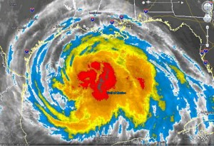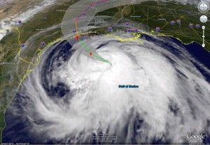
Potentially the most devastating hurricane since Hurricane Katrina three years ago is nearing the Texas Gulf Coast Friday morning. Hurricane Ike is currently 265 miles southeast of Galveston, Texas and expected to make landfall very near that coastal island city around midnight tonight. Ike is so large though that the outer bands of the storm are already starting to be felt along the coast and conditions will deteriorate there throughout today long before the eye makes landfall. Minor flooding along the barrier islands south of Galveston have been reported this morning as well.
Hurricane hunter aircraft have measured winds in Hurricane Ike at 105 mph making it a category 2 storm at the current time. The sheer size of the storm can be seen in the wind measurements which show hurricane force winds extend outward up to 120 miles from the center and tropical storm force winds extend outward up to 275 miles. As the storm nears the coast, it is expected to continue to strengthen and make landfall with category 3 winds of 115 mph.
Make no mistake – this is going to be a major storm. The National Weather Service office in Houston / Galveston has issued a very dire warning: “All neighborhoods … and possibly entire coastal communities … will be inundated during the period of peak storm tide. Persons not heeding evacuation orders in single-family one- or two-story homes will face certain death.”

The last time the National Weather Service used such strong language was with Hurricane Katrina and this simply serves to highlight the danger this storm presents. As always, the greatest danger with hurricanes is not the wind but the rain and storm surge that accompany it and Hurricane Ike has both of those in spades. Coastal storm surge up to 20 feet and large, dangerous battering waves are expected. 5 to 10 inches of rain are expected in eastern Texas, possibly up to 15 inches in some areas.
Over 400 miles of Texas coastline is under a hurricane warning now with nearly 1 million residents under evacuation orders. Galveston Island, population 280,000 is expected to take a near direct hit and is being evacuated. Mandatory evacuations remain in effect for low-lying coastal areas northeast and southwest of Galveston, in Chambers, Matagorda and Brazoria counties including parts of Houston.
National Weather Service meteorologist Kent Prochazka said, “Don’t stay… This is not a storm that people who have lived down here have probably experienced unless they’ve been here for more than … 70 or 80 years.”
For the latest on the storm’s location, please visit the ThorntonWeather.com Hurricane Tracker.
