Category Archives: Severe Weather

Stormchasers capture photo and video of stunning supercell in Wyoming

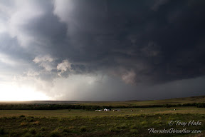
Spring brings severe weather to the Great Plains and with those storms comes stormchasers.  One group of chasers captured video and photos of a supercell’s amazing structure as it moved across northeastern Wyoming.

The video, taken by Basehunters, shows the motion of the swirling mass of a low precipitation supercell near Newcastle.  Still imagery provides a dramatic view of the storm cell.

Check them out below.


Live updates: Thornton’s September 2013 heavy rain and flood event

ThorntonWeather.com on Facebook, Google+ and TwitterThe start of meteorological fall has been highly eventful with record-setting high temperatures followed by virtually unprecedented rainfall.  Four days of steady, sometimes heavy, rain has created hazardous conditions in many places along the Colorado Front Range including Thornton.
We will be monitoring monitoring the storm very closely and posting regularly to our Facebook page and Twitter feed.  You can follow along in real time below.  We are also on Google+ here.

For comprehensive look at the storm, please monitor our Winter Weather Briefing page.


Unusual late September severe weather visits Colorado bringing tornadoes & hail

Severe weather more typical of June than late September hit Colorado yesterday.

September weather in Colorado is typically tranquil and one of the more pleasant months in the state.  This week however that wasn’t the case, especially yesterday when severe thunderstorms rumbled across the parts of the state.

Tuesday and Wednesday brought heavy rains to parts of the northern Front Range.  The precipitation was welcomed as it provided much-needed relief from the recently dry conditions.

Yesterday in Colorado Springs and La Junta thunderstorms brought hail that accumulated up to 6 inches deep.  Mother Nature however held more surprises as she brought tornadoes to other parts of the state.

Three tornadoes were reported in northeastern Colorado – one each in Adams, Douglas, and Weld counties.  None of the three caused any damage.

A fourth twister however occurred in southern Colorado near Del Norte in Rio Grande County northwest of Alamosa.  Local resident Julie Sauvigne captured amazing video of the tornado as it ripped through her property causing EF0 level damage to her home.

Watch the video below.  Notice how the visible funnel is almost directly above Sauvigne while the circulation on the ground was occurring in a field nearly a mile away!

Second day of storms miss Thornton so ThorntonWeather.com goes on the chase

A massive storm churns near Simla, Colorado on Thursday, July 7, 2012. See more photos in the slideshow below.

Mother Nature brought severe weather to northeastern Colorado again yesterday but for the second day in a row Thornton missed out on the action.  Since the storms wouldn’t come to us, ThorntonWeather.com went to the storms.

Thornton seems to be in a bit of a ‘storm drought’ of late with most thunderstorms passing us by and yielding little more than a few rain drops.  Elsewhere along the Colorado Front Range the story has been much different over the last two days.

The setup was near perfect thanks to the formation of a Denver cyclone with moist air pulling in from the south meeting dry air from the north.

ThorntonWeather.com took off in mid-afternoon and headed east to Bennett, then on to Byers and east on Highway 36.  The initial storm cell that was beginning to take shape broke in to three and decisions had to be made on which one to follow.

The southernmost cell seemed to hold the most promise so we headed south, through Limon and tracked the storm near Simla.

The storm would drop tennis ball size hail and push out wind gusts measured at 80mph.  As many as four tornadoes were reported to have been caused by the storm, a number which will be confirmed and finalized later today.

In Elbert County, emergency agencies are conducting damage assessments from at least one of the twisters that tore through the central part of the county.  Extensive damage to as many as seven homes west of Simla was seen.  One person received minor injuries.

Thursday’s storms were the second day in a row for severe weather in the area.  On Wednesday thunderstorms brought massive amounts of hail to the southern Denver metro area and Colorado Springs.  Tornadoes were also spawned although there was no damage from the twisters.

  • Stay up to date with Thornton’s weather: ‘Like’ us on Facebook, follow us on Twitter and add us to your Google+ circles

Weather Channel’s Mike Bettes takes risk-taking storm chasers to task

A storm chasers flipped vehicle is seen on the side of an Oklahoma road last week. (YouTube / TornadoVideosdotnet)

Getting the latest and most dramatic storm footage has become a popular way for many storm chasers to fuel their hobby and many have turned it into a lucrative business.  The actions by some in the chaser community and the risks they take have once again come under scrutiny, this time by the Weather Channel’s Mike Bettes.

Andy Gabrielson, a prolific storm chaser, was involved in a rollover accident last week while chasing a tornado in Oklahoma.  Video of the crash was captured by his own dash cam and video cameras of other chasers who assisted him afterwards.

Mike Bettes opined in an ‘Open Mike’ segment last week, “The one thing I always hear from professional chasers is how safety is their number one concern and warning the public is their number one priority.  Me?  I can B.S. on that one. When you’re getting hit by debris and you’re flipping your car while pursuing a tornado, you’re not very concerned about your safety or anyone else’s.”

As storm chasing has become a more popular hobby, fears are rising that it is only a matter of time before someone gets killed in pursuit of a storm.

The Natural Disasters Examiner wrote an analysis of the debate and has the video of Gabrielson’s crash.  Head over there to check it out.

Severe storms provide a bit of excitement, amazing views just east of Thornton

The bottom of a growing supercell thunderstorm near Denver International Airport. (ThorntonWeather.com)
The bottom of a growing supercell thunderstorm near Denver International Airport. (ThorntonWeather.com) View a slideshow of other images from the day below.

Yesterday’s forecast warned of the chance for severe storms and while Thornton escaped with just a few light rain showers, further to the east it was much more exciting.  As storms rolled off the foothills ThorntonWeather.com followed them east of DIA.

Many of the storms that formed yesterday were cut-off by mid-level winds that kept them from reaching their full potential.  One storm cell however reached full maturation eventually towering to an altitude of more than 25,000 feet.

The storm grew as it entered south-central Adams County south of Denver International Airport.  As it moved to the east side it exploded in height and soon had a classic anvil with an overshooting top.

While the storm was high-based and did not generate a tornado, it did eventually drop large hail in north-central Adams and southern Morgan counties.

Being the only real action in the area the storm drew a great deal of attention from area storm chasers, including ThorntonWeather.com.  At least a couple dozen chasers surrounded and followed the storm.  Below are some of the photos we took.

Be sure to follow us on Twitter and ‘like’ us on Facebook for all the latest weather news!

Severe weather pays a visit to Thornton; Time lapse video captures hail

The Thornton Multipurpose Fields are covered with water from rain and hail after severe weather moved through Thornton. (City of Thornton)

It was quite an eventful afternoon in the Denver metro area as thunderstorms spawned funnel clouds and massive amounts of hail.  ThorntonWeather.com’s webcams captured part of the action as the hail piled up enough to make it look like snow.

Our east webcam started to show some light precipitation before 1:00pm and before 3:00pm hail was falling.  Mercifully the size of the hail stones remained small but at our location we received a good couple of inches of accumulation.  Watch the time lapse video below.

  • For all the latest Thornton weather news, follow us on Twitter and ‘like’ us on Facebook.

In the area of I-25 and 120th Avenue hail 4 to 5 inches was seen.  At the Thornton Multipurpose Fields at 108th and Colorado Blvd where ThorntonFest is to be held this Saturday, the fields were extensively flooded.  Images posted by the city to its Facebook page show the mess the rain and hail created.

Funnel clouds were seen across much of the north metro area, mainly in unincorporated Adams County just south of Thornton.  As of this writing, no actual tornadoes have been reported.

The Front Range is just beginning to enter its severe weather season.  Unfortunately neither the City of Thornton or Adams County provide any sort of warning system to protect residents against the severe weather threat.

Thornton did recently look into alert systems but decided against deploying one.  Instead it is waiting for the federal government to deploy its Personal Localized Alerting Network (PLAN).  This is disappointing as there are no guarantees that PLAN will launch on time in 2012 or if it will work as advertised.  The vast majority of Colorado counties already have systems in place but Thornton and Adams County residents are left without.

Good Friday tornado strikes St. Louis airport; Twister rated EF4

Extensive damage seen at St. Louis airport after tornado strikes. (Twitpic / LakishaJackson)
Extensive damage seen at St. Louis airport after tornado strikes. View more images in the slideshow below. (Twitpic / LakishaJackson)

Severe weather struck the St. Louis area Friday evening bringing large hail, damaging winds and powerful tornadoes.  One twister tore a lengthy pass through the city hitting the airport and causing extensive damage to the facility and nearby homes.

The most significant component of the storm system was a powerful EF4 tornado packing winds of more than 166mph at its peak and causing damage nearly one-half mile wide at the widest point.  Initially touching down west of Lambert-St. Louis International Airport, the tornado followed a 22 mile long path destroying homes and causing extensive damage at the airport.

At the airport tornado sirens were sounded as the storm approached and many of the estimated 500 travelers at the airport sought shelter.  The powerful tornado struck and blew out 60 percent of the windows in the main terminal building and partially lifted the roof on Concourse C.

On the grounds of the airport baggage carts were tossed about and the tarmacs were littered with debris.  Parking areas saw cars smashed and thrown into each other like toys.

Residential areas to the west of the airport where the tornado first touched down bore the brunt of the damage, particularly in the community of Bridgton.  Many homes were reduced to piles of wood and cinder while trees and power lines were downed.

After crossing the airport the tornado continued on its path damaging other buildings and homes.  Extensive roof damage was caused to the First Baptist Church of Ferguson and a Little Caesars Restaurant saw its roof torn completely off.

Slideshow: Lambert-St. Louis International Airport struck by tornadoThe tornado then crossed the Mississippi River into Illinois.  Three homes saw their roofs torn off while others sustained significant damage.

Despite the twister’s lengthy path of destruction and powerful nature, no fatalities were reported.  At the airport five people were treated for relatively minor injuries.

Do you know what to do to protect yourself and your family when severe weather strikes? The same type of events that struck in recent days can and do occur in Colorado.  Check out our Severe Weather Awareness series for more:

National Weather Service adds storm spotter training in the north Denver area

On June 3, 1981 a tornado struck Thornton in what is the worst twister to have struck the Denver metro area. Are you ready should disaster strike again? Image courtesy the City of Thornton archives.

Last month the National Weather Service announced the first batch of storm spotter training sessions for the spring but notably missing was any in the north metro area.  That has now been rectified as two sessions at Front Range Community College were added for next week.

Severe weather is a fact of life in Colorado – from blizzards to tornadoes we can and do see it all.  Each year the weather is responsible for claiming lives in our state and across the nation and the threat is very real.  Storm spotter training allows you to learn how to protect yourself and your family while providing a public service.

Education is key to knowing how to protect you and your family.  Whether you want to be an official storm spotter or maybe just want to learn more about severe weather, storm spotter training can provide you an incredible opportunity to learn.

The National Weather Service Denver / Boulder office has announced a series of storm spotter training dates for Colorado for the 2011 season.

The storm spotter program is a nationwide program with more than 280,000 trained spotters.  These volunteers report weather hazards to their local National Weather Service office providing vital information when severe strikes.  Data from spotters include severe wind, rain, snow measurements, thunderstorms and hail and of course tornadoes.

Storm spotters are part of the ranks of citizens who form the Nation’s first line of defense against severe weather. There can be no finer reward than to know that their efforts have given communities the precious gift of time–seconds and minutes that can help save lives.

By completing one of these training classes you can become an official storm spotter.  When severe weather strikes, you can report it by calling a special toll free number or submit your report via the National Weather Service’s website.

These are great sessions for anyone wanting to learn more about the severe weather we experience in Colorado, whether you want to be an official spotter or not.  All training is free.  Topics include:

  • Basics of thunderstorm development
  • Fundamentals of storm structure
  • Identifying potential severe weather features
  • Information to report
  • How to report information
  • Basic severe weather safety

To learn more about the program, see here: http://www.crh.noaa.gov/bou/awebphp/spotter.php

Below are the dates, times and locations announced thus far with the first occurring today.  At the current time only one is in the north metro area but more may be added. We will try to keep this updated but you can click here for any new dates on the National Weather Service website.

March, 2011 – Upcoming
Day City, State Time Location
14 Castle Rock, CO
(Douglas County)
6:30pm MDT Black Feather Condominium Club House 403 Black Feather Loop Castle Rock, Colorado, 80104
Contact Information: kc0mht@msn.com
15 Westminster, CO
(Adams County)
3:30pm MDT Front Range Community College 3645 West 112th Ave. room B1101…note room change. Westminster, CO 80031
Contact Information: Rachel.Humphrey@Colorado.EDU
15 Centennial, CO
(Arapahoe County)
6:30pm MDT Arapahoe County Sheriff Dept. 13101 East Broncos Parkway Centennial, CO
Contact Information: CStelter@co.arapahoe.co.us
15 Westminster, CO
(Adms County)
7:00pm MDT Front Range Community College 3645 West 112th Ave. room B1101…note room change. Westminster, CO 80031
Contact Information: Rachel.Humphrey@Colorado.EDU
21 Sedgwick, CO
(Sedgwick County)
6:30pm MDT Sedgwick Fire Department on US 138 on east side of town
Contact Information: sedgwickoem@yahoo.com
22 Holyoke, CO
(Phillips County)
1:00pm MDT Phillips County Fairgrounds Event Center Holyoke, CO
Contact Information: philcoadmin@pctelcom.coop
22 Haxtun, CO
(Phillips County)
6:30pm MDT Haxtun Volunteer Fire Dept.
Contact Information: Robert.glancy@noaa.gov
29 Akron, CO
(Washington County)
6:30pm MDT Washington County Events Center, Washington County Fairgrounds
Contact Information: mmccaleb@co.washington.co.us
31 Greeley, CO
(Weld County)
6:30pm MDT Weld County Training center, 1104 H Street Greeley, co
Contact Information: Rrudisill@co.weld.co.us
April, 2011 – Upcoming
Day City, State Time Location
04 Sterling, CO
(Logan County)
6:30pm MDT Sterling Public Library 425 North 5th Street Sterling, CO
Contact Information: OWENS@sterlingcolo.com
05 Fort Morgan, CO
(Morgan County)
6:30pm MDT note location change to: American Legion Hall 121 Nelson Road Fort Morgan, CO
Contact Information: senfante@co.morgan.co.us
08 Denver, CO
(Denver County)
6:30pm MDT Metropolitan state college of denver Tivoli Union, Room 440
Contact Information: Robert.Glancy@noaa.gov
09 Kiowa, CO
(Elbert County)
9:00am MDT Elbert County Public Health 75 Ute Avenue, Kiowa, CO
Contact Information: cory.stark@elbertcounty-co.gov
12 Parker, CO
(Douglas County)
7:00pm MDT South Metro Fire Parkglenn HQ 10235 Parkglenn Way Room A & B Parker, CO
Contact Information: p.lundquist@comcast.net
16 Commerce City, CO
(Adams County)
10:00am MDT Adams County OEM 4201 East 72nd Ave (2nd floor) Commerce City, CO 80022
Contact Information: r1@rampartsar.com
20 Brush, CO
(Morgan County)
6:30pm MDT Brush Fire Department 1220 West Edison Brush, CO
Contact Information: zach.evelyn@brushfd.com
26 Elizabeth, CO
(Elbert County)
6:30pm MDT Elizabeth Library 651 West Beverly Elizabeth, CO 80117
Contact Information: cory.stark@elbertcounty-co.gov
30 Fort Collins, CO
(Larimer County)
9:00am MDT Fort Collins Police Community Room at 2221 South Timberline Road, Fort Collins
Contact Information: n7dq@comcast.net

Ranking the top 10 Colorado weather events of the past 10 years

The March 2003 blizzard that buried Thornton in snow was ranked as the top weather event of the past 10 years. (ThorntonWeather.com)

There is a lot that can be said about the weather in Colorado but ‘boring’ is not usually a term associated with it.  Anyone who has lived in the Centennial State for very long quickly experiences a weather-related event that will give them memories for a lifetime. 

From major snowstorms and blizzards to tornadoes, wildfires, scorching heat and damaging hail storms Colorado weather can and does bring it all to the table.  The Denver office of the National Weather Service has released a list of what local meteorologists rank as the top 10 weather events of the past 10 years.

For some it may be a blizzard that buried the Mile High City in a heavy blanket of snow and brought everything to a standstill.  Others will remember the heavy smoke from fires burning in the mountains destroying hundreds of thousands of acres.  The tragedy tornadoes bring to Colorado in terms of destruction and loss of life may be what others remember.

Over the past 10 years many memorable weather events have occurred that fully display the sheer variety of weather Colorado receives.  A team of meteorologists serving Colorado analyzed these events and ranked them based on meteorological intensity and their human and economic impact.

Continue reading Ranking the top 10 Colorado weather events of the past 10 years